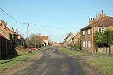
High Catton
Coordinates: 53°58′27″N 0°54′28″W / 53.974175°N 0.907891°W
High Catton is a village in the East Riding of Yorkshire, England. It is situated approximately 6 miles (10 km) north-west of the market town of Pocklington and about 1 mile (1.6 km) south of the village of Stamford Bridge. The village of Low Catton and the River Derwent are 1 mile to the west. Together with Low Catton it forms the civil parish of Catton.
In 1823 High Catton was in the civil parish of Low Catton. Population at the time was 198. Occupations included eleven farmers, a tailor, a joiner & carpenter, a wheelwright, and the landlord of Woodpecker Lass public house. There were also three yeomen. Two carriers operated between the village and York once a week.[1]
References
- ↑ Baines, Edward (1823): History, Directory and Gazetteer of the County of York, p. 185
- Gazetteer – A–Z of Towns Villages and Hamlets. East Riding of Yorkshire Council. 2006. p. 6.
The Victoria County History; Yorkshire: East Riding. Vol 3, edited by K.J.Allison, 1976.
| Wikimedia Commons has media related to High Catton. |