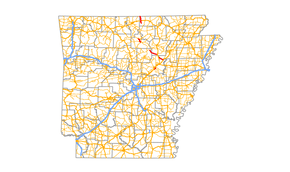
Arkansas Highway 87
| ||||
|---|---|---|---|---|
 | ||||
| Route information | ||||
| Maintained by AHTD | ||||
| Section 1 | ||||
| Length: | 14.0 mi (22.5 km) | |||
| South end: | Fulton CR 2 in Elizabeth | |||
| North end: |
| |||
| Section 2 | ||||
| Length: | 71.2 mi (114.6 km) | |||
| West end: |
| |||
| East end: |
| |||
| Highway system | ||||
| ||||

Highway 87 (AR 87, Ark. 87, and Hwy. 87) is a designation for multiple state highways in Arkansas.
Section 1
Arkansas Highway 87 is a state highway of 14.0 miles (22.5 km) in Fulton County.[1]
Route description
Its southern terminus is 5 miles (8.0 km) south of U.S. Highway 62 at Elizabeth where the road continues east as Fulton County Road 2 towards Mitchell. Its northern terminus is the Missouri state line 6 miles (9.7 km) north of Vidette where it continues as Missouri Supplemental Route AR.
Section 2
Arkansas Highway 87 is a state highway that runs in Stone, Cleburne, Independence, Jackson, and White Counties.[2][3][4][5][6]
Route description
AR 87 begins near Fifty-Six at AR 14. The route runs southeast to meet AR 66, AR 9, AR 5/AR 14 in Mountain View. The route runs with AR 5 until Wolf Bayou as Mountain View Road. AR 87 then angles north, following AR 25 until Concord. The route then becomes Floral Road until Pleasant Plains, when AR 87 meets AR 157 followed by US 167. AR 87 and US 167 continue as Batesville Boulevard, until the concurrency breaks. AR 87 then becomes a rural route through Jackson County. AR 87 enters Bradford, meeting AR 367 before terminating at US 67.
References
- ↑ Arkansas State Highway and Transportation Department. AHTD Fulton County map Retrieved on July 19, 2009.
- ↑ Arkansas State Highway and Transportation Department. AHTD Stone County map Retrieved on July 19, 2009.
- ↑ Arkansas State Highway and Transportation Department. AHTD Cleburne County map Retrieved on July 19, 2009.
- ↑ Arkansas State Highway and Transportation Department. AHTD Independence County map Retrieved on July 19, 2009.
- ↑ Arkansas State Highway and Transportation Department. AHTD Jackson County map Retrieved on July 19, 2009.
- ↑ Arkansas State Highway and Transportation Department. AHTD White County map Retrieved on July 19, 2009.