Arkansas Highway 5
| ||||
|---|---|---|---|---|
 | ||||
| Route information | ||||
| Maintained by AHTD | ||||
| Existed: | 1926 – present | |||
| Section 1 | ||||
| Length: | 44.99 mi[1] (72.40 km) | |||
| West end: |
| |||
| East end: |
| |||
| Section 2 | ||||
| Length: | 0.38 mi[1] (0.61 km) | |||
| South end: | North Scott Street in Little Rock | |||
| North end: | Main Street in North Little Rock | |||
| Section 3 | ||||
| Length: | 146.63 mi[1] (235.98 km) | |||
| South end: |
| |||
| North end: |
| |||
| Highway system | ||||
| ||||

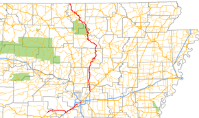
Highway 5 (AR 5, Ark. 5, and Hwy. 5) is a designation for three state highways in Arkansas. The southern segment of 44.99 miles (72.40 km) runs from Highway 7 in Hot Springs north to US Highway 70 (US 70) in Little Rock.[2][3] A northern segment of 146.63 miles (235.98 km) begins at US Highway 67/US Highway 167 in Cabot and runs north to Missouri Route 5, including a lengthy overlap with Highway 25 between Heber Springs and Wolf Bayou.[4][5][5][6] A portion of Highway 5 is designated as part of the Sylamore Scenic Byway.[7]
The Main Street Bridge in Little Rock carries a hidden Highway 5 designation. The bridge is 0.38 miles (0.61 km) in span.[1]
Route description
Hot Springs to Little Rock
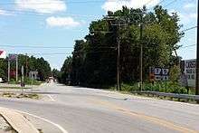
Highway 5 begins north of Hot Springs at Highway 7 and runs northeast to Fountain Lake. In the city the highway has a junction with Highway 128 before entering Saline County and Hot Springs Village.[2] Continuing east, Highway 5 serves as the southern terminus for Highway 9 at Crows. Northwest of Benton the highway has a junction with Highway 298 before entering the city and passing several residential subdivisions. Near Saline Memorial Hospital, Highway 5 has a junction with Interstate 30/US Highway 67/US Highway 70 (I-30/US 67/US 70) and Highway 35. Highway 5 continues onto the freeway, beginning an eastbound concurrency toward Little Rock. Highway 35 runs south toward downtown Benton and eventually Sheridan and Monticello.[8]
I-30/US 67/US 70/AR 5 run northeast past the Congo Rd exit before Highway 5 exits onto the frontage road and onto Military Rd, ending the concurrency. The highway passes the Hester-Lenz House, listed on the National Register of Historic Places (NRHP), prior to the Bryant city limits.[9] Upon entering Bryant, Highway 5 runs parallel to I-30/US 67/US 70 approximately 0.5 miles (0.80 km) north of the limited-access highway. An intersection with Highway 183 (Reynolds Rd) near the historic Andrew Hunter House gives access to downtown Bryant as well as the freeway.[9] Continuing east, Highway 5 intersects Highway 835 (Woody Dr) which leads to the Alexander branch of the Arkansas Department of Human Services's Youth Service Center, after which it enters Pulaski County.[10]
Highway 5 meets Otter Creek Rd and Highway 338 (Baseline Rd), both collector roads for I-30/US 67/US 70 in southwest Little Rock. Entering a suburban area, Highway 5 crosses I-430, passes the historic Dr. Morgan Smith House, and meets Highway 300 (Colonel Glenn Rd) before terminating at US 70 (University Ave) near the University of Arkansas at Little Rock campus.[3]
Main Street Bridge
The Main Street Bridge in Little Rock carries a hidden AR 5 designation. The route is 0.38 miles (0.61 km) in span and multi-lane divided.[1]
Cabot to Heber Springs
AR 5 begins at US 67/167 south of Cabot and runs north to cross AR 89 and AR 319. The route continues north to meet US 64 south of El Paso and AR 310 near Romance. AR 5 and AR 310 form a concurrency that runs until AR 36 in Rose Bud.[11] AR 5 continues north to Heber Springs, where it begins to concur with AR 16/AR 25.
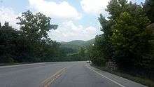
AR 5 leaves AR 25 near Wolf Bayou, when AR 5 begins to run with AR 87, named Mountain View Road. The two routes meet AR 14 in front of the Stone County Medical Center in south Mountain View.[12] AR 5/AR 14/AR 87 run briefly west to Sylamore Avenue, when they meet AR 9. AR 5/AR 9/AR 14 run north through town to Allison, when AR 5 continues northward alone. Passing through the Ozark National Forest, AR 5 emerges near Calico Rock.[13] The route takes a turn northwest, concurring with AR 177 near Norfork. Entering Mountain Home, AR 5 crosses US 62 southeast of town. AR 5 becomes 9th Street, meeting US 412/US 62 BUS/AR 101 in downtown Mountain Home. The route continues northwest to Midway, after which it heads north to the Missouri state line. AR 5 terminates at Route 5.
Missouri Route 5 runs entirely across Missouri and eventually becomes Iowa Highway 5.
History

Highway 5 was created in 1926 as one of the original numbered state highways in Arkansas.[14] At time of creation, AR 5 did not extend south of Little Rock. The segment between Little Rock and Benton is the former alignment of US 67/US 70 in that area and was re-designated as Highway 5 upon completion of the freeway segment of US 67/US 70 (now I-30) in 1955.[15]
Major intersections
| County | Location | mi[1] | km | Destinations | Notes | ||
|---|---|---|---|---|---|---|---|
| Garland | | 0.00 | 0.00 | ||||
| Fountain Lake | 3.76 | 6.05 | |||||
| Saline | Crows | 13.91 | 22.39 | ||||
| | 22.78 | 36.66 | |||||
| Benton | 26.59 | 42.79 | I-30 exit 117 | ||||
| 28.21 | 45.40 | I-30 exit 118 | |||||
| 29.09 | 46.82 | I-30 exit 121 | |||||
| Bryant | 33.15 | 53.35 | |||||
| 34.49 | 55.51 | Woody Drive (AR 835) - Arkansas Juvenile Assessment and Treatment Center | Former AR 111 north | ||||
| Saline–Pulaski county line | Little Rock | Alexander Road | Former AR 111 south | ||||
| Pulaski | 39.19 | 63.07 | |||||
| 40.02 | 64.41 | I-430 exit 1 | |||||
| 42.76 | 68.82 | ||||||
| 44.99 | 72.40 | ||||||
| Gap in route | |||||||
| 0.00 | 0.00 | North Scott Street | |||||
| | Main Street Bridge over the Arkansas River | ||||||
| North Little Rock | 0.38 | 0.61 | Main Street | ||||
| Gap in route | |||||||
| Lonoke | Cabot | 0.00 | 0.00 | ||||
| 0.14 | 0.23 | US 67 exit 16 | |||||
| Lonoke–Pulaski county line | 2.73 | 4.39 | |||||
| Lonoke | | 8.22 | 13.23 | ||||
| White | | 11.97 | 19.26 | ||||
| | 20.83 | 33.52 | |||||
| | 21.57 | 34.71 | |||||
| Rose Bud | 28.65 | 46.11 | South end of AR 36 overlap | ||||
| 28.70 | 46.19 | North end of AR 36 overlap | |||||
| Cleburne | | 38.58 | 62.09 | South end of AR 16 / AR 25 overlap | |||
| see AR 25 | |||||||
| Wolf Bayou | 58.61 | 94.32 | North end of AR 25 overlap | ||||
| Stone | Mountain View | 80.43 | 129.44 | South end of AR 14 overlap | |||
| 82.11 | 132.14 | South end of AR 9 overlap | |||||
| 83.26 | 133.99 | ||||||
| Allison | 87.85 | 141.38 | North end of AR 9 / AR 14 overlap | ||||
| | |||||||
| Izard | Calico Rock | 104.47 | 168.13 | ||||
| Baxter | Norfork | 115.16 | 185.33 | ||||
| 117.98 | 189.87 | ||||||
| Salesville | 120.07 | 193.23 | |||||
| | 124.17 | 199.83 | |||||
| | 124.61 | 200.54 | |||||
| | 128.89 | 207.43 | Interchange | ||||
| Mountain Home | 130.42 | 209.89 | South end of AR 201 overlap | ||||
| 130.78 | 210.47 | South end of US 62B overlap | |||||
| 130.90 | 210.66 | ||||||
| 131.22 | 211.18 | North end of US 62B overlap | |||||
| 131.29 | 211.29 | North end of AR 201 overlap | |||||
| Midway | 137.26 | 220.90 | South end of AR 178 overlap | ||||
| 137.36 | 221.06 | North end of AR 178 overlap | |||||
| | 145.42 | 234.03 | |||||
| | 146.63 | 235.98 | Missouri state line | ||||
1.000 mi = 1.609 km; 1.000 km = 0.621 mi
| |||||||
See also
-
 Arkansas portal
 -
 U.S. Roads portal
Notes
References
- 1 2 3 4 5 6 Planning and Research Division (2012). "Arkansas Road Log Database" (MDB). Arkansas State Highway and Transportation Department. Retrieved May 3, 2013.
- 1 2 General Highway Map, Garland County, Arkansas (PDF) (Map). 1:62500. Cartography by Planning and Research Division. Arkansas State Highway and Transportation Department. December 18, 2007. Retrieved May 9, 2013.
- 1 2 General Highway Map, Pulaski County, Arkansas (PDF) (Map). 1:62500. Cartography by Planning and Research Division. Arkansas State Highway and Transportation Department. December 22, 2010. Retrieved May 9, 2013.
- ↑ General Highway Map - Lonoke County, Arkansas (PDF) (Map) (5/17/10 ed.). Arkansas State Highway and Transportation Department. Retrieved August 28, 2010.
- 1 2 General Highway Map - Cleburne County, Arkansas (PDF) (Map) (4/23/07 ed.). Arkansas State Highway and Transportation Department. Retrieved August 28, 2010.
- ↑ General Highway Map - Baxter County, Arkansas (PDF) (Map) (4/27/07 ed.). Arkansas State Highway and Transportation Department. Retrieved August 28, 2010.
- ↑ "Sylamore Scenic Byway". US DOT. Retrieved August 28, 2009.
- ↑ General Highway Map, Saline County, Arkansas (PDF) (Map). 1:62500. Cartography by Planning and Research Division. Arkansas State Highway and Transportation Department. October 20, 2010. Retrieved May 9, 2013.
- 1 2 National Park Service (2010-07-09). "National Register Information System". National Register of Historic Places. National Park Service.
- ↑ Map of Alexander and Bryant, Saline County, Arkansas (PDF) (Map). Cartography by Planning and Research Division. Arkansas State Highway and Transportation Department. March 2009. Retrieved May 9, 2013.
- ↑ General Highway Map - White County, Arkansas (PDF) (Map) (1/7/09 ed.). Arkansas State Highway and Transportation Department. Retrieved March 12, 2011.
- ↑ General Highway Map - Stone County, Arkansas (PDF) (Map) (8/24/01 ed.). Arkansas State Highway and Transportation Department. Retrieved March 12, 2011.
- ↑ General Highway Map - Izard County, Arkansas (PDF) (Map) (1/8/02 ed.). Arkansas State Highway and Transportation Department. Retrieved March 12, 2011.
- ↑ "Map of State of Arkansas Showing System of Primary and Secondary Federal Aid Roads and Connecting State Roads and Progress of Improvements." 1926. Arkansas State Highway Department. Map. Archived July 7, 2011, at the Wayback Machine. Retrieved March 12, 2011.
- ↑ "Minutes of the Meeting" (PDF). Arkansas State Highway Commission. May 18, 1955. p. 1997. Retrieved January 16, 2013.