Hispar Glacier
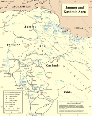
Hispar Glacier is a 49 km (30 mi) long glacier in the Karakoram Mountains of Gilgit–Baltistan, Pakistan which meets the 63 km (39 mi) long Biafo Glacier at the Hispar La (Pass) at an altitude of 5,128 m (16,824 ft) to create the world's longest glacial system outside of the polar regions.
Details
This 100 km (62 mi) highway of ice connects two ancient mountain kingdoms, Nagar (immediately south of Hunza) in the west with Baltistan in the east. The extreme steepness of the hillsides and strenuous nature of the boulder hopping on the lateral moraines and hillsides make this route's upper half the most difficult part of the Biafo - Hispar traverse. Only the Hispar La day includes walking on the Hispar Glacier. The crossing of four major tributary glaciers from the north is most taxing, and potentially high nullah crossings can be dangerous. The views of 7,800-metre (25,600 ft) peaks and of the snow-covered cliffs and mountains on the south side of the glacier are particularly impressive.[1]
Rivers
The Hispar River, a tributary of the Hunza River, rises from the meltwater of the glacier.
See also
- Central Karakoram National Park
- List of mountains in Pakistan
- List of highest mountains
- List of glaciers
References
External links
Glaciers of Gilgit-Baltistan | |
|---|---|
|
Coordinates: 36°05′N 75°16′E / 36.083°N 75.267°E