History of Kiribati
_-_journal.pone.0059855.g001.png)
The islands which now form the Republic of Kiribati have been inhabited for at least seven hundred years, and possibly much longer. The initial Micronesian population, which remains the overwhelming majority today, was visited by Polynesian and Melanesian invaders before the first European sailors visited the islands in the 17th century. For much of the subsequent period, the main island chain, the Gilbert Islands, was ruled as part of the British Empire. The country gained its independence in 1979 and has since been known as Kiribati.
Pre-history
The islands had been inhabited by Micronesians for several millennia (at least 2,000 years, probably 3,000). The I-Kiribati or Gilbertese people settled what would become known as the Gilbert Islands (named for British captain Thomas Gilbert by von Krusenstern in 1820) some time in between 3000 BC[1][2] and 1300 AD.[3] Subsequent invasions by Samoans and Tongans introduced Polynesian elements to the previously installed Micronesian culture and invasions by Fijians introduced Melanesian elements, but extensive intermarriage produced a population reasonably homogeneous in appearance, language and traditions.
Contact with other cultures
In 1606 Pedro Fernandes de Queirós sighted Butaritari and Makin, which he named the Buen Viaje (‘good trip’ in Spanish) Islands).[4][4]
Captain John Byron passed through the islands in 1764 during his circumnavigation of the globe as captain of HMS Dolphin.[5]
In 1788 Captain Thomas Gilbert in the Charlotte and Captain John Marshall in the Scarborough. Messrs. Gilbert and Marshall crossed through Abemama, Kuria, Aranuka, Tarawa, Abaiang, Butaritari, and Makin without attempting to land on shore.[6]
Further exploration

In 1820, the islands were named the Gilbert Islands or îles Gilbert (in French) by Adam Johann von Krusenstern, an Estonian admiral of the Czar after the British Captain Thomas Gilbert, who crossed the archipelago in 1788. In 1824 French captain Louis Duperrey was the first to map the whole Gilbert Islands archipelago. He commanded La Coquille on its circumnavigation of the earth (1822–1825).[7]
Two ships of the United States Exploring Expedition, USS Peacock (1828) and USS Flying Fish (1838), under the command of Captain Hudson, visited many of the Gilbert Islands (then called the Kingsmill Islands or Kingsmill Group in English). While in the Gilberts, they devoted considerable time to mapping and charting reefs and anchorages.[8] Alfred Thomas Agate made drawings of men of the Makin islands.[9]
Colonial era
Whalers, blackbirders, and merchant vessels arrived in great numbers in the 19th century, and the resulting upheaval fomented local tribal conflicts and introduced damaging European diseases. In an effort to restore a measure of order, the Gilbert Islands and the neighboring Ellice Islands (now Tuvalu) were declared as the British Protectorate by Captain Davis of HMS Royalist (1883) on 27 May 1892.[10]
British Western Pacific Territories
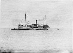
The British Western Pacific Territories (BWPT) were administered by a High Commissioner resident in Fiji. A Resident Commissioner, Charles Swayne, was appointed in 1893 following the protectorate on the Gilbert group and on the Ellice group becoming formal and effective in 1892. The protectorate's headquarters was established on Tarawa Atoll in 1896, where Resident Commissioner Telfer Campbell presided from 1896 until 1908. The headquarters were then moved to Banaba (which was referred to officially by the British authorities as Ocean Island), and continued upon the transition to a Crown Colony. This move in headquarters arose from the operations of the Pacific Phosphate Company resulting in good shipping connections to Ocean Island, and in any case the role of the British colonial authorities emphasised the procurement of labour for the mining and shipping of phosphate and keeping order among the workers.[11][12]
Banaba (or Ocean Island) was included in the protectorate in 1900 and then in the colony in 1916. In the same year, Fanning Island and Washington Island were included in it together with the islands of the Tokelau or Union Islands.[13]
In 1916, the administration of the BWTP ended and the islands became a Crown Colony on 12 January 1916.[14]
Gilbert and Ellice Islands Colony
The islands became a Crown Colony on 12 January 1916 by the Gilbert and Ellice Islands Order in Council, 1915.[15] Christmas Island was included in the colony in 1919 although it was contested by the U.S. under the Guano Islands Act of 1856.[16] Tokelau was transferred to New Zealand administration in 1926. The Phoenix Islands were added in 1937 and the five islands of the Central and Southern Line Islands were added in 1972.[13]
The Gilbert and Ellice Islands Colony continued to be administered by a Resident Commissioner. One very famous colonial officer in the colony was Sir Arthur Grimble (1888–1956), at first as a cadet officer in 1914, under Edward Carlyon Eliot who was Resident Commissioner of the BWPT then the colony from 1913 to 1920. This period is described in Eliot's book "Broken Atoms" (autobiographical reminiscences) (Pub. G. Bles, London, 1938) and in Sir Arthur Grimble's "A Pattern of Islands" (Pub. John Murray, London, 1952). Arthur Grimble became the Resident Commissioner of the colony in 1926. In 1930 Grimble, issued revised laws, Regulations for the good Order and Cleanliness of the Gilbert and Ellice Islands, which replaced laws created during the BWTP.
Banaba remained the headquarters of the colony until the British evacuation in 1942. After World War II, the colony headquarters was re-established on Tarawa, first on Betio islet (then occupied by American forces following the Battle for Tarawa) and subsequently on Bairiki islet.[13][17][18]
World War II
Japan seized part of the islands during World War II to form part of their island defenses. On 20 November 1943, Allied forces threw themselves against Japanese positions at Tarawa Atoll and Makin Atoll in the Gilberts, resulting in some of the bloodiest fighting of the Pacific campaign. The Battle of Tarawa and the Battle of Makin were a major turning point in the war for the Allies, which battles were the implementation of "Operation Galvanic".[19]
Self-determination
Transition to self-determination
The formation of the United Nations Organisation after World War II resulted in the United Nations Special Committee on Decolonization committing to a process of decolonisation; as a consequence the British colonies in the Pacific started on a path to self-determination.
As a consequence of the Ellice Islands self-determination referendum, 1974,[20] separation occurred in two stages. The Tuvaluan Order 1975 made by the Privy Council, which took effect on 1 October 1975, recognised Tuvalu as a separate British dependency with its own government. The second stage occurred on 1 January 1976 when separate administrations were created out of the civil service of the Gilbert and Ellice Islands Colony.[21]
Independence for Kiribati
The Gilberts obtained internal self-government in 1977 and held general elections in February 1978 which saw Ieremia Tabai elected Chief Minister at only age 27. Kiribati attained independence on 12 July 1979 by the Kiribati Independence Order 1979 made by the Privy Council.
Although the indigenous Gilbertese language name for the Gilbert Islands proper is Tungaru, the new state chose the name "Kiribati," the Gilbertese rendition of "Gilberts," as an equivalent of the former colony to acknowledge the inclusion of islands which were never considered part of the Gilberts chain.[22] The United States gave up its claims to 14 islands of the Line and Phoenix chains (previously asserted under the Guano Islands Act) in the 1979 Treaty of Tarawa.[23]
Post independent
Post-independence politics were initially dominated by the Commonwealth of Nations' youngest head of state, Ieremia Tabai, just 29, Kiribati's first beretitenti (president), who served for three terms from 1979 to 1991. Teburoro Tiito was elected beretitenti in 1994, and reelected in 1998 and 2002. However, in the previous parliamentary elections in 2002, Tito's opponents won major victories, and in March 2003 he was ousted in a no-confidence vote (having served the maximum three terms, he is barred by the constitution to run for another term). His temporary replacement was Tion Otang, the Council of State chairman. Following the constitution, another presidential election was held, in which two brothers, Anote and Harry Tong, were the two main candidates (the third one, Banuera Berina won just 9,1%). Anote Tong, London School of Economics graduate, won on 4 July 2003, and was sworn in as president soon afterward. He was re-elected in 2007 and in 2012 for a third term.
The Banaba issue
An emotional issue has been the protracted bid by the residents of Banaba to secede and have their island placed under the protection of Fiji. Because Banaba was devastated by phosphate mining,[11][12] the vast majority of Banabans moved to the island of Rabi in the Fiji Islands in the 1940s where they now number some 5,000 and enjoy full Fijian citizenship. The Kiribatian government has responded by including several special provisions in the Constitution, such as the designation of a Banaban seat in the legislature and the return of land previously acquired by the government for phosphate mining. Only around 300 people remain on Banaba. Despite being part of Kiribati, Banaba's municipal administration is by the Rabi Council of Leaders and Elders, which is based on Rabi. In 2006, Teitirake Corrie, the Rabi Island Council's representative to the Parliament of Kiribati, called for Banaba to secede from Kiribati and join Fiji.
See also
Further reading
- Cinderellas of the Empire, Barrie Macdonald, IPS, University of the South Pacific, 2001
- Les Insulaires du Pacifique, I.C. Campbell & J.-P. Latouche, PUF, Paris, 2001
- Kiribati: aspects of history, Sister Alaima Talu et al., IPS, USP, 1979, reprinted 1998
- A Pattern of Islands, Sir Arthur Grimble, John Murray & Co, London, 1952
- Return to the Islands, Sir Arthur Grimble, John Murray & Co, London, 1957
References
- ↑ Cinderellas of the Empire, Barrie Macdonald, IPS, University of the South Pacific, 2001, p.1
- ↑ Encyclopædia Britannica, "Kiribati"
- ↑ I-Kiribati Ministry of Finance and Economic Development: "History"
- 1 2 Maude, H.E. (1959). "Spanish Discoveries in the Central Pacific: A Study in Identification". The Journal of the Polynesian Society. 68 (4): 284–326.
- ↑ "Circumnavigation: Notable global maritime circumnavigations". Solarnavigator.net. Retrieved 20 July 2009.
- ↑ Samuel Eliot Morison (1944-05-22). "The Gilberts & Marshalls: A distinguished historian recalls the past of two recently captured pacific groups". Life magazine. Retrieved 2009-10-14.
- ↑ Chambers, Keith S.; Munro, Doug (1980). "The Mystery of Gran Cocal: European Discovery and Mis-Discovery in Tuvalu". The Journal of the Polynesian Society. 89 (2): 167–198.
- ↑ Tyler, David B. – 1968 The Wilkes Expedition. The First United States Exploring Expedition (1838–42). Philadelphia: American Philosophical Society
- ↑ The extensive report of the expedition has been digitized by the Smithsonian Institution. The visit to the Gilbert Islands (then called the Kingsmill Islands) is described in Chapter 2 in volume 5, pp. 35–75, 'Ellice's and Kingsmill's Group', http://www.sil.si.edu/DigitalCollections/usexex/
- ↑ Resture, Jane. "TUVALU HISTORY – 'The Davis Diaries' (H.M.S. Royalist, ship's journal 1892)". Retrieved 20 September 2011.
- 1 2 Maslyn Williams & Barrie Macdonald (1985). The Phosphateers. Melbourne University Press. ISBN 0-522-84302-6.
- 1 2 Ellis, Albert F. (1935). Ocean Island and Nauru; Their Story. Sydney, Australia: Angus and Robertson, limited. OCLC 3444055.
- 1 2 3 Macdonald, B. K. (1982). Cinderellas of the Empire: Towards a History of Kiribati and Tuvalu, Australian National University Press, Canberra.
- ↑ Annexation of the Gilbert and Ellice Islands to his Majesty's dominions : at the Court at Buckingham Palace, the 10th day of November, 1915. Great Britain, Privy Council, Gilbert and Ellice Islands Order in Council, 1915 (Suva, Fiji : Government Printer). 1916.
- ↑ (Imperial). (1875). "Pacific Islanders Protection Act, ss. 6-11". Retrieved 20 January 2015.
- ↑ "FORMERLY DISPUTED ISLANDS". U.S. Department of the Interior, Office of Insular Affairs. Archived from the original on 30 September 2007.
- ↑ Maude, H. E., & Doran, E., Jr. (1966). The precedence of Tarawa Atoll. Annals of the Association of American Geographers, 56, 269-289.
- ↑ Williams, M., & Macdonald, B. K. (1985). The phosphateers: A history of the British Phosphate Commissioners and the Christmas Island Phosphate Commission. Melbourne University Press, Carlton, Vic.
- ↑ "To the Central Pacific and Tarawa, August 1943--Background to GALVANIC (Ch. 16, p. 622)". Retrieved 15 March 2015.
- ↑ Nohlen, D, Grotz, F & Hartmann, C (2001) Elections in Asia: A data handbook, Volume II, p831 ISBN 0-19-924959-8
- ↑ McIntyre, W. David (2012). "The Partition of the Gilbert and Ellice Islands" (PDF). Island Studies Journal. 7 (1): 135–146.
- ↑ Reilly Ridgell. Pacific Nations and Territories: The Islands of Micronesia, Melanesia, and Polynesia. 3rd Edition. Honolulu: Bess Press, 1995. p. 95
- ↑ US Department of State Background Note
External links
- U.S. State Department Background Note: Kiribati
- The Kiribati international date line adjustment of 1994/95
| Gilbert Islands |  | |
|---|---|---|
| Phoenix Islands | ||
| Line Islands | ||
| West of Gilberts | ||
| Reefs | ||
| ||