Holland, Kentucky
| Holland, Kentucky | |
|---|---|
| Unincorporated community | |
|
Intersection of State Route 99 and State Route 100 | |
 | |
| Coordinates: 36°41′56″N 86°04′06″W / 36.69889°N 86.06833°WCoordinates: 36°41′56″N 86°04′06″W / 36.69889°N 86.06833°W | |
| Country | United States |
| State | Kentucky |
| County | Allen |
| Elevation | 807 ft (246 m) |
| Time zone | Central (CST) (UTC-6) |
| • Summer (DST) | CDT (UTC-5) |
| ZIP codes | 42153 |
| Area code(s) | 270 |
| GNIS feature ID | 494393[1] |

Holland is an unincorporated community in the southeast corner of Allen County, Kentucky, United States. The community, primarily a rural area on farmland, is approximately 10 miles east of Scottsville.
A post office was established in the community in 1881, and named for early settler William Holland.[2]
A tornado hit near Holland around 2 AM on Wednesday, February 6, 2008, killing 4 people and injuring several more.[3]
There is an Old Order Mennonite community in Holland, that started as one of the "Christian Communities" founded by Elmo Stoll. Soon after the early death of Elmo Stoll in 1998, the "Christian Communities" began to disband. The community in Holland then decided to join the Noah Hoover Mennonites in nearby Scottsville.[4]
Notes
- ↑ "US Board on Geographic Names". United States Geological Survey. 2007-10-25. Retrieved 2008-01-31.
- ↑ Rennick, Robert M. (1987). Kentucky Place Names. University Press of Kentucky. p. 143. Retrieved 2013-04-28.
- ↑ "18 Tornadoes Confirmed In 14 Kentucky Counties". WKYT. February 6, 2008. p. 1. Retrieved December 20, 2012.
- ↑ Community by Elmo Stoll at anabaptistchurch.org
Municipalities and communities of Allen County, Kentucky, United States | ||
|---|---|---|
| City | 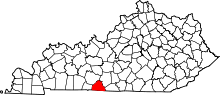 | |
| Unincorporated communities |
| |
This article is issued from Wikipedia - version of the 10/11/2016. The text is available under the Creative Commons Attribution/Share Alike but additional terms may apply for the media files.