Hollands Diep

Hollands Diep (pre-1947 spelling: Hollandsch Diep) is a wide river in the Netherlands[1] and an estuary of the Rhine and Meuse river. Through the Scheldt-Rhine Canal it connects to the Scheldt river and Antwerp.
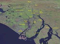
The Bergse Maas river and the Nieuwe Merwede river join near Lage Zwaluwe to form the Hollands Diep. The Dordtsche Kil connects to it near Moerdijk. Near Numansdorp it splits into the Haringvliet and the Volkerak.
History
The Hollands Diep was formed as a result of the extensive flooding event of 1216, which breached the dunes of Voorne and created a deep saltwater inlet (the current Haringvliet). During a second flooding event, the St. Elizabeth floods, this inlet connected to the Merwede and became an important estuary of the Rhine and Meuse rivers. From that moment on, the freshwater part of the estuary (east of the Hellegatsplein) was renamed Hollands Diep. The former river Striene, that used to connect the Meuse with the Scheldt, was completely destroyed by these flooding events and can no longer be recognised on maps.
River crossings
At this point where the Hollands Diep splits, there is a road traffic node on an artificial island (the Hellegatsplein), connecting to the Hoeksche Waard island on the north by the Haringvliet bridge, to the Goeree-Overflakkee on the west by the Hellegatsdam, and to the mainland on the southeast by the Volkerak Sluices.
On the east side of the Hollands Diep the Moerdijk bridges connect the Dordrecht island on the north to the mainland on the south: a road bridge, a railroad bridge; a second railroad bridge has recently been constructed for the HSL-Zuid.
References
- ↑ "Hollandsch Diep" (in Dutch). Rijkswaterstaat.
Coordinates: 51°42′00″N 4°35′02″E / 51.70000°N 4.58389°E