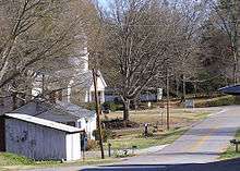
Homer, Georgia
| Homer, Georgia | |
|---|---|
| Town | |
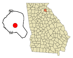 Location in Banks County and the state of Georgia | |
| Coordinates: 34°20′2″N 83°29′59″W / 34.33389°N 83.49972°WCoordinates: 34°20′2″N 83°29′59″W / 34.33389°N 83.49972°W | |
| Country | United States |
| State | Georgia |
| County | Banks |
| Area | |
| • Total | 9.7 sq mi (25.0 km2) |
| • Land | 9.6 sq mi (24.9 km2) |
| • Water | 0.04 sq mi (0.1 km2) |
| Elevation | 814 ft (248 m) |
| Population (2010) | |
| • Total | 1,141 |
| • Density | 118/sq mi (45.7/km2) |
| Time zone | Eastern (EST) (UTC-5) |
| • Summer (DST) | EDT (UTC-4) |
| ZIP code | 30547 |
| Area code(s) | 706 |
| FIPS code | 13-39720[1] |
| GNIS feature ID | 0332015[2] |
Homer is a town in Banks County, Georgia, United States. The population was 1,141 at the 2010 census.[3] The town of Homer has a mayor, Doug Cheek, and five councilpersons, Sandra Garrison, Jerry Payne, Chris Tucker, Keven Cape, and Betty Boarders. The town is the county seat of Banks County.[4]
History
Homer was founded in 1858 as seat for the newly established Banks County.[5] Homer was incorporated as a town in 1859, and its first courthouse was built in 1863.
Homer is among the earliest to hold the world record for an Easter egg hunt - 80,000 eggs, listed in the 1985 Guinness Book of World Records. The event in the small town of 1,100 people is an Easter Sunday tradition that has lasted 47 years. The egg hunt each year draws about 5,000 egg hunters, children and adults. Even though it no longer holds the record, Homer has long touted its annual hunt as the world's largest.
Geography
Homer is located at 34°20′2″N 83°29′59″W / 34.33389°N 83.49972°W (34.333851, -83.499844).[6]
According to the United States Census Bureau, the town has a total area of 9.7 square miles (25.0 km2), of which 9.6 square miles (24.9 km2) is land and 0.04 square miles (0.1 km2), or 0.38%, is water.[3]
Education
Banks County students in kindergarten to grade twelve are in the Banks County School District, which consists of two elementary schools, a middle school and a high school.[7] The district has 150 full-time teachers and over 2,428 students.[8]
- Banks County Elementary School
- Banks County Primary School
- Banks County Middle School
- Banks County High School
Demographics
| Historical population | |||
|---|---|---|---|
| Census | Pop. | %± | |
| 1870 | 120 | — | |
| 1880 | 140 | 16.7% | |
| 1900 | 221 | — | |
| 1910 | 228 | 3.2% | |
| 1920 | 291 | 27.6% | |
| 1930 | 248 | −14.8% | |
| 1940 | 283 | 14.1% | |
| 1950 | 340 | 20.1% | |
| 1960 | 612 | 80.0% | |
| 1970 | 365 | −40.4% | |
| 1980 | 734 | 101.1% | |
| 1990 | 742 | 1.1% | |
| 2000 | 950 | 28.0% | |
| 2010 | 1,141 | 20.1% | |
| Est. 2015 | 1,144 | [9] | 0.3% |
As of the census[1] of 2000, there were 950 people, 366 households, and 249 families residing in the town. The population density was 99.1 people per square mile (38.2/km²). There were 406 housing units at an average density of 42.4 per square mile (16.3/km²). The racial makeup of the town was 84.32% White, 11.79% African American, 1.16% Native American, 0.84% Asian, 1.16% from other races, and 0.74% from two or more races. Hispanic or Latino of any race were 2.00% of the population.
There were 366 households out of which 36.3% had children under the age of 18 living with them, 54.4% were married couples living together, 10.4% had a female householder with no husband present, and 31.7% were non-families. 26.2% of all households were made up of individuals and 12.6% had someone living alone who was 65 years of age or older. The average household size was 2.60 and the average family size was 3.16.
In the town the population was spread out with 28.1% under the age of 18, 10.5% from 18 to 24, 29.1% from 25 to 44, 20.5% from 45 to 64, and 11.8% who were 65 years of age or older. The median age was 33 years. For every 100 females there were 95.5 males. For every 100 females age 18 and over, there were 95.1 males.
The median income for a household in the town was $35,500, and the median income for a family was $41,667. Males had a median income of $30,147 versus $23,438 for females. The per capita income for the town was $17,353. About 8.9% of families and 13.3% of the population were below the poverty line, including 14.3% of those under age 18 and 21.1% of those age 65 or over.
References
- 1 2 "American FactFinder". United States Census Bureau. Retrieved 2008-01-31.
- ↑ "US Board on Geographic Names". United States Geological Survey. 2007-10-25. Retrieved 2008-01-31.
- 1 2 "Geographic Identifiers: 2010 Demographic Profile Data (G001): Homer town, Georgia". U.S. Census Bureau, American Factfinder. Retrieved October 29, 2013.
- ↑ "Find a County". National Association of Counties. Retrieved 2011-06-07.
- ↑ Hellmann, Paul T. (May 13, 2013). Historical Gazetteer of the United States. Routledge. p. 233. Retrieved 30 November 2013.
- ↑ "US Gazetteer files: 2010, 2000, and 1990". United States Census Bureau. 2011-02-12. Retrieved 2011-04-23.
- ↑ Georgia Board of Education, Retrieved May 30, 2010.
- ↑ School Stats, Retrieved May 30, 2010.
- ↑ "Annual Estimates of the Resident Population for Incorporated Places: April 1, 2010 to July 1, 2015". Retrieved July 2, 2016.
- ↑ "Census of Population and Housing". Census.gov. Retrieved June 4, 2015.
Municipalities and communities of Banks County, Georgia, United States | ||
|---|---|---|
| Cities | 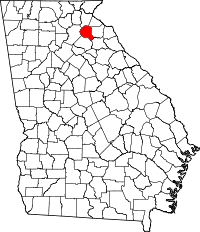 | |
| Towns | ||
| Unincorporated communities | ||
| Footnotes | ‡This populated place also has portions in an adjacent county or counties | |