Homewood, California
| Homewood | |
|---|---|
| Unincorporated community | |
|
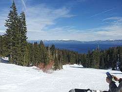
Lake Tahoe in winter seen from Homewood | |
 Homewood | |
| Coordinates: 39°05′13″N 120°09′37″W / 39.08694°N 120.16028°WCoordinates: 39°05′13″N 120°09′37″W / 39.08694°N 120.16028°W | |
| Country |
|
| State |
|
| County | Placer |
| Elevation[1] | 1,900 m (6,234 ft) |
| Time zone | Pacific (PST) (UTC-8) |
| • Summer (DST) | PDT (UTC-7) |
| ZIP code | 96141 |
| Area code(s) | 530 |
| GNIS feature ID | 261434[2] |
Homewood is an unincorporated community in Placer County, California of about 200 residents, located on the west shore of Lake Tahoe. It is located 5.5 miles (8.9 km) south of Tahoe City and north of Chambers Landing and Tahoma.[3] It is the location of Homewood Mountain Resort. The community of Tahoe Pines uses Homewood's ZIP Code, 96141.[4] Thomas McConnell is said to be the founder of Homewood, after he purchased lakefront property on Lake Tahoe's west shore and laid out the Homewood District with property on either side of Highway 89 in 1889. The Homewood Post Office was later established in 1909.
Homewood Mountain Resort
The Homewood area on the shore of Lake Tahoe is also host to the Homewood Mountain Ski Resort. The resort comprises 1,260 acres (5.1 km2), 7 ski lifts, 60 runs and 1,650 vertical feet with a summit of 7,880 feet (2,400 m).[5]
References
- ↑ U.S. Geological Survey Geographic Names Information System: Homewood, California
- ↑ "US Board on Geographic Names". United States Geological Survey. 2007-10-25. Retrieved 2008-01-31.
- ↑ Durham, David L. (1998). California's Geographic Names: A Gazetteer of Historic and Modern Names of the State. Clovis, Calif.: Word Dancer Press. p. 499. ISBN 1-884995-14-4.
- ↑ http://www.zipareacode.net/homewood-ca.htm
- ↑ "Homewood-The Mountain". Skihomewood.com. Retrieved 2010-08-11.
External links
-
 Homewood travel guide from Wikivoyage
 - Trailspotting: Homewood Mountain Resort GPS/Mapping data and photograph