Hopewell Township, Muskingum County, Ohio
| Hopewell Township, Muskingum County, Ohio | |
|---|---|
| Township | |
|
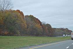
Interstate 70 southeast of Hopewell | |
 Location of Hopewell Township in Muskingum County | |
| Coordinates: 39°57′16″N 82°10′57″W / 39.95444°N 82.18250°WCoordinates: 39°57′16″N 82°10′57″W / 39.95444°N 82.18250°W | |
| Country | United States |
| State | Ohio |
| County | Muskingum |
| Area | |
| • Total | 38.8 sq mi (100.5 km2) |
| • Land | 38.3 sq mi (99.3 km2) |
| • Water | 0.5 sq mi (1.2 km2) |
| Elevation[1] | 968 ft (295 m) |
| Population (2000) | |
| • Total | 3,038 |
| • Density | 79.2/sq mi (30.6/km2) |
| Time zone | Eastern (EST) (UTC-5) |
| • Summer (DST) | EDT (UTC-4) |
| ZIP code | 43746 |
| Area code(s) | 740 |
| FIPS code | 39-36372[2] |
| GNIS feature ID | 1086721[1] |
Hopewell Township is one of the twenty-five townships of Muskingum County, Ohio, United States. The 2000 census found 3,038 people in the township, 2,947 of whom lived in the unincorporated portions of the township.[3]
Geography
Located on the western edge of the county, it borders the following townships:
- Licking Township - north
- Falls Township - east, north of Springfield Township
- Springfield Township - east, south of Falls Township
- Newton Township - southeast
- Madison Township, Perry County - south
- Hopewell Township, Perry County - southwest corner
- Bowling Green Township, Licking County - west, south of Hopewell Township
- Hopewell Township, Licking County - west, north of Bowling Green Township
- Hanover Township, Licking County - northwest corner
Part of the village of Gratiot is located in western Hopewell Township, and the unincorporated community of Hopewell lies at the center of the township.
Name and history
It is one of five Hopewell Townships statewide.[4]
Hopewell Township was described in 1833 as having four churches and three physicians.[5]
Government
The township is governed by a three-member board of trustees, who are elected in November of odd-numbered years to a four-year term beginning on the following January 1. Two are elected in the year after the presidential election and one is elected in the year before it. There is also an elected township fiscal officer,[6] who serves a four-year term beginning on April 1 of the year after the election, which is held in November of the year before the presidential election. Vacancies in the fiscal officership or on the board of trustees are filled by the remaining trustees.
References
- 1 2 "US Board on Geographic Names". United States Geological Survey. 2007-10-25. Retrieved 2008-01-31.
- ↑ "American FactFinder". United States Census Bureau. Retrieved 2008-01-31.
- ↑ Muskingum County, Ohio — Population by Places Estimates Ohio State University, 2007. Accessed 15 May 2007.
- ↑ "Detailed map of Ohio" (PDF). United States Census Bureau. 2000. Retrieved 2007-02-16.
- ↑ Kilbourn, John (1833). The Ohio Gazetteer, or, a Topographical Dictionary. Scott and Wright. p. 242. Retrieved 12 December 2013.
- ↑ §503.24, §505.01, and §507.01 of the Ohio Revised Code. Accessed 4/30/2009.
External links
Municipalities and communities of Muskingum County, Ohio, United States | ||
|---|---|---|
| City | 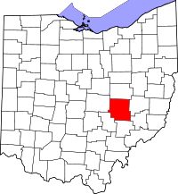 | |
| Villages | ||
| Townships | ||
| CDPs | ||
| Unincorporated communities |
| |
| Footnotes | ‡This populated place also has portions in an adjacent county or counties | |