Horšovský Týn
| Horšovský Týn | ||
| Town | ||
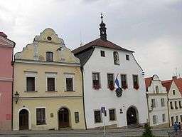 Town hall | ||
|
||
| Country | Czech Republic | |
|---|---|---|
| Region | Plzeň | |
| District | Domažlice | |
| Commune | Horšovský Týn | |
| Parts | Borovice (Domažlice District), Dolní Metelsko, Hašov, Horní Metelsko, Horšov, Kocourov, Lazce, Malé Předměstí, Město, Nová Ves (Domažlice District), Oplotec, Plzeňské Předměstí, Podhájí, Podražnice, Semošice, Svatá Anna, Svinná, Tasnovice, Valdorf, Velké Předměstí, Věvrov | |
| Center | Náměstí Republiky | |
| - elevation | 376 m (1,234 ft) | |
| - coordinates | 49°31′47″N 12°56′36.5″E / 49.52972°N 12.943472°ECoordinates: 49°31′47″N 12°56′36.5″E / 49.52972°N 12.943472°E | |
| Area | 71.44 km2 (27.58 sq mi) | |
| Population | 4,906 (2007-06-04) | |
| Density | 69/km2 (179/sq mi) | |
| First mentioned | 1184 | |
| Mayor | Josef Holeček | |
| Timezone | CET (UTC+1) | |
| - summer (DST) | CEST (UTC+2) | |
| Postal code | 345 25 - 346 01 | |
  Location in the Czech Republic | ||
| Wikimedia Commons: Horšovský Týn | ||
| Statistics: statnisprava.cz | ||
| Website: www.horsovskytyn.cz/mesto | ||
| Horšovský Týn | |
| Municipality with Extended Competence | |
| Country | Czech Republic |
|---|---|
| Region | Plzeň |
| Parts | Horšovský Týn, Staňkov |
| Area | 288.65 km2 (111.45 sq mi) |
| Population | 13,690 (2005-12-31) |
| Density | 47/km2 (122/sq mi) |
| Horšovský Týn | |
| Municipality with Commissioned Local Authority | |
| Country | Czech Republic |
|---|---|
| Region | Plzeň |
| Little District | Horšovský Týn |
| Municipalities | Blížejov, Horšovský Týn, Křenovy, Meclov, Mezholezy, Mířkov, Semněvice, Srby (Domažlice District), Velký Malahov, Vidice |
| Area | 220.46 km2 (85.12 sq mi) |
| Population | 8,729 (2005-12-31) |
| Density | 40/km2 (104/sq mi) |
Horšovský Týn (Czech pronunciation: [ˈhorʃofskiː ˈtiːn]; German: Bischofteinitz) is a town in the Plzeň Region of the Czech Republic. It lies on the River Radbuza, some 40 km (25 mi) south-west of the region capital Plzeň. From 1938 to 1945 it was, as Bischofteinitz, one of the municipalities in Sudetenland.
History
A settlement on the right bank of the Radbuza river was first established in the mid-13th century, on land owned by the archbishops of Prague. The town was besieged and defended during the Hussite wars between 1422 and 1431. The German Elector John, Count Palatine of Neumarkt (Johann von Pfalz-Neumarkt) helped relieve the town.
After the death of Louis II of Hungary at the Battle of Mohács in 1526, Archduke Ferdinand of Austria became King of Bohemia and the country became a constituent state of the Habsburg Monarchy to 1918.
After 1539 Bischofteinitz belonged to the House of Lobkowicz. After the Thirty Years War the town passed to the counts on Trauttmansdorff, in whose possession the castle remained until 1945. Bischofteinitz developed into an important, if minor, provincial centre bordering Bavaria.
During the late 19th century and especially after 1918 Czechs began moving into the district in large numbers. In 1938 the town and region were annexed into Nazi Germany as part of the Sudetenland.
Main Attractions
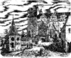
The main attraction is a castle that was rebuilt in 1547 by Agostino Galli. Much of the original Gothic castle, the palace portals and some rooms have been preserved. In the town itself there are two Gothic churches and a former Capuchin monastery.
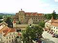 Tyn Castle
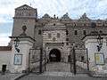 Tyn Castle
Inhabitants
Until 1945 the area was populated by native Germans who spoke a Northern Bavarian dialect (Nordbairisch). These people were expelled by the Beneš decrees following World War II. On 1 December 1930 Horšovský Týn had 3,117 inhabitants; on 17 May 1939 there were 2995, and on 22 May 1947 2,393 inhabitants.
People
- Felix Kadlinský (1613–1675), writer
- Johannes Matthias Alexander Ecker (1766–1829), surgeon
- Joseph Johann von Littrow (1781–1840), astronomer
- Eduard Baar von Baarenfels (1855–1935), Feldmarschalleutnant
- Egon Weißenbach (born 1897), painter
- Peter Kneißl (born 1938), historian
Resources
- Czech Statistical Office (2005), Vybrané údaje podle správních obvodů obcí s rozšířenou působností a správních obvodů obcí s pověřeným obecním úřadem k 31. 12. 2005, retrieved 2005-03-08
External links
- Czech Travel Guide Site - General info about Horsovsky Tyn Chateau, contact info, opening hours etc.
 Media related to Horšovský Týn at Wikimedia Commons