Kdyně
| Kdyně | ||
| Town | ||
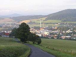 The town from the north | ||
|
||
| Country | Czech Republic | |
|---|---|---|
| Region | Plzeň | |
| District | Domažlice | |
| Commune | Domažlice | |
| Municipality | Kdyně | |
| Parts | 10
| |
| Center | Square | |
| - elevation | 455 m (1,493 ft) | |
| - coordinates | 49°23′26″N 13°2′18″E / 49.39056°N 13.03833°ECoordinates: 49°23′26″N 13°2′18″E / 49.39056°N 13.03833°E | |
| Area | 28.73 km2 (11.09 sq mi) | |
| Population | 5,283 (2015-01-01) | |
| Density | 184/km2 (477/sq mi) | |
| First mentioned | 1384 | |
| Mayor | Jan Löffelmann | |
| Timezone | CET (UTC+1) | |
| - summer (DST) | CEST (UTC+2) | |
| Postal code | 345 06 - 345 10 | |
  Location in the Czech Republic | ||
| Wikimedia Commons: Kdyně | ||
| Statistics: statnisprava.cz | ||
| Website: www.kdyne.cz | ||
_-_coat-of-arms.png)
| Kdyně | |
| Municipality with Commissioned Local Authority | |
| Country | Czech Republic |
|---|---|
| Region | Plzeň |
| Little District | Domažlice |
| Municipalities | Brnířov, Chodská Lhota, Kdyně, Kout na Šumavě, Libkov, Loučim, Mezholezy, Němčice, Nová Ves, Pocinovice, Spáňov, Úboč, Úsilov, Všepadly, Všeruby |
| Area | 165.37 km2 (64 sq mi) |
| Population | 9,486 (2005-12-31) |
| Density | 57/km2 (148/sq mi) |
Kdyně (Czech pronunciation: [ˈɡdɪɲɛ]; German: Neu Gedein) is a town in the Plzeň Region of the Czech Republic. It lies some 60 km (37 mi) to the South-West from the region capital of Plzeň.
Kdyně is also a municipality with Commissioned Local Authority within the Domažlice Municipality with Extended Competence.
Resources
- Czech Statistical Office (2005), Vybrané údaje podle správních obvodů obcí s rozšířenou působností a správních obvodů obcí s pověřeným obecním úřadem k 31. 12. 2005, retrieved 2005-03-08
External links
 Media related to Kdyně at Wikimedia Commons
This article is issued from Wikipedia - version of the 8/19/2016. The text is available under the Creative Commons Attribution/Share Alike but additional terms may apply for the media files.