Hoschton, Georgia
| Hoschton, Georgia | |
|---|---|
| City | |
| Motto: "Planning our future, honoring our past." | |
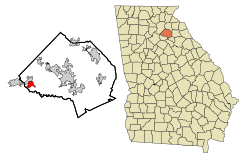 Location in Jackson County and the state of Georgia | |
| Coordinates: 34°5′46″N 83°45′40″W / 34.09611°N 83.76111°WCoordinates: 34°5′46″N 83°45′40″W / 34.09611°N 83.76111°W | |
| Country | United States |
| State | Georgia |
| County | Jackson |
| Area | |
| • Total | 2.4 sq mi (6.3 km2) |
| • Land | 2.4 sq mi (6.3 km2) |
| • Water | 0 sq mi (0 km2) |
| Elevation | 902 ft (275 m) |
| Population (2010) | |
| • Total | 1,377 |
| • Density | 445.8/sq mi (169.8/km2) |
| Time zone | Eastern (EST) (UTC-5) |
| • Summer (DST) | EDT (UTC-4) |
| ZIP code | 30548 |
| Area code(s) | 706 |
| FIPS code | 13-40056[1] |
| GNIS feature ID | 0356322[2] |
| Website | www.cityofhoschton.com |
Hoschton is a city in Jackson County, Georgia, United States. The population was 1,377 at the 2010 census.
Geography
Hoschton is located at 34°05′46″N 83°45′40″W / 34.096164°N 83.761083°W.[3]
According to the United States Census Bureau, the city has a total area of 2.5 square miles (6.5 km2). Subsequent annexations have seen the city grow to 2.8 square miles (7.3 km2).
Hoschton city proper is located entirely within Jackson County.
The Hoschton zip code 30548 goes well beyond the city limits, and results in the post office delivering mail into four counties: Jackson, Gwinnett, Hall, and parts of Barrow counties. Hoschton's zip code is used in about 40% of the Braselton town limits.
The city borders Braselton.
Demographics
| Historical population | |||
|---|---|---|---|
| Census | Pop. | %± | |
| 1890 | 207 | — | |
| 1900 | 290 | 40.1% | |
| 1910 | 429 | 47.9% | |
| 1920 | 377 | −12.1% | |
| 1930 | 427 | 13.3% | |
| 1940 | 364 | −14.8% | |
| 1950 | 378 | 3.8% | |
| 1960 | 370 | −2.1% | |
| 1970 | 509 | 37.6% | |
| 1980 | 490 | −3.7% | |
| 1990 | 642 | 31.0% | |
| 2000 | 1,070 | 66.7% | |
| 2010 | 1,377 | 28.7% | |
| Est. 2015 | 1,433 | [4] | 4.1% |
As of the census[1] of 2000, there were 1,070 people, 388 households, and 304 families residing in the city. The population density was 437.2 people per square mile (168.6/km²). There were 404 housing units at an average density of 165.1 per square mile (63.7/km²). The racial makeup of the city was 93.36% White, 4.86% African American, 0.19% Native American, 0.09% Asian, 0.28% from other races, and 1.21% from two or more races. Hispanic or Latino of any race were 1.40% of the population. As of July 2009 the population is estimated at 1,612.
There were 388 households out of which 37.4% had children under the age of 18 living with them, 64.2% were married couples living together, 10.8% had a female householder with no husband present, and 21.4% were non-families. 17.8% of all households were made up of individuals and 5.7% had someone living alone who was 65 years of age or older. The average household size was 2.76 and the average family size was 3.12.
In the city the population was spread out with 28.3% under the age of 18, 8.0% from 18 to 24, 30.5% from 25 to 44, 22.6% from 45 to 64, and 10.6% who were 65 years of age or older. The median age was 34 years. For every 100 females there were 95.3 males. For every 100 females age 18 and over, there were 95.2 males.
The median income for a household in the city was $50,625, and the median income for a family was $57,917. Males had a median income of $40,000 versus $27,153 for females. The per capita income for the city was $22,416. About 9.5% of families and 11.5% of the population were below the poverty line, including 12.5% of those under age 18 and 18.8% of those age 65 or over.
References
- 1 2 "American FactFinder". United States Census Bureau. Retrieved 2008-01-31.
- ↑ "US Board on Geographic Names". United States Geological Survey. 2007-10-25. Retrieved 2008-01-31.
- ↑ "US Gazetteer files: 2010, 2000, and 1990". United States Census Bureau. 2011-02-12. Retrieved 2011-04-23.
- ↑ "Annual Estimates of the Resident Population for Incorporated Places: April 1, 2010 to July 1, 2015". Retrieved July 2, 2016.
- ↑ "Census of Population and Housing". Census.gov. Retrieved June 4, 2015.
External Links
Municipalities and communities of Jackson County, Georgia, United States | ||
|---|---|---|
| Cities | 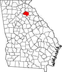 | |
| Towns | ||
| Footnotes | ‡This populated place also has portions in an adjacent county or counties | |