Hoshangabad
| Hoshangabad होशंगाबाद | |
|---|---|
| city | |
|
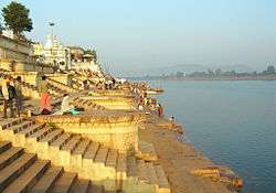
Sethani Ghat is an important landmark of the city. | |
 Hoshangabad | |
| Coordinates: 22°45′N 77°43′E / 22.75°N 77.72°ECoordinates: 22°45′N 77°43′E / 22.75°N 77.72°E | |
| Country | India |
| State | Madhya Pradesh |
| District | Hoshangabad |
| Government | |
| • Body | Bhartiya Janta Party |
| • MLA | Dr. Sita Sharan Sharma |
| Elevation | 278 m (912 ft) |
| Population (2001) | |
| • Total | 117,956(2,011) |
| Language | |
| • Official | Hindi |
| Time zone | IST (UTC+5:30) |
| PIN | 461001 |
| Telephone code | 07574 |
| Vehicle registration | MP 05 |
| Website |
www |
Hoshangabad is a city and a municipality in Hoshangabad district in the Indian state of Madhya Pradesh. It is a city in the central India region, on the south bank of the Narmada River, and is the administrative center of Hoshangabad District.
History
The city is named after ruler of Narmadapuram, Hoshang Shah. The city was earlier called Narmadapuram after the Narmada River. Later the name was changed to Hoshangabad after Hoshang Shah, the first ruler of Malwa. Hoshangabad district was part of the Nerbudda (Narmada) Division of the Central Provinces and Berar, which became the state of Madhya Bharat (later Madhya Pradesh) after India's independence in 1947.[1]
The city is famous for its beautiful ghats along the banks of the Narmada river, Sethani ghat is a major attraction. There are colourful celebrations in the city on Narmada Jayanti. During celebrations this year the CM announced the efforts to rename the town. A Satsang Bhavan on the ghat has regular visits by Hindu saints who hold regular religious discourses on Ramcharitmanas and Geeta.
Geography
Hoshangabad is located at 22°45′N 77°43′E / 22.75°N 77.72°E.[2] It has an average elevation of 278 metres (912 feet).
Boundaries
Northern boundary of the district is river Narmada. Across this the district of Raisen and Sehore lies. The district of Betul lies in the south, where as the Harda district faces with the western and south-western boundaries and Narsingpur and Chhindwara districts, close to the north-eastern and south-eastern sides of the district respectively.
Climate
The climate of Hoshangabad district is normal. All the seasons come in the district. An average height from the sea level is 331 m and average rain fall is 134 cm. The average maximum and minimum temperatures are 40 deg.C and 19 deg.C respectively. Overall, the climate of the district is neither more hot nor more cool except the winter season of the Pachmarhi.
Road and Rail
Hoshangabad is well connected by road and rail from the state capital, Bhopal and it is about 70 km away from it. Hoshangabad railway station is connected by rail with all major cities of the state. One of its tehsils, Itarsi is linked with all major cities of the country due to junction of main railway routes of the country. It is 18 km from the district headquarters. From Itarsi, one can reach Pachmarhi via Pipariya, which is 64 km by train.
Landmark
Sethani ghat is an important landmark of the city, on the banks of River Narmada. It is about 7 km downstream from the confluence of Tawa and Narmada rivers.
Demographics
As of 2001 India census,[3] Hoshangabad had a population of 97,357. Males constitute 53% of the population and females 47%. Hoshangabad has an average literacy rate of 73%, higher than the national average of 59.5%: male literacy is 80%, and female literacy is 66%. In Hoshangabad, 13% of the population is under 6 years of age.
Education
There are 960 primary schools, 207 Middle schools, 69 senior secondary schools and 9 schools operated by Tribal Department. Many educational institutions including the Narmada MahaVidhyalaya (NMV) were established by prominent visionary late Pt. R L Sharma. There are 11 colleges and one is a polytechnic. All the colleges are affiliated to Barkatullah University, Bhopal. There is an office of Saksharta Programme which is running many literacy programs in the district.
Economy
The economy largely depends on agriculture. Hoshangabad is one of the largest producer of Soya Bean. The land is quite fertile and farmers have good canal irrigation facilities from the Tawa reservoir throughout the year. The farmers employ rotation of crops and their major income depends on soya bean and wheat.
The city has traditional way of living with many engaged in occupations enough for sustaining life. The city has abundant availability of water. Hoshangabad has high income per capita amongst cities of Madhya Pradesh.
In Hoshangabad city, there is only one industrial establishment: the Security Papers Mill Hoshangabad, a unit of Printing and Minting Corporation of India Ltd. The main trade in the district are handicraft, silk, leather, pulses etc. Other than these, the main business deals in the delivering of sand and tiles which come from river Narmada.
Nearby attractions
- Sethani ghat—This is an old ghat built on the bank of river Narmada. Many temples are near it.
- Ancient petroglyphs on Adamgarh hills consist of petroglyphs (rock paintings); it is a site of national importance; it is two kilometres away from the main city.
- Bandhrabhan—a holy fair takes place every year at Bandhrabhan, as it is a meeting point of the main rivers Narmada and Tawa.
- Salkanpur—Goddess Durga temple approximate 35 km from Hoshangabad. It can be reached via Budni or from the Bhopal-NasurullaGanj route. It is approximately 70 km from Bhopal. This sacred siddhpeeth of Vindhyavasni Beejasan devi (one of the incarnation of the Hindu goddess Durga) is on an 800 foot high hillrock, in the village Salkanpur near Rehti village. The deity, Ma Durga Beejasan is held in high esteem by her followers & local. Thousands of people visit this place everyday climbing more than 1000 steps. Every year a grand fair is held in salkanpur during Navratris. It is very old Temple but at present temple renovate by Salkanpur Trust.
- Hushang Shah Fort—This is an old fort built by the Malwa ruler Hoshang Shah. It is adjacent to river Narmada.
- TAWA Resort—Tawa Reservoir is a large reservoir on the Tawa River in central India. It is located in Hoshangabad District of Madhya Pradesh state. The reservoir was formed by the construction of the Tawa Dam, which began in 1958 and was completed in 1978. The dam provides for irrigation to several thousand hectares of farming land in Hoshangabad and Harda districts. It is also a big tourist attraction during the monsoon months. A Cruise boat service has been started by the tourism department for visitors to the dam and reservoir.
Pachmarhi and Satpura Tiger Reserve
Pachmarhi, the only hill station of Madhya Pradesh, and a pilgrimage site for Siva bhaktas from the surrounding countryside, is now the base for enjoying the natural riches of the Satpura Tiger Reserve as well. The tiger reserve encompasses the oldest forest reserve of India, the Bori Wildlife Sanctuary, and the breathtaking scenery of the Pachmarhi with the Satpura National Park. It was at Pachmarhi where Captain James Forsyth constructed the famous Bison Lodge and founded the Forest Department of Madhya Pradesh. His travelogue, 'The Central Indian Highlands', on his march from Jabalpur to Pachmarhi in 1861-62, transports one into the long lost times of tribal culture and rich wilderness.
Other attractions
- Khedapati Hanuman Mandir
- Ramji Baba Samadhi
- Pahadiya (Ancient rock carvings by Pandavas)
- Ancient Shani Mandir
- Hoshang Shah Fort
- Bandrabhaan (Sangam of river Narmada and river Tawa)
Notable People
- Raj Chandra Bose - He was born in Hoshangabad, India.
References
- ↑ Hunter, William Wilson, Sir, et al. (1908). Imperial Gazetteer of India, Volume 6. 1908-1931; Clarendon Press, Oxford
- ↑ Falling Rain Genomics, Inc - Hoshangabad
- ↑ "Census of India 2001: Data from the 2001 Census, including cities, villages and towns (Provisional)". Census Commission of India. Archived from the original on 2004-06-16. Retrieved 2008-11-01.