House numbering
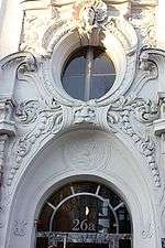
.jpeg)
House numbering is the system of giving a unique number to each building in a street or area, with the intention of making it easier to locate a particular building. The house number is often part of a postal address. The term describes the number of any building (residential or not) or vacant lot with a mailbox.
House numbering schemes vary by place, and in many cases even within cities. In some areas of the world, including many remote areas, houses are not numbered but named.
History
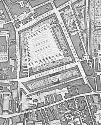
A house numbering scheme was present in Pont Notre-Dame in Paris in 1512.[1] However, the purpose of the numbering was generally to determine the distribution of property ownership in the city, rather than for the purpose of organization.
In the 18th century the first street numbering schemes were applied across Europe, to aid in administrative tasks and the provision of services such as the post. The New View of London reported in 1708 that "at Prescott Street, Goodman's Fields, instead of signs, the houses are distinguished by numbers".[2] Parts of the Parisian suburbs were numbered in the 1720s; the houses in the Jewish quarter in the city of Prague in the Austrian Empire were numbered in the same decade to aid the authorities in the conscription of the Jews.
Street numbering took off in the mid 18th century, especially in Prussia, where authorities were ordered to "fix numbers on the houses...in little villages on the day before the troops march in". In the 1750s and 60s, street numbering on a large scale was applied in Madrid, London, Paris and Vienna, as well as many other cities across Europe.[3] On 1 March 1768, King Louis XV of France decreed that all French houses outside of Paris affix house numbers, primarily for tracking troops quartered in civilian homes.[4][5]
By region
Australia and New Zealand
In Australia and New Zealand, the current standard (Australia/New Zealand joint standard AS/NZS 4819:2003 - Geographic Information – Rural & Urban Addressing) is directed at local governments that have the primary responsibility for addressing and road naming. The standard calls for numbers in newly created streets be assigned odd numbers to sites on the left and even numbers to the right when facing in the direction of increasing numbers (the European system). This standard came into force in 2003. Some exceptions exist where the road forms part of the boundary between different council areas or cities. For example, Underwood Road in Rochedale South has non-standard numbering, as it forms part of the boundary between Logan City and the city of Brisbane.
In New South Wales, the vast majority of streets were numbered before 2003, and some streets exist with odd numbers assigned to houses on the right of the street when facing in the direction of increasing numbers. There is no plan to reassign these numbers.
On some urban roads (e.g. Parramatta Road in Sydney) numbers will typically ascend until the road crosses a council or suburb boundary, then start again at 1 or 2. Long roads can thus have several occurrences of each number. In semi-rural and rural areas, where houses and farms are widely spaced, a numbering system based on tens of metres or (less commonly) metres has been devised. Thus a farm 2,300 metres (7,500 ft) from the start of the road, on the right-hand side would be numbered 230.[6]
Another notable exception to the standard system in Australia is found in Ballarat Central where the US system of increasing house numbers by a century after a major cross street is deployed. Also streets are designated North or South depending upon their orientation to Sturt Street.
East Asia
In Japan and South Korea, a city is divided into small numbered zones. The houses within each zone are then labelled in the order in which they were constructed, or clockwise around the block. This system is comparable to the system of sestieri (sixths) used in Venice.
In Hong Kong, a former British colony, the British and European norm to number houses on one side of the street with odd numbers, and the other side with even numbers, is generally followed. Some roads or streets along the coastline may however have numbering only on one side, even if the opposite side is later reclaimed. These roads or streets include Ferry Street, Connaught Road West and Gloucester Road.[7]
Most Chinese cities use the European system, with odd numbers on one side of the road and even numbers on the opposite side. In high-density old Shanghai, a street number may be either a hao ("号" hào) or nong ("弄" nòng/lòng), both of them being numbered successively. A hao refers a door rather than a building, for example, if a building with the address 25 Wuming Rd is followed by another building, which has three entrances opening to the street, the latter will be numbered as three different hao, from 27 to 29 Wuming Rd. A nong, sometimes translated as "lane", refers to a block of buildings. So if in the above example the last building is followed by an enclosed compound, it will have the address "lane 31, Wuming Rd". A nong is further subdivided in its own hao, which do not correlate with the hao of the street, so the full address of an apartment within a compound may look like "apartment 5005, no. 7, lane 31, Wuming Rd".
Western and Southern Europe
In Europe the most common house numbering scheme, in this article referred to as the European scheme, is to number each plot on one side of the road with ascending odd numbers, from 1, and those on the other with ascending even numbers, from 2 or sometimes 0. The odd numbers are usually on the left side of the road, looking in the direction in which the numbers increase. Where additional buildings are inserted or subdivided, these are often suffixed a, b, etc. (in Spain and France, bis, ter, quater). Where buildings are later combined, they may use just one of the original numbers, combine them ("13/15"), or give their address as a range (e.g. "13–17"; not to be construed as including the even numbers 14 and 16). Where some plots are not built upon, there may be considerable gaps in the numbering scheme. If a lot of buildings are later built along a stretch of the street, either a range of unused numbers above the current highest house number may be used, introducing confusing discontinuities, or the remainder of the street must be renumbered. Buildings with multiple entrances might have a single number for the entire building, or a separate number assigned to every entrance.
Other local numbering schemes are also in use for administrative or historic reasons, including clockwise and anti-clockwise numbering, district-based numbering, distance-based numbering and double numbering.
Finland
The Finnish numbering system incorporates a solution to the problem which arose with the mass migration from rural areas into the towns and cities. Addresses are always Street Name followed by Street address number. With new building infill, new addresses are created by adding letters representing the new ground level access point within the old street address, and if there are more apartments than ground level access points, the next number is the apartment number within the new development. The original street numbering system followed the pattern of odd numbers on one side and even numbers on the other side, with lower numbers towards the center of town and higher numbers further away from the center. The infill numbering system avoids renumbering the entire street when developments are modified. For example, imagine that Mannerheimtie 5 (a large mansion house on a large city plot) was demolished and replaced with 4 new buildings each with 2 stairwells all accessible from Mannherheimtie. The 8 new access stairwells are labelled A B C D E F G and H (each with the letter visible above the stairwell). Each stairwell has 4 apartments on 5 floors, so the new development has 160 new addresses in all running from Mannerheimtie 5 A 1 through to Mannerheimtie 5 H 160.
Netherlands
In Haarlem, Netherlands, red numbers are used for upstairs apartments. In the Netherlands when more buildings are constructed than numbers were allotted when the street numbering was planned, discontinuity of numbering is avoided by giving multiple adjacent buildings the same number, with a letter suffix starting at "A".
Portugal
In Portugal, the European scheme is the most commonly used house numbering style. However, in Porto and several other cities in the Portuguese Northern region, houses are numbered in the North American style, with the number assigned being proportional to the distance in meters from the baseline of the street.
In many new planned neighborhoods of Portugal, the houses and other buildings are identified by a lote (plot) number and not by a street number. The lote is the construction plot number used in the urban plan and it is part of a single number series for the entire neighborhood, regardless of the street where it is located. In theory and in most of the cases, the use of a lote number system is provisional, this being replaced by a traditional street number system some time after the neighborhood is built and inhabited. However, in many neighborhoods, the lote numbers are kept for many years, some never even being replaced by street numbers.
Italy
In Venice, Italy, houses are numbered within districts known as sestieri, resulting in just six series for the entire city. Similarly, small villages in Italy may also occasionally use a single progressive series for all house numbers.[8] In Genoa and in Florence houses are marked with black (sometimes also blue in Florence) numbers while businesses are usually (but not always) given red numbers, resulting in two distinct series for every street. The street numbers of businesses are denoted in writing (e.g., documents, online directories, etc.) by the addition of the letter "r"—e.g., Via dei Servi 21r.
United Kingdom
In many areas, particularly in rural areas, many houses remain named but un-numbered. The odd numbers will typically, although not always, be on the left-hand side as seen from the centre of the town or village, with the lowest numbers at the end of the street closest to the town centre. Intermediate properties usually have a number suffixed A, B, C, etc., but there are several that have been given a half number, e.g. the old police station at 20½ Camberwell Church Street. At least one property (built next to no. 2 after the street had been numbered) has been numbered zero.
In some places, all plots on one side of a street are numbered consecutively, continuing clockwise back down on the opposite side of the street: for example in Pall Mall, culs-de-sac, streets with buildings only on one side, some new towns, and in many villages in Wales. For instance, 10 Downing Street, the official home of the Prime Minister, is next door to 11 Downing Street, the home of the Chancellor of the Exchequer. Houses which surround squares are usually numbered consecutively clockwise.
Before the early/mid 19th century, it was common in England for numbering to proceed sequentially along one side of the road and then back down the other. Subsequent changes to local numbering can present pitfalls to researchers using historic street directories, for instance. If a street has no opposite houses, often the plots are numbered with only odd numbers, starting at 1. An interesting variation is seen in Stratford, London E15. On the east side of the main road between Stratford and Leytonstone houses up to no. 122 are "Leytonstone Road". The next house, however, is 124 High Road, Leytonstone.
Some UK local authorities avoid the number 13 for house numbering, because that number is considered by some to be unlucky.[9]
In the UK fanlights in front doors were introduced in the 1720s, and these showed a unique representation of a house number for identification.[10] More recently, with contemporary architectural design and modern house building techniques, the design of house numbers has also evolved. House numbers today are frequently made from acrylic, aluminium or glass, or with more traditional materials such as ceramic, brass, slate or stone.
Unlike other countries, in the UK there is no centralised universal provision of uniform house number plates by local authorities, so this remains the responsibility of house-owners, as does their maintenance.
Central and Eastern Europe
In Central and Eastern Europe, with some exceptions, houses are typically numbered in the European style. Many streets, however, use the "boustrophedon" system described below.

Czech Republic and Slovakia
In some Czech and Slovak cities and settlements, two numbering systems are used concurrently.
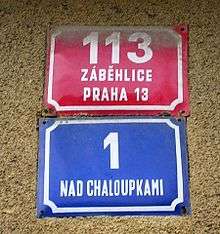
The basic house number is the "old" or "conscription number" (Czech popisné číslo, Slovak súpisné číslo). The conscription number is unique within the municipal part (a village, a quarter, mostly for one cadastral area) or within a whole small municipality.
For makeshift and recreational buildings in the Czech Republic, "registration number" (evidenční číslo) from a separate number series is used instead of the descriptive number. Somewhere, this number begins with zero or with the letter "E" or has different colour to distinction or contains words like "nouzová stavba" (= makeshift structure), "chata" (= ca. weekend house) etc.
In some of settlements where streets have their names (mostly in cities), there are used also the "new" or "orientational numbers" (Czech orientační číslo, Slovak orientačné číslo) concurrently. The orientational numbers are arranged sequentially within the street or square. If the building is on a corner or has two sides, it can have two or more orientation numbers, one for each of the adjacent streets or squares. Solitary houses distant from named streets often have no orientation number. In some places, the name of a small quarter is used as a street name. If there is a new building between two older numbered ones, the orientation number is distinguished with an additional lower case letter (the sequence could be 5, 7, 9, 9a, 9b, 9c, 11, 13). In the 1930–1950s in Brno, lower case letters were used for separate entrances of modern block houses perpendicular to the street.
Either number may be used in addresses. Sometimes, businesses will use both numbers to avoid confusion, usually putting the descriptive (or registration) number first: "Hlavní 20/7." The two (or three) types of numbers are commonly distinguished by colour of the sign. Each municipality can have its own traditional or official rules and colours. In Prague and many other Bohemian cities, descriptive numbers are red, orientation numbers are blue and "evidential" numbers are green or yellow or red. In many Bohemian municipalities, descriptive numbers are blue, black or are not unified. In Brno and some Moravian and Slovak cities, descriptive numbers are white-black signs, orientation numbers are red-white signs. Many cities and municipalities have different rules.
Formerly, Roman numerals signifying the city district were added to the conscription number: e.g. "125/III" means conscription number 125 in district number III (in Prague, this was Malá Strana). Roman numerals were used both in cities and in village municipalities with more settlements. Nowadays, the name of the settlement is preferred instead of Roman numerals.
The first conscription numbering was ordered by Maria Theresa in 1770 and implemented in 1770–1771. The series was given successively as the soldiers went through the settlement describing houses with numbers. Thereafter, every new house was allocated the next number sequentially, irrespective of its location. Most villages still use their original number series from 1770–1771. In cities, houses have been renumbered once or more often in order to be sequential – the first wave of renumbering came in 1805–1815. In 1857, the Austrian Emperor allowed a new system of numbering by streets. This new system was introduced in the biggest cities (Prague, Brno) in the 1860s. In 1884, land registration books were introduced and they used the old (conscription) numbers as a permanent and stable identifier of buildings. The new (orientation) numbers continue to be used concurrently.
Turkey
In most of Turkey, currently the European house numbering scheme is applied. The Istanbul Metropolitan Municipality introduced new house numbering and street signs in 2007 and they are still in use. New signs's creators are Aykut Köksal and Bülent Erkmen.[11]
Austria
A double numbering system also existed in some Austrian cities.
Germany
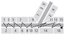
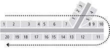
In some older streets in northern and eastern Germany, mainly in the former Kingdom of Prussia and adjoining areas, including parts of Berlin and Hamburg, the "horseshoe" numbering system (counter-clockwise "boustrophedon"-style numbering) was used for the numbering of new streets up until the 1920s, after which the European system was introduced for new streets.
Under the horseshoe numbering scheme, starting from one end, the buildings on the right side of the street were numbered sequentially from the near end to the far end of the street. The next number was then assigned to the last building on the left, opposite side of the street, the following numbers sequentially doubling back along the left side of the street. The building with the highest number would be the first on the left side, facing building number 1 across the street. The horseshoe numbering system remains in use in older streets in many German cities, notably Berlin, although newer adjoining streets may use modern European numbering. Kurfürstendamm in Berlin is a well-known example of a street where the horseshoe numbering scheme is still in use, although the numbering today starts with 11 at Breitscheidplatz, with number 237 across the street being the highest number.[12]
Former Soviet Union
_in_Kiev.JPG)
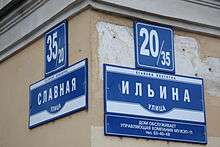
In Russia and many other former USSR countries, the European style is generally used, with numbers starting from the end of the street closest to the town center. Buildings or plots at street intersections may be assigned a composite number, which includes the number along the intersecting street separated by a slash (Russian: дробь), like in Нахимова, 14/41 (14 is the number along Nakhimova street and 41 is the number along intersecting street).
The odd numbers are usually on the left side of the road, looking in the direction in which the numbers increase; though in some cities (including Saint Petersburg) the odd numbers are on the right side. Some cities (for example, Nizhniy Novgorod) have mixed numbering: odd numbers on the right in some parts of the city and on the left in others.
Soviet era housing districts (microdistricts) often have a complicated network of access lanes thought too small to merit their own names. Buildings in these lanes are ascribed to larger streets which may be quite far from their location; a building placed along a street may sometimes be ascribed to another street. This all makes finding a building by its address a challenging task sometimes.
In some cities, especially hosting large scientific or military research centers in Soviet time, the numbering might be different: houses may have numbers related to the block rather than the street, thus 12-й квартал, дом 3 (Block 12, House 3),[13] similar to the Japanese and Korean systems (see below). Aktau is one example of this.
When a numbered plot contains multiple buildings, they are assigned an additional component of the street address, called корпус (building), which is usually a sequentially assigned number unique within the plot (but sometimes contains letters as in 15а, 15б, 15в and so on). So, a Russian street address may look like Московское шоссе, дом 23, корпус 2 (Moscow Street, plot 23, building 2), or Льва Толстого, дом 14б (Leo Tolstoy Street, plot 14, building b).
On very long roads in suburban areas kilometer numbering system also may be used (like Australian rural numbering system). For example, 9-й км Воткинского шоссе (9th kilometer of Votkinsk Highway), and Шабердинский тракт, 7-й км (7th kilometer of Shaberdy Road).
Latin America

Some countries in Latin America use systems similar to those in Europe. Houses are numbered in ascending order from downtown to the border of the city. In Mexico, the cities are usually divided in Colonias, which are small or medium areas. The colonia is commonly included in the address before the postal code. Sometimes when houses merge in a street or new constructions are built after the numbering was made, the address can become ambiguous. When a number is repeated a letter is added to the newest house. For example, if there are two 35s, one remains as 35 and the second one becomes 35A or 35Bis. In Venezuela houses, buildings, and streets have names instead of numbers.
It is sometimes common that in remote towns or non-planned areas inside the cities that the streets do not have any name and the houses do not have numbers. In these cases the address of the houses are usually the name of the person or family, the name of the area or town, and "Dirección Conocida" (Known Address), which means that the house of the family is known by almost all the community. This kind of addressing is only used in remote towns or small communities near highways. For people living near highways or roads the usual address is the kilometer of the road in which the house is established; if there's more than one, some references might be written or the "Dirección Conocida" may be added. In countries like Brazil and Argentina, but also in some villages in France, this scheme is used also for streets in cities, where the house number is the distance, measured in meters, from the house to the start of the street.
North America
On most streets in the United States and Canada, odd numbers are on one side and even numbers on the other. Often, the number assigned is proportional to the distance from some baseline, so not all numbers are used. On very long roads or in areas sufficiently far from the baseline, four- or five-digit addresses are common. For example, along the Overseas Highway in the Florida Keys, house numbers indicate their distance from Mile Marker 0 in Key West. The mileage is found by dividing the house number by 1000 (for example, 77220 Overseas Highway is 77.2 miles from Mile Marker 0). In rural areas, typical numbering may be 1000 for each mile from the nearest town center or radiating from a certain zero-point at the corner or center of a county.
In many localities, addresses often increase by 100 for each cross street, so that the building numbers in each block vary only in the last two digits. In some cities they are consecutive within each block, so that a block where one side is numbered 501, 503, 505, 507, 509, 511 is followed by a block beginning with 601. Generally, within a single city there is a single base point used for all addresses; numbering of all streets therefore reflects its distance from that base point, and directionals (north, south, east, west) are used to refer to buildings on streets which run in that direction and are in that direction from the base point. The numbering system thus resembles a Cartesian coordinate system. Most cities start their numbering from the base point in either single-digits or at 100. For example, if an address is located six blocks north of a city's base point, it would likely be numbered in either the 600 or 700 range and often the designator "north" added to the street name. This is often omitted if the street does not cross beyond the base point or changes names when doing so.
Some cities such as Albuquerque and Washington, D.C. use a quadrant system with two perpendicular roads, highways, railroads, or other geographic line or boundary forming the X and Y axis of the numbering system. Here, the block numbers increase with distance from the intersecting axis, and the quadrant is suffixed to the street name (i.e. 98th St SW, San Mateo Blvd NE) regardless if the road crosses into another quadrant or not. It is common to indicate block numbers on street signs.
Often, when numbered streets are used, the address numbers on perpendicular streets will use the number of the lower-numbered cross street as the "hundreds" portion of the number for each block. For example, in Cleveland, Ohio, the former Central YMCA has an address of 2200 Prospect Avenue, and it sits at the corner of Prospect Avenue and 22nd Street. When the cross street is a lettered street, a similar numbering system is sometimes used. For example, in Washington, D.C., the block of 7th Street, N.W., between D and E streets, N.W., is designated as the 400 block, meaning that building numbers on that block are in the range from 400 to 499 inclusive.
Apartment demarcation is usually a decision of the local authority; in most cities numbers are assigned to each apartment per floor or by suites for office buildings or letter/number combinations, while in duplex, divided building or Polish flat settings, fraction symbols such as "½" or "¼" are used (for example, the address 10½ Beacon Street in Boston refers to the Boston Athenæum). In Milwaukee and many cities in Wisconsin, apartments are often demarcated by a letter such as A, B, C, etc. for each apartment above the main apartment on the first floor (i.e. 604D in an address would refer to the fourth apartment in that structure).
References
| Wikimedia Commons has media related to House numbers. |
- ↑ "The Numbering of Houses". The New York Times. Adolph Ochs. 16 July 1898. Retrieved 27 September 2015.
- ↑ Roy Porter (1998). London: A Social History. Harvard University Press. p. 126. ISBN 978-0-674-53839-9.
- ↑ "Addressing the Houses: The Introduction of House Numbering in Europe". Retrieved 2012-12-17.
- ↑ Rose-Redwood, Reuben S. (1 April 2008). "Indexing the great ledger of the community: urban house numbering, city directories, and the production of spatial legibility". Journal of Historical Geography. 34 (2): 286–310. doi:10.1016/j.jhg.2007.06.003.
- ↑ Rose-Redwood, Reuben (2009) [originally published in 2008 in Journal of Historical Geography but revised in 2009]. "Indexing the Great Ledger of the Community: Urban House Numbering, City Directories, and the Production of Spatial Legibility". In Berg, Lawrence D.; Vuolteenaho, Jani. Critical Toponymies: The Contested Politics of Place Naming. Ashgate Publishing, Ltd. p. 199. ISBN 978-0-7546-7453-5. Retrieved 26 September 2015.
- ↑ "Street Addressing Working Group and the National Street Addressing Standard". Intergovernmental Committee on Survey and Mapping. March 19, 2008. Retrieved February 24, 2010.
- ↑
- ↑ Example of house numbers in Sistiana, Italy "Portopiccolo ha già il suo indirizzo: Sistiana 231 per le case, negozi al 232". Il Piccolo. January 20, 2014. Retrieved September 23, 2014.
- ↑ Bowlby, Chris. "Would you buy a number 13 house?". BBC News. December 12, 2008. Retrieved February 24, 2010.
- ↑ The Fanlight Number Company, July 19, 2009. http://www.fanlightnumbers.co.uk/history.html
- ↑ , Istanbul's red signs. (Turkish)
- ↑ Wittstock, Bernhard (2011). Ziffer Zahl Ordnung. Die Berliner Hausnummer von den Anfängen Ende des 18. Jahrhunderts bis zur Gegenwart im deutschen und europäischen Kontext. Berlin.
- ↑ Related discussion, additional text.