Forest of Bowland
| Forest of Bowland | |
| Bowland Fells | |
| Area of Outstanding Natural Beauty | |
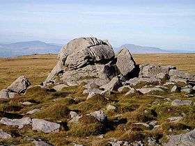 Ward's Stone is the highest point in the Forest of Bowland at 1,841 feet (561 m). | |
| Country | England |
|---|---|
| Counties | Lancashire, North Yorkshire |
| Districts | Ribble Valley, Lancaster, Wyre, Craven, Pendle, Preston |
| Rivers | Hodder, Wyre |
| Location | Northern England |
| Highest point | Ward's Stone |
| - elevation | 561 m (1,841 ft) |
| AONB founded | 1964 |
 The Forest of Bowland AONB shown (in green) with the district boundaries of Lancashire | |

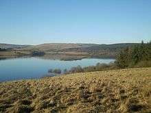
The Forest of Bowland, also known as the Bowland Fells, is an area of barren gritstone fells, deep valleys and peat moorland, mostly in north-east Lancashire, England with a small part in North Yorkshire (before 1974, some of the area was in the West Riding of Yorkshire). It was once described as the "Switzerland of England".[1][2]
The Forest of Bowland has been designated an Area of Outstanding Natural Beauty (AONB) since 1964. The Forest of Bowland AONB also includes a detached part known as the Forest of Pendle separated from the main part by the Ribble Valley, and anciently a forest with its own separate history. One of the best-known features of the area is Pendle Hill, which lies in Pendle Forest. There are more than 500 listed buildings and 18 scheduled monuments within the AONB.
Bowland survives as the north-western remainder of the ancient wilderness that once stretched over a huge part of England, encompassing the Forest of Bowland, Sherwood Forest (Nottinghamshire), the New Forest (Hampshire) and Savernake Forest (Wiltshire). While the Trough of Bowland (the valley and high pass connecting the Wyre (at Marshaw) and Langden Brook and dividing the upland core of Bowland into two main blocks) represents the area, to many, on account of its popularity, it is in fact only a small part of the wider Forest of Bowland area.
The hills on the western side of the Forest of Bowland attract walkers from Lancaster and the surrounding area. Overlooking Lancaster is Clougha Pike, the western-most hill. The hills form a large horseshoe shape with its open end facing west. Clockwise from Lancaster the hills are Clougha Pike (413 m or 1,355 ft), Grit Fell (468 m or 1,535 ft), Ward's Stone (561 m or 1,841 ft), Wolfhole Crag (527 m or 1,729 ft), White Hill (544 m or 1,785 ft), Whins Brow (476 m or 1,562 ft), Totridge (496 m or 1,627 ft), Parlick (432 m or 1,417 ft), Fair Snape Fell (510 m or 1,670 ft), Bleasdale Moor (429 m or 1,407 ft), and Hawthornthwaite Fell (478 m or 1,568 ft). Considerable areas of the Bowland fells were used for military training during the Second World War, and there are still unexploded bombs in some areas.
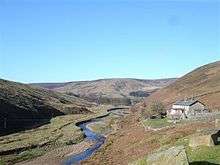
The area contains the geographic centre of Great Britain which is close to the Whitendale Hanging Stones, around four miles (6 km) north of Dunsop Bridge. The historical extent of Bowland Forest is divided into two large administrative townships, Great Bowland (Bowland Forest High and Bowland Forest Low) and Little Bowland (Bowland-with-Leagram), but the modern-day AONB covers a much larger area.
History
A region of the British kingdom of Rheged, Bowland was absorbed into Northumbria in the 7th century. In turn, as Northumbrian influence waned, the westernmost areas of Bowland became part of Amounderness, a territory forged by the Norse hold Agmundr, a vassal of Eowils, Halfdan and Ingwaer, co-kings of Jorvik, in the early 10th century.
In 926, Amounderness was annexed by Aethelstan, king of the West Saxons, as a spoil of war. In 934, he granted it to Wulfstan I, Archbishop of York. According to Aethelstan's grant, Amounderness at that time stretched "from the sea along the Cocker to the source of that river, from that source straight to another spring which is called in Old English, "Dunshop", thus down the riverlet to the Hodder, in the same direction to the Ribble and thus along that river through the middle of the channel to the sea".[3] As such, Amounderness encompassed a significant portion of western and south-western Bowland.
Ekwall thus describes the eastern boundary of Amounderness as "being formed by the fells on the Yorkshire border";[4] a description which places the ancient boundary firmly within the modern-day Forest of Bowland. While it is difficult to pinpoint Dunshop, the confluence of the rivers Dunsop and Hodder at Dunsop Bridge seems a likely locale, situated as it is close to the eastern mouth of the Trough of Bowland whose Grey Stone marks the line of the pre-1974 county boundary.
Contrary to the popular histories, the origins of the name "Bowland" have nothing to do with archery ("the land of the bow") or with mediaeval cattle farms or vaccaries (Old Norse, buu-, farmstead). The name derives from the Old Norse boga-/bogi-, meaning a "bend in a river". It is a 10th-century coinage used to describe the topography of the Hodder basin, with its characteristic meandering river and brooks.
The Domesday Bogeuurde is an instance of this usage – the placename thought to designate Barge Ford (formerly known as Boward), a ford that sits on the wide, pronounced bend of the Hodder at its confluence with Foulscales Brook, due south-west of Newton.
Before the Norman Conquest, Bowland was held by Tostig, son of Godwin, Earl of Wessex. However, as feudal entities, the Forest and Liberty of Bowland were created by William Rufus sometime after Domesday and granted to his vassal Roger de Poitou, possibly to reward Poitou for his role in defeating the Scots army of Malcolm III in 1091–92. In all likelihood, it was this grant that subsumed the eastern portion of Amounderness into the Lordship of Bowland for the first time.
By the end of the 11th century, the Forest and Liberty came into the possession of the De Lacys, Lords of Pontefract. In 1102, along with the grant of the adjacent fee of Clitheroe and further holdings in Hornby and Amounderness, they came to form the basis of what became known as the Honor of Clitheroe.
In 1311, the Honor of Clitheroe was subsumed into the Earldom of Lancaster. Between 1351 and 1661, it was administered as part of the Duchy of Lancaster. By the late 14th century, Bowland comprised a Royal Forest and a Liberty of ten manors spanning eight townships and four parishes and covered an area of almost 300 square miles (800 km2) on the historic borders of Lancashire and Yorkshire. The manors within the Liberty were Slaidburn (Newton-in-Bowland, West Bradford, Grindleton[5]) Knowlmere, Waddington, Easington, Bashall Eaves, Mitton, Withgill (Crook), Leagram, Hammerton and Dunnow (Battersby) .[6] Pendle Forest was also part of the Honor of Clitheroe, but administered as part of the Forest of Blackburnshire, entirely in Lancashire.
In 1661, the 28 manors contained within the former Honor of Clitheroe, including the Forest and Liberty of Bowland, were granted by the Crown to General George Monck as part of the creation of the Dukedom of Albermarle. Monck had been a key figure in the restoration of Charles II.[7] The Lordship of Bowland then descended through the Montagu, Buccleuch and Towneley families.
Bowbearers of the Forest of Bowland have been appointed since the 12th century. A Bowbearer was originally a noble who acted as ceremonial attendant to the Lord of Bowland, latterly the king, by bearing (carrying) his hunting bow, but over the centuries the Bowbearer's role underwent many changes. In April 2010 it was reported that the current 16th Lord of Bowland had revived the office of Bowbearer and appointed Robert Parker the first Bowbearer of the Forest in almost 150 years.[8][9]
The Forest of Bowland had its own forest courts – woodmote and swainmote – from early times. These appear to have been abandoned in the 1830s around the time of Peregrine Towneley’s acquisition of the Bowland Forest Estate. The halmote court at Slaidburn was disbanded following the abolition of copyhold by the Law of Property Act in 1922. General forest law in Britain was finally repealed by statute in 1971, more than 900 years after its introduction by the Normans. The original Bowland Forest courts appear to have been held at Hall Hill near Radholme Laund before moving to Whitewell sometime in the 14th century.
St Hubert, the patron saint of hunting, is also patron saint of the Forest of Bowland and has a chapel dedicated to him in Dunsop Bridge.[10] This chapel was founded by Richard Eastwood of Thorneyholme, land agent to the Towneley family. Eastwood was the last known Bowbearer of the Forest of Bowland. An acclaimed breeder of racehorses and shorthorn cattle, he died in 1871 and is buried at St Hubert's.
Ecology
The name "forest" is used in its traditional sense of "a royal hunting ground", and rather than being covered by trees, much of the land is heather moorland and blanket bog. In the past wild boar, deer, wolves, wild cats and game roamed the forest. It is an important area for grouse shooting. The Abbeystead estate holds the record for the biggest grouse bag in a day; when on 12 August 1915, 2,929 birds were shot by eight guns (shooters).[11]
Protected areas
38,940.5 acres (15,759 ha) of the Bowland Fells is designated a Site of Special Scientific Interest.[12] The area is internationally important for its upland bird populations and under the Habitats Directive "Bowland Fells" has been designated a Special Protection Area (designated especially for breeding merlin and hen harrier).[13]
Hen harriers
The hen harrier is the symbol of the AONB.[14] In the Forest of Bowland and other upland areas, the hen harrier is under threat from illegal persecution.[15] None bred in England in 2013.[16] The RSPB takes the view that licensing of driven grouse shooting is necessary so that, for example, crimes committed on estates managed for shooting should result in the withdrawal of their right to operate.
Nests on United Utilities land in the Forest of Bowland have been protected by volunteers. In 2014 it was announced that the Forest of Bowland would be one of the SPAs included in a European Union LIFE project to ensure a sustainable future for Hen harriers in England and Scotland.[17] The project aims to work constructively with landowners and the shooting community.[18]
Geography and geology
Caves in the area include Hell Hole, Whitewell Cave and Whitewell Pot.
Museum and visitor centre
The Bowland Visitor Centre is located in Beacon Fell Country Park in the AONB. It is managed by Lancashire County Council Countryside Service and provides visitors with information about the AONB and surrounding countryside.
There is a display on the ecology of the Forest of Bowland in Clitheroe Castle Museum.[19]
Events
The Bowland Challenge was a fundraising event held in 2006–11 (excluding 2010) in which teams of walkers navigated around a series of grid references over a ten-hour period. It raised funds for the Bowland Pennine Mountain Rescue Team.[20]
In culture
- There is a Forest of Bowland Suite by Lakeland composer Christopher Gibbs (b. 1938).[21]
- W. G. Rigby's children's tale The Ring of Tima (1998) is set in the Forest of Bowland.
- The Dark Legend Dossier by James Churchill is set in the town of Worton, located in the fictional 'Mender Vale.' The precise location of the town is never given but it is described as being 'north of Clitheroe' and some 7½ miles east of the M6 motorway.
- Jane Routh's 2014 collection of poetry Falling Into Place is set in the Forest of Bowland.[22]
See also
References
- ↑ Clitheroe Advertiser & Times, 5 August 1938
- ↑ "Keeping up traditions of beautiful Bowland". Lancashire Evening Post. 22 April 2010.
- ↑ Dorothy Whitelock, English Historical Documents, c. 500–1042 (Eyre & Spottiswoode: London 1955), pp. 504–8
- ↑ Eilert Ekwall, The Place-names of Lancashire (Manchester University Press: Manchester 1922)
- ↑ Grindleton Village website
- ↑ Forest of Bowland official website
- ↑ Thomas Dunham Whitaker, "An History of the Original Parish of Whalley and Honor of Clitheroe" (Routledge & Sons: Manchester 1872)
- ↑ "First Bowbearer of the Forest appointed for 150 years". Clitheroe Advertiser. 15 April 2010.
- ↑ "Lord of the Fells, Guardian of History" (PDF). Rural Life. November 2014.
- ↑ St Hubert's website
- ↑ Avery, Mark (2015). Inglorious Conflict in the Uplands. London: Bloomsbury. p. 59. ISBN 978 1 4729 1741 6.
- ↑ "Bowland Fells SSSI". Natural England. Retrieved 14 September 2015.
- ↑ Bowland Fells. JNCC.
- ↑ "Hen harrier". Retrieved 9 September 2016.
- ↑ "Rare male hen harriers 'missing' from Forest of Bowland". BBC. May 2015. Retrieved 1 September 2015.
- ↑ "Hen harrier on the brink of "extinction" in England". RSPB. 9 August 2013. Retrieved 28 September 2015.
- ↑ "New five-year Hen Harrier project launched". Raptor Persecution UK.
- ↑ "RSPB launches cross-border hen harrier protection project". BBC. 2014. Retrieved 14 July 2016.
- ↑ Clitheroe Castle Museum (guidebook). Ashworth, Susan. 2010
- ↑ "Bowland Challenge website", Retrieved 12 February 2014
- ↑ Christopher Gibbs, Lakeland composer
- ↑ the poetry business page on Falling Into Place by Jane Routh
External links
| Wikimedia Commons has media related to Forest of Bowland. |
- Forest of Bowland official site
- visitLancashire.com – Official Lancashire Tourism information, Walks and Cycle Routes in the Forest of Bowland
- Bowland Pennine Mountain Rescue Team
- Bowland Fell Runners
- Walks and Pubs in the Forest of Bowland
- Photographs of the Forest of Bowland
- Bowland Forest Gliding Club
| East of England | 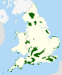 | |
|---|---|---|
| East Midlands | ||
| North East | ||
| North West | ||
| South East | ||
| South West | ||
| West Midlands | ||
| Yorkshire and Humber | ||
Coordinates: 53°57′N 2°35′W / 53.95°N 2.59°W