Hunza Valley
| Hunza | |
|---|---|
| Valley | |
| Time zone | PST (UTC+5) |

The Hunza (Burushaski and Urdu: ہنزہ) is a mountainous valley in the Gilgit–Baltistan region of Pakistan. The Hunza is situated in the extreme northern part of Pakistan.
History
Hunza was formerly a princely state bordering Uyghurstan also called Xinjiang (autonomous region of China) to the northeast and Pamir to the northwest, which survived until 1974, when it was finally dissolved by Zulfikar Ali Bhutto. The state bordered the Gilgit Agency to the south and the former princely state of Nagar to the east. The state capital was the town of Baltit (also known as Karimabad); another old settlement is Ganish Village. Hunza was an independent principality for more than 900 years. The British gained control of Hunza and the neighbouring valley of Nagar between 1889 and 1892 through a military conquest. The then Mir/Tham (ruler) Mir Safdar Ali Khan of Hunza fled to Kashghar in China and sought what would now be called political asylum. [1]
Mir/Tham
An account wrote by John Bidulf in his book 'Tribes of Hindukush'
| “ | The ruling family of Hunza is called Ayeshe (heavenly). The two states of Hunza and Nagar were formerly one, ruled by a branch of the Shahreis, the ruling family of Gilgit, whose seat of government was Nager. First muslim came to Hunza-Nagar Valley some 1000 years (At the time of Imam Islām Shāh 30th Imam Ismaili Muslims). After the introduction of Islam to Gilgit, married a daughter of Trakhan of Gilgit, who bore him twin sons, named Moghlot and Girkis. From the former the present ruling family of Nager is descended. The twins are said to have shown hostility to one another from birth. Thereupon their father, unable to settle the question of succession, divided his state between them, giving Girkis the north/west, and to Moghlot the south/east bank of the river.[2] | ” |

The traditional name for the ruler or Prince in Hunza was Tham (also Thom or Thum), which is also a respectful greeting used by the people of both Hunza and Nager who belong to the clan of Boorish. The Shin use the term Yeshkun for the Boorish.
| “ | Both Thams are also addressed as Soori, a title of respect. This appears to be the same [in meaning] as Sri, commonly prefixed to the names of Hindu princes in India, to denote their honour and prosperity. The Tham's wives are styled ghenish which is almost identical with the original Sanskrit word for mother, and their sons are called gushpoor.[3] | ” |
2010 landslide
In 2010, a landslide blocked the river and created Attabad Lake, which threatened 15,000 people in the valley below and has effectively blocked 27 km of the Karakoram Highway.[4]
Capital of Hunza
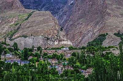
The first seat of power of the formerly Hunza State was Altit. Later it shifted to Baltit (modern-day Karimabad). Until the fall of princely state in 1974, Baltit served as political center of Hunza and hence its capital. Today, Baltit is one of the major tourist destinations in Hunza. The center of activities has however shifted to the nearby Aliabad, which is a commercial hub in the region and has most of the governmental infrastructure.
Geography
Hunza is divided into 3 geographic subdivisions:
Upper Hunza-Gojal Valley
Upper Hunza comprises the Gojal tehsil of Hunza District. The main towns, villages and valleys are:
- Gulmit
- Shishket / shishket lake
- Passu
- Sost
- Shimshal
- Jamalabad
- Gircha
- Wakhi
- Ghulkin
- Hussaini (older names Sisoni/Ghusani)
- Borith
- Chipursan
- Ghalapan
- Ispenj
- Khudaabad
- Khunjareb Pass
- Khyber
- Moorkhun
- Gircha
- Serteez
- Migar
- Misgar
- Raminj
- Kirmin
- Reshit Khill
- Shersabz
- Shishkat (now Nazeemabad)
- Shitmerg
- Yarzerech
- Zoodkhoon
Lower Hunza
Lower Hunza comprises the parts of Aliabad tehsil of Hunza District. The main towns, villages and valleys are:
- Nasirabad
- Hussainabad
- Khizerabad
- Khanaabad
Khanabad is a small hamlet in the mountains of Lower Hunza between Mayon and Nasir Abad on the Karakoram Highway in Pakistan. In 1902, eight families from Nasirabad came to the place (the old name was Jhok Das) and built water channel with the help of stones (without machines) through the mountains. Then Mir of Hunza sent 4 families from central Hunza also and they were also settled there. Now, after 111 years, the population of the village is around 1850 and the number of households is around 280.
Central Hunza
Central Hunza consists of the parts of Aliabad tehsil of Hunza District. The main towns, villages and valleys are:
- Aliabad
- Dourkhan
- Karimabad
- Altit
- Ahmedabad
- Burusho
- Ganish Village
- Garelt
- Hassanabad
- Murtazaabad
- Haiderabad
- Salmanabad
Climate

The temperature in May reaches a maximum of 45 °C (113 °F) and a minimum of 35 °C (95 °F); the October maximum is 27 °C (81 °F) and the minimum 14 °C (57 °F). Hunza's tourist season is generally from May to October, because in winter the Karakoram Highway is often blocked by the snow.
Transport
Today, the Karakoram Highway crosses Hunza, connecting Pakistan to China via the Khunjerab Pass, which was blocked by the Attabad Lake north of Hunza is reopend using PAK-China Friends Ship Tunnels in 2016. Travelling up the valley from the south, Hunza is to the left, and the former state of Nagar to the right of the Hunza River. Regular bus and van services operate between Gilgit and Central Hunza (Ganish Village, Aliabad and Karimabad) and also between Gilgit and Sost Gojal. PTDC Office at Gilgit, Sost and Islamabad arranges tours and transport for visitors. NATCO (Northern Area's Transport Co) runs a daily bus from Rawalpindi to Hunza.
Scenery
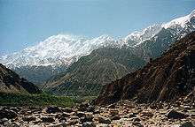
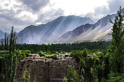
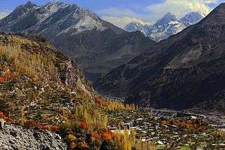
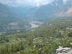
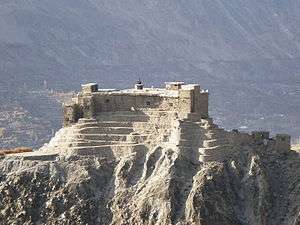
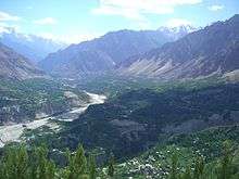
Several high peaks rise above 6,000 metres (20,000 ft) in the Hunza valley. The valley provides views of several tall mountains, including Rakaposhi 7,788 metres (25,551 ft), Ultar Sar 7,388 metres (24,239 ft), Bojahagur Duanasir II 7,329 metres (24,045 ft), Ghenta Sar 7,090 metres (23,261 ft), Hunza Peak 6,270 metres (20,571 ft), Darmyani Peak 6,090 metres (19,980 ft), and Bublimating (Ladyfinger Peak) 6,000 metres (19,685 ft). A watch tower is located in heart of Ganish Village, Baltit Fort stands on top of Karimabad whereas Altit Fort lies somewhat lower down the valley on another outcrop.
The valley is popularly believed to be the inspiration for the mythical valley of Shangri-la in James Hilton's 1933 novel Lost Horizon.
People of Hunza
The local languages spoken include Burushaski, Wakhi and Shina. The literacy rate of the Hunza valley is believed to be more than 40%.[5] Virtually every child is educated up to at least high school level.[5] The Life style of People of Hunza is very simple and they are considered to be very warm and welcoming.
Most of the inhabitants of Hunza are Ismaili Muslims, followers of His Highness Prince Karim Aga Khan IV, while in Ganish more than 65% are Shia Muslims.
The Hunza region is principally home to people of four ethnicities:
- The Lower Hunza area - from Khizerabad to Nasirabad is mainly inhabited by the Shinaki people who are Shina speakers.
- The Central Hunza area - from Murtazaabad to Attabad is mainly inhabited by Burushaski speakers, however, there is a centuries-old locally inhabiting community as well that is known as the 'Domaki' which lives in a village lying in the immediate vicinity of 'Baltit' called 'Mominabad'.
- The Upper Hunza area, known as Gojal - from Shiskat to Khunjerab is mainly populated by Wakhi speakers and burusho speakers.
Gallery
-

Nasirabad Valley Hunza - Rakaposhi View
-

Nasirabad Valley Hunza
-
Attabad Lake caused by a landslide in the valley on 4 January 2010.
-
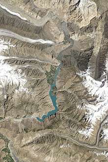
The lake on 3 August 2011.
-
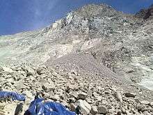
Closeup of the 2010 landslide
-

Women cross the Hunza River near Passu
-

Hunza Valley
-

Karimabad Hunza
-
Passu Gojal, Hunza
See also
- State of Hunza (former)
- Hunza–Nagar District
- Shamanism in Hunza
- Northern Areas (former)
- Silk Road transmission of Buddhism
- Karakoram Highway
- Karakoram Mountains
- Neelam Valley
- Kalasha Valley
- Kaghan Valley
- Nagar Valley
- Safar Hai Shart A travelogue show by Express News (Pakistan) made on modern day Hunza
References
- ↑ Valley, Hunza. "Hunza Valley". www.skardu.pk. Skardu.pk. Retrieved 23 November 2016.
- ↑ Tribes of the Hindoo Koosh by John Bidulph page 26
- ↑ Tribes of the Hindoo Koosh by John Bidulph Sang e meel publication page 30
- ↑ http://www.dawn.com/wps/wcm/connect/dawn-content-library/dawn/news/sci-tech/03-rising-water-threatens-villages-in-hunza-ss-03
- 1 2 Siddiqui, Shahid. "Hunza disaster and schools". Dawn (newspaper). Retrieved 6 July 2012.
- Kreutzmann, Hermann, Karakoram in Transition: Culture, Development , and Ecology in the Hunza Valley, Oxford University Press, 2006. ISBN 978-0-19-547210-3
- Leitner, G. W. (1893): Dardistan in 1866, 1886 and 1893: Being An Account of the History, Religions, Customs, Legends, Fables and Songs of Gilgit, Chilas, Kandia (Gabrial) Yasin, Chitral, Hunza, Nagyr and other parts of the Hindukush, as also a supplement to the second edition of The Hunza and Nagyr Handbook. And An Epitome of Part III of the author’s “The Languages and Races of Dardistan.” First Reprint 1978. Manjusri Publishing House, New Delhi.
- Lorimer, Lt. Col. D.L.R. Folk Tales of Hunza. 1st edition 1935, Oslo. Three volumes. Vol. II, republished by the Institute of Folk Heritage, Islamabad. 1981.
- Sidkey, M. H. "Shamans and Mountain Spirits in Hunza." Asian Folklore Studies, Vol. 53, No. 1 (1994), pp. 67–96.
- History of Ancient Era Hunza State By Haji Qudratullah Beg English Translation By Lt Col (Rtd) Saadullah Beg, TI(M)
- Wrench, Dr Guy T (1938), The Wheel of Health: A Study of the Hunza People and the Keys to Health, 2009 reprint, Review Press, ISBN 978-0-9802976-6-9, retrieved 12 August 2010
External links
| Wikimedia Commons has media related to Hunza Valley. |
 Hunza Valley travel guide from Wikivoyage
- Hunza Valley Page - Information Department Gilgit Baltistan Government