Hurricane Fefa
| Category 3 major hurricane (SSHWS/NWS) | |
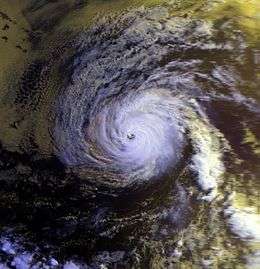 Hurricane Fefa over the open eastern Pacific | |
| Formed | July 29, 1991 |
|---|---|
| Dissipated | August 8, 1991 |
| Highest winds |
1-minute sustained: 120 mph (195 km/h) |
| Lowest pressure | 959 mbar (hPa); 28.32 inHg |
| Fatalities | None reported |
| Damage | Minimal |
| Areas affected | Big Island of Hawaii, Hawaiian Islands |
| Part of the 1991 Pacific hurricane season | |
Hurricane Fefa was a major Pacific hurricane of the 1991 Pacific hurricane season that despite causing minimal effects its name was removed from the list of tropical cyclone names. The sixth tropical storm, fourth hurricane, and second major hurricane of the season, the storm developed from a tropical wave on July 29 about 975 miles (1,575 km) south-southeast of Cabo San Lucas. It moved west-northwestward, and under generally favorable conditions it strengthened to attain peak winds of 120 mph (195 km/h) on August 2. Fefa turned to the west towards Hawaii, and slowly weakened until dissipating near the island of Hawaii.
The hurricane produced rough surf, moderate wind gusts, and locally heavy rainfall during its passage over Hawaii. No damages or deaths were reported. Two people were injured in the island of Hawaii due to lightning strikes from the storm.
Meteorological history

A westward-moving tropical wave exited the coast of Africa on July 17. It tracked across the unfavorable Atlantic Ocean and Caribbean Sea without development, and after crossing Central America, it entered the eastern Pacific Ocean on July 25. The cloud pattern and convection began to become better organized on July 28, and shortly thereafter a mid-level circulation developed. It continued to organize, and subsequent to the development of a low-level circulation it formed into Tropical Depression Seven-E while located about 975 miles (1,575 km) south-southeast of Cabo San Lucas on July 29.[1] Operationally, tropical cyclone advisories were not initiated until visible satellite images confirmed the low-level circulation twelve hours after the depression formed.[2]
Located over warm waters with fair upper level outflow,[2] the depression quickly intensified and attained tropical storm status twelve hours after forming.[1] Upon strengthening into a tropical storm, Fefa developed a curved cloud band over the southern and eastern portion of the center.[2] The storm slowly strengthened as it tracked west-northwestward, a motion due to the presence of a high-pressure ridge to its north.[3] Fefa initially strengthened slowly; on the day after it became a tropical storm the center was located on the western edge of the deep convection.[4] On July 31, convection began increasing over the center,[5] and it is estimated it intensified into a hurricane later that day while located about 710 miles (1,145 km) southwest of the southern tip of Baja California.[1]
Initially, Fefa was forecast to intensify slightly after reaching hurricane status to reach peak winds of 80 mph (130 km/h).[6] However, it quickly intensified after a large, ragged eye developed early on August 1.[7] On August 2, the eye organized further, and Fefa strengthened to attain a peak intensity of 120 mph (195 km/h) while located about 940 miles (1,510 km) west-southwest of Cabo San Lucas.[1] Based on higher Dvorak numbers, the hurricane could have peaked with winds stronger than 120 mph (195 km/h).[8] Fefa encountered cooler waters shortly after peaking in intensity, and subsequently began to weaken.[9] The hurricane gradually weakened as it turned more to the west, a change in motion due to building high pressures to its north, and on August 3 the winds of Fefa dropped to 85 mph (135 km/h)[8] due to cooler water and dry air.[10]
As Fefa turned more to the west, it paralleled the cooler waters, allowing the eye to remain distinct as the hurricane remained well-organized.[11] Despite moving over marginally warm sea surface temperatures and becoming involved with the Stratocumulus cloud field to its north, the hurricane restrengthened on August 4[12] to reach a secondary peak intensity of 105 mph (170 km/h) while located about 1,265 miles (2,070 km) east-southeast of Hilo, Hawai'i. After maintaining 105 mph (170 km/h) winds for about 18 hours, Fefa weakened slightly due to increasing wind shear from a cold-core trough as it entered the Central Pacific Hurricane Center area of responsibility. As the shear increased, the cyclone weakened more rapidly, and on August 6 it weakened to a tropical storm while located about 650 miles (1,060 km) east of the island of Hawaii.[8] Initially, forecasters predicted Fefa to turn to the northwest to the north of the Hawaiian Islands. However, the storm continued moving almost due westward as it steadily weakened. Aircraft reconnaissance flew into Fefa three times as it neared Hawaii. Late on August 7, Fefa weakened to a tropical depression a short distance of the island of Hawaii, and early on August 8 the depression began dissipating and degenerated into a tropical wave after moving onshore. The remnants tracked west-northwestward and passed south of the Hawaiian Islands until dissipating on August 9 to the northwest of Kauai.[13]
Impact

The prolonged westward track of Hurricane Fefa produced swells of up to 15 feet (4.5 m) in height. The swells hit eastward facing beaches along the island of Hawaii. The swells washed debris and sea water onto coastal roads near Punaluu Black Sand Beach, resulting in the roads being closed following the storm.[13] Southwestern Maui experienced rough surf, as well.[14] Despite being a weak tropical depression and a tropical wave while moving through the Hawaiian Islands, Fefa produced locally strong wind gusts of up to 50 mph (80 km/h) in the islands of Hawaii and Maui.[13]
Prior to moving across the island of Hawaii, strong thunderstorms developed in the northeastern portion of the remnant circulation of Fefa. The thunderstorms developed further as they moved over the slopes of Mauna Kea and Kohala. The thunderstorms produced heavy rainfall in areas, resulting in flash flooding in Kohala and Hamakua. Hurricane Fefa resulted in no known deaths. Lightning from the storm caused two injuries. A man in Hawaii Volcanoes National Park was hurt when lightning struck where he was walking. A man in Hilo was burnt when lightning moved through telephone wires.[13] The storm resulted in no reported damage.[15]
The name Fefa was removed after this storm and replaced with Felicia in the 1997 season. The reason for the name retirement is unknown, as the storm itself caused little damage. Possible reasons listed for the removal of the name are pronunciation ambiguity, a socially unacceptable meaning in another language, or because the storm name represented a significant human disaster.[16]
See also
References
- 1 2 3 4 Max Mayfield (1991). "Hurricane Fefa Tropical Cyclone Report Page 1". National Hurricane Center. Retrieved 2006-12-09.
- 1 2 3 Max Mayfield (1991). "Tropical Depression Seven-E Discussion One". National Hurricane Center. Retrieved 2006-12-09.
- ↑ Pasch (1991). "Tropical Storm Fefa Discussion Three". NHC. Retrieved 2006-12-09.
- ↑ Max Mayfield (1991). "Tropical Storm Fefa Discussion Six". NHC. Retrieved 2006-12-09.
- ↑ Rappaport (1991). "Tropical Storm Fefa Discussion Seven". NHC. Retrieved 2006-12-09.
- ↑ Gerrish (1991). "Hurricane Fefa Discussion Eight". NHC. Retrieved 2006-12-09.
- ↑ Avila (1991). "Hurricane Fefa Discussion Thirteen". NHC. Retrieved 2006-12-09.
- 1 2 3 Max Mayfield (1991). "Hurricane Fefa Tropical Cyclone Report Page 2". National Hurricane Center. Retrieved 2006-12-09.
- ↑ Avila (1991). "Hurricane Fefa Discussion Seventeen". NHC. Retrieved 2006-12-09.
- ↑ Avila (1991). "Hurricane Avila Discussion 21". NHC. Retrieved 2006-12-09.
- ↑ Avila (1991). "Hurricane Avila Discussion Twenty-Two". NHC. Retrieved 2006-12-09.
- ↑ Pasch (1991). "Hurricane Fefa Discussion Twenty-Three". NHC. Retrieved 2006-12-09.
- 1 2 3 4 Central Pacific Hurricane Center (1991). "The 1991 Central Pacific Tropical Cyclone Season". Retrieved 2006-12-09.
- ↑ Charles H. Fletcher III; Eric E. Grossman; Bruce M. Richmond; Ann E. Gibbs (2002). "Atlas of Natural Hazards in the Hawaiian Coastal Zone" (PDF). United States Geological Survey. Retrieved 2006-12-10.
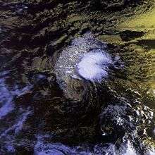
- ↑ Maura White (2006). "Oblique View of Hurricane Fefa, Pacific Ocean". JSC Digital Image Collection. Retrieved 2006-12-10.
- ↑ "Regional Association IV (North America, Central America and the Caribbean) Hurricane Operational Plan" (PDF). Tropical Cyclone Programme. Geneva, Switzerland: World Meteorological Organization. 2012-06-11. p. 9-6 TABLE IV: Names of Eastern North Pacific Ocean Storms Retired into Hurricane History. Archived from the original on 2013-02-02. Retrieved 2013-02-02. External link in
|work=(help)
External links
- National Hurricane Center archive on Hurricane Fefa
- Central Pacific Hurricane Center archive on Hurricane Fefa
Tropical cyclones of the 1991 Pacific hurricane season | ||
|---|---|---|
 | ||
| ||