Hurstpierpoint
| Hurstpierpoint | |
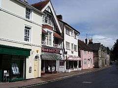 Hurstpierpoint High Street |
|
 Hurstpierpoint |
|
| OS grid reference | TQ279165 |
|---|---|
| – London | 39 miles (63 km) N |
| Civil parish | Hurstpierpoint and Sayers Common |
| District | Mid Sussex |
| Shire county | West Sussex |
| Region | South East |
| Country | England |
| Sovereign state | United Kingdom |
| Post town | HASSOCKS |
| Postcode district | BN6 |
| Dialling code | 01273 |
| Police | Sussex |
| Fire | West Sussex |
| Ambulance | South East Coast |
| EU Parliament | South East England |
| UK Parliament | Arundel and South Downs |
|
|
Coordinates: 50°56′00″N 0°11′07″W / 50.933288°N 0.185339°W
Hurstpierpoint is a village in West Sussex, England, 4 miles (6.4 km) southwest of Burgess Hill, and 1.5 miles (2.4 km) west of Hassocks railway station. Together with Sayers Common, it forms a civil parish with an area of 2029.88 ha and a population of 7,112.[1]
History
Toponymy
The name derives from 'Hurst', the Old English name for a wood, and 'Pierpoint' after the de Pierpoint family who arrived with William the Conqueror in 1066. The settlement was mentioned in the Domesday Book.[2] Throughout the centuries there have been several variants on the Hurstpierpoint name e.g. Herst (11th century); Herstperpunt (14th century); Perpondesherst (15th century).
The village is chiefly one long street running east and west and most of the buildings in it are of the 18th century or later.
Manors
The manor of Hurstpierpoint was held before the Norman Conquest by Earl Godwin, when it was an estate assessed at 41 hides, of which 3½ hides in the Rape of Pevensey and 19 hides in the Rape of Bramber were detached. After the Conquest, the remaining 18½ hides were held in 1086 by Robert de Pierpoint of William de Warenne. There was a church and 3 mills. The overlordship descended with the rape until the division after the death of Beatrice, Countess of Arundel, in 1439, when the 10 fees late of Robert de Pierpoint passed to the Duke of Norfolk. Subsequently the overlordship of Hurstpierpoint came into the hands of the Lords Bergavenny, and the manor was said in 1602 to have been held of their manor of Ditchling.
Charities
In Hurstpierpoint, there is a scouts HQ and a guides HQ, both of which consist of volunteers coming in on a set night to teach/help children/young adults with an activity. Scouts is for boys, and Guides is for girls (although boys and girls can go to both).
Geography
The village is built on a sandstone ridge,[3] 145 feet (44 m) above sea level, running east and west across the parish, on the road from Lewes to Albourne, and this is crossed in the centre of the village by Cuckfield Road which goes north to Cuckfield. The village is well known for the public school, Hurstpierpoint College, situated to the north east of the village.[4] It has a primary school (St Lawrence CEP) which is also well known as it has over 500 pupils. Hurstpierpoint is very close to the A23
Landmarks
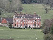
To the south of Hurstpierpoint is Danny House an Elizabethan Mansion[5] at the foot of Wolstonbury Hill which forms part of the South Downs.
It has some popular restaurants including The New Inn. It also has a brewery at the back of the White Horse.
Holy Trinity
The parish church [6]consists of a chancel with arcades of two bays, north chapel, south chapel (now organ chamber and vestry), nave, north and south transepts, north arcade and aisle of four bays, south arcade and aisle of five bays, and a north-west tower with an octagonal spire of stone. The base of the tower serves as a porch and there is a small porch to the north chapel. The nave has a clearstory.

The church was completely rebuilt from the designs of Sir Charles Barry in 1843–5,who most famously designed the Houses of Parliament
In 1854, the north chapel was added, and in 1874 the south chapel; the last has a dated foundation-stone in the east wall. The north transept has been fitted up as a chapel in memory of those who died in the War of 1914–18. The church which it replaced consisted of a chancel with a south chapel (the Danny chapel – see Danny House) of approximately equal dimensions, a nave with south aisle and north porch, and a west tower with a shingled spire. It had been almost rebuilt by a rector, John Urry, about 1420, but the tracery of the windows and most other ancient features had vanished under 'churchwarden improvements' before 1835.
A number of funeral monuments and fittings were preserved from the old church. The font is probably of c. 1200, but the heavy round bowl has been reworked and painted; the stem is plain; the base has a late 12th or early 13th century mould. Nearby, a broken mortar, brought from a local farmyard, has been set on a stem and base as if to represent a font. The enclosure around the font has turned balusters and moulded handrail of the 18th century and may have been the former communion rails.
In the east window of the south chapel are set fifteen medallions of German or Flemish glass of the 16th and 17th centuries; five are circular, the others oval; they mostly depict scenes from the Old and New Testaments and include a Nativity, and the placing of our Lord in the sepulchre. There are also four similar oval cartouches in the west window of the tower-porch, all collected and placed here by Canon Borrer in 1845.
In the south chapel is a much weathered recumbent effigy, 6 feet 8 inches (2.03 m) long, of a cross-legged knight in chain armour, of c. 1260; he bears his heater-shaped shield on his left arm and his right hand grasps the hilt of his sword. The feet rest against a lion.
At the west end of the north aisle is a much mutilated effigy of a knight of c. 1340 wearing a bascinet, mail gorget, close-fitting gypon with scalloped lower edge, a baudrick, and plate armour with knee-caps to the legs. The head rests on his helm, which has a lion crest; the feet also rest against a recumbent lion. The figure now rests on an altar-tomb against the north wall; the exposed south side has four quatrefoil panels each enclosing a plain shield, and the east end a single panel. The tomb is enclosed by an iron railing, 4 feet 10 inches (1.47 m) high, which has three diagonal standards treated with buttresses and with moulded and embattled caps and spikes for candles; these are of early 16th century date.
In the churchyard by the west wall are five tapering coffin lids of the 12th or 13th century with hollow chamfered edges. One shows faint traces of a raised cross.
Relaid in the pavement outside the west doorway are about 150 inlaid slip tiles, 6 inches (15 cm) square; of two patterns, one has a fish in a vesica piscis, four of the tiles forming a complete circular design, the other has a whorl of foliage forming part, probably, of a border pattern: late 13th or early 14th century, they are suffering from wear in their present position.
There are eight bells, of which 2 date from 1775, 3 from 1846, 1 from 1868, 1 from 1901 and 1 from 1953, the heaviest bell weighs 12cwt.[7] The church registers date from 1558.
There are 4 other churches in the village which are St Georges (not in use), Hurstpierpoint Methodist Church, St Luke's Catholic Church and Hurstpierpoint Evangelical Church.
Education
There is a primary school in the centre of the village (ST Lawrence School) which is a church primary school for children 4 – 11 years of age. On the northern edge of the village is located Hurstpierpoint College.
St Lawrence Fair
Every July the St Lawrence Fair takes place in Hurstpierpoint.[8] The fair was granted a royal charter in 1313 and is still an important event in the life of the village. The fair takes place on the first Saturday in July and begins with a procession of floats through the high street. These are made by groups such as playschools, primary schools, scouts and brownies and have a different theme each year. Other popular events of the day are the family fun run and the tug-o-war where the local pubs battle it out for a barrel of beer. In 2007 and 2008 it was won by the White Horse of Albourne Road. The fair is home to Harris fun fair and usually has a chair-o-plane amongst its rides as well as different stalls such as a coconut shy. Charities and businesses from around the area place stalls, tombolas and raffles around the centre, and on the other side is the beer tent and pig roast.
Sport
Hurstpierpoint is the home of Hurstpierpoint F.C.[9] who currently play in Sussex County League Division 3.
Hurstpierpoint is also home to a cricket club with the same name, which has several youth sides and two men's sides.
Hurstpierpoint is also home to Pink Flamingos Football Club, whose three Sunday sides make them one of the biggest Sunday league football clubs in southern England
Notable people
A notable local resident was Jimmy Hill,[10] legendary Match of the Day presenter and football player, manager and chairman, who was generous of his time for local events, clubs and societies until his death on 19 December 2015 aged 87. Greta Scacchi also lived in the village[11] until 2011 when a dispute with a neighbour led her to leave.[12] The agricultural chemist Sir John Saint (1898–1987) lived at Selwyn in St George's Lane.[13] The Olympic runner Frank Salvat also lived there until his death in 2013, and Brighton & Hove Albion winger Kazenga LuaLua lives in the village.[14]
Other notable persons are Saint Lawrence, which is the name of the local primary school and the previous name of Holy Trinity and Gwyneth Powell, best known for playing Mrs McCluskey in Grange Hill.
See also
References
| Wikimedia Commons has media related to Hurstpierpoint. |
- ↑ United Kingdom Census 2011. "Hurstpierpoint and Sayers Common CP (Parish)". neighbourhood.statistics.gov.uk. Retrieved 24 November 2016.
- ↑ "The Domesday Book Online - Sussex F-P".
- ↑ http://www.midsussex.gov.uk/media/2326/lca07pt3ca03hurstpierpointscarpfootslopes.pdf
- ↑ "Home - Hurstpierpoint College".
- ↑ "http://www.dannyhouse.org.uk/". External link in
|title=(help) - ↑ "Hurstpierpoint Holy Trinity Church of England - Homepage".
- ↑ Norris, John (2013). "Notes on the Church: Holy Trinity Hurstpierpoint" (PDF). p. 18. Retrieved 23 April 2016.
- ↑ "St Lawrence Fair History".
- ↑ "Club Website - Pitchero".
- ↑ Rees, Jasper (30 August 1998). "...and into extra time Profile: Jimmy Hill". The Independent. London. Retrieved 4 May 2010.
- ↑ The Argus, news, sport, events, jobs, homes for Brighton, Hove and Sussex
- ↑ Walker, Emily (5 February 2011). "Greta Scacchi's "driven out" of Sussex dream home". The Argus. Retrieved 14 May 2011.
- ↑ 'SAINT, Sir (Sidney) John', in Who Was Who 1981–1990 (London: A. & C. Black, 1991, ISBN 0-7136-3336-0)
- ↑ "Kazenga LuaLua 'Sparked Mass Newcastle Fight'".