Gurzuf
| Gurzuf Гурзуф | |||
|---|---|---|---|
| |||
.svg.png) Gurzuf Location of Hurzuf within the Crimea | |||
| Coordinates: 44°33′10″N 34°17′15″E / 44.55278°N 34.28750°ECoordinates: 44°33′10″N 34°17′15″E / 44.55278°N 34.28750°E | |||
| Country | Russia/Ukraine[1] | ||
| Republic | Crimea | ||
| Municipality | Yalta Municipality | ||
| Elevation | 30 m (100 ft) | ||
| Population (2014) | |||
| • Total | 8,933 | ||
| Time zone | MSK (UTC+4) | ||
| Postal code | 98640 — 98643 | ||
| Area code(s) | +380-654 | ||
| Former names | Gorsovium, Gorzubiti | ||
| Climate | Cfa | ||


Gurzuf or Hurzuf (Ukrainian: Гурзуф, Russian: Гурзу́ф, Crimean Tatar: Gurzuf, Greek: Γορζουβίται) is a resort-town (urban-type settlement) in Yalta Municipality of the Autonomous Republic of Crimea, a territory recognized by a majority of countries as part of Ukraine and incorporated by Russia as the Republic of Crimea. Population: 8,933 (2014 Census).[2]
It is located on the northern coast of the Black Sea. The site of a 6th-century fortress built by Justinian I and called by Procopius the fortress of the Gorzoubitai. The fortress was later restored by the Genoese who called the place Garzuni, Grasni, and Gorzanium, and appointed it the seat of a chief magistrate.[3] It was a former Crimean Tatar village, now a part of Greater Yalta. Alexander Pushkin visited Gurzuf in 1821 and ballet master Marius Petipa died here. The International Children Center Artek (former All-Union Young Pioneer camp Artek) is situated just behind the mount of Ayu-Dag (Bear Mountain). The World Organization of the Scout Movement's Eurasian Region is headquartered in the town.
Between Gurzuf and Mount Ayu-Dag is Cape Suuksu. At the top of the Cape is a tower, a medieval cemetery, and a small monument to Pushkin.
Gallery
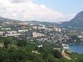 View of Gurzuf
 "Goddess of Night" fountain in Gurzuf
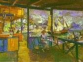 "Pier in Gurzuf" by Konstantin Korovin, 1914
References
- ↑ This place is located on the Crimean Peninsula, most of which is the subject of a territorial dispute between Russia and Ukraine. According to the political division of Russia, there are federal subjects of the Russian Federation (the Republic of Crimea and the federal city of Sevastopol) located on the peninsula. According to the administrative-territorial division of Ukraine, there are the Ukrainian divisions (the Autonomous Republic of Crimea and the city with special status of Sevastopol) located on the peninsula.
- ↑ Russian Federal State Statistics Service (2014). "Таблица 1.3. Численность населения Крымского федерального округа, городских округов, муниципальных районов, городских и сельских поселений" [Table 1.3. Population of Crimean Federal District, Its Urban Okrugs, Municipal Districts, Urban and Rural Settlements]. Федеральное статистическое наблюдение «Перепись населения в Крымском федеральном округе». ("Population Census in Crimean Federal District" Federal Statistical Examination) (in Russian). Federal State Statistics Service. Retrieved January 4, 2016.
- ↑ John Buchan Telfer. The Crimea and Transcaucasia. Forgotten Books, 2012. p.68.