Yalta Municipality
| Yalta City Municipality Ялтинский городской совет Ялтинська міська рада Yalta şeer şurası | |
|---|---|
| Municipality | |
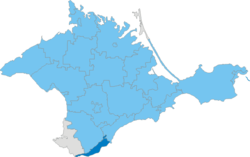 Location within Crimea | |
| Coordinates: 44°29′58″N 34°10′12″E / 44.49944°N 34.17000°ECoordinates: 44°29′58″N 34°10′12″E / 44.49944°N 34.17000°E | |
| Country | Russia/Ukraine[1] |
| Republic | Crimea |
| Capital | Yalta |
| Subdivisions |
List
|
| Area | |
| • Total | 283 km2 (109 sq mi) |
| Population (2014) | |
| • Total | 133,675 |
| • Density | 470/km2 (1,200/sq mi) |
| Time zone | MSK (UTC+3) |
| Dialing code | +7 3654 ¹ |
| Website | yalta.rk.gov.ru |
| (1) exсept for the town of Nikita - calling code +380-6560 | |
Yalta City Municipality (Russian: Я́лтинский городско́й сове́т; Ukrainian: Я́лтинська міська́ ра́да; Crimean Tatar: Yalta şeer şurası), officially "the territory governed by the Yalta city council", also known as Greater Yalta (Russian: Большая Ялта) is one of the 25 regions of the Autonomous Republic of Crimea, a territory recognized by a majority of countries as part of Ukraine and incorporated by Russia as the Republic of Crimea.
It is a resort region, located at the southern shore of Crimea – one of the most famous recreational territories of the former Soviet Union. Population: 133,675 (2014 Census).[2]
Administrative and municipal status
.png)
Within the framework of administrative divisions of Russia, Yalta is, together with a number of urban and rural localities, incorporated separately as the town of republican significance of Yalta—an administrative unit with the status equal to that of the districts.[3] As a municipal division, the town of republican significance of Yalta is incorporated as Yalta Urban Okrug.[4]
Within the framework of administrative divisions of Ukraine, Yalta is incorporated as the town of republican significance of Yalta.[5] Its governing body, Yalta miskrada (Yalta city council) was governing the territory what is described here as Yalta Urban Okrug.
Besides the cities of Yalta and Alupka, the region includes 21 towns and 9 villages which are organised into 7 town communities.
Former Crimean Tatar names which were officially changed in 1945-49 after the deportation of Crimean Tatars and are now used only by the Crimean Tatar community are mentioned in brackets.
|
|
Places of interest
- Nikitsky Botanical Garden (Nikita)
- International children's centre of Artek (Gurzuf)
- Livadia Palace (Livadiya)
- Vorontsov Palace (Alupka)
See also
References
- ↑ This place is located on the Crimean Peninsula, most of which is the subject of a territorial dispute between Russia and Ukraine. According to the political division of Russia, there are federal subjects of the Russian Federation (the Republic of Crimea and the federal city of Sevastopol) located on the peninsula. According to the administrative-territorial division of Ukraine, there are the Ukrainian divisions (the Autonomous Republic of Crimea and the city with special status of Sevastopol) located on the peninsula.
- ↑ Russian Federal State Statistics Service (2014). "Таблица 1.3. Численность населения Крымского федерального округа, городских округов, муниципальных районов, городских и сельских поселений" [Table 1.3. Population of Crimean Federal District, Its Urban Okrugs, Municipal Districts, Urban and Rural Settlements]. Федеральное статистическое наблюдение «Перепись населения в Крымском федеральном округе». ("Population Census in Crimean Federal District" Federal Statistical Examination) (in Russian). Federal State Statistics Service. Retrieved January 4, 2016.
- ↑ Law of the Republic of Crimea #35-ZRK
- ↑ Law of the Republic of Crimea #15-ZRK
- ↑ Чисельність наявного населення України (in Ukrainian). State Service of Statistics. Retrieved 8 August 2014.
 |
Bakhchisaray Raion | Bakhchisaray Raion | Alushta | |
| Balaklava Raion (Sevastopol) (Black Sea) |
|
(Black Sea) | ||
| ||||
| | ||||
| (Black Sea) | (Black Sea) | (Black Sea) |
| Raions | |||||||
|---|---|---|---|---|---|---|---|
| Municipalities | |||||||
| Cities | |||||||
| |||||||