Hyde Park (MBTA station)
HYDE PARK | |||||||||||||||||||||||||
|---|---|---|---|---|---|---|---|---|---|---|---|---|---|---|---|---|---|---|---|---|---|---|---|---|---|
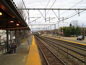 Looking inbound from the short high-level platforms | |||||||||||||||||||||||||
| Location |
1 Pingree Street Boston, Massachusetts 02136 | ||||||||||||||||||||||||
| Coordinates | 42°15′19″N 71°07′31″W / 42.2552°N 71.1252°WCoordinates: 42°15′19″N 71°07′31″W / 42.2552°N 71.1252°W | ||||||||||||||||||||||||
| Line(s) | |||||||||||||||||||||||||
| Platforms | 2 side platforms | ||||||||||||||||||||||||
| Tracks | 3 | ||||||||||||||||||||||||
| Connections |
| ||||||||||||||||||||||||
| Construction | |||||||||||||||||||||||||
| Parking |
121 spaces ($4.00 fee) 4 accessible spaces | ||||||||||||||||||||||||
| Bicycle facilities | 10 spaces | ||||||||||||||||||||||||
| Disabled access | Yes | ||||||||||||||||||||||||
| Other information | |||||||||||||||||||||||||
| Fare zone | 1 | ||||||||||||||||||||||||
| History | |||||||||||||||||||||||||
| Opened | c. 1850 | ||||||||||||||||||||||||
| Closed | November 3, 1979[1] | ||||||||||||||||||||||||
| Rebuilt | October 5, 1987[1] | ||||||||||||||||||||||||
| Previous names | Kenny's Bridge | ||||||||||||||||||||||||
| Traffic | |||||||||||||||||||||||||
| Passengers (2013) | 844 (daily inbound boardings)[2] | ||||||||||||||||||||||||
| Services | |||||||||||||||||||||||||
| |||||||||||||||||||||||||
Hyde Park is a regional rail station located on the Northeast Corridor in the Hyde Park section of Boston, Massachusetts. It is served by the MBTA Commuter Rail Providence/Stoughton Line and Franklin Line. Most service to Hyde Park is on Providence/Stoughton Line trains; only a small number of Franklin Line trains stop.
Hyde Park's two platforms serve the outer tracks of the Northeast Corridor, which is three tracks wide through the station. The station is officially located at 1 Pingree Street; however, both platforms are accessible from the River Street bridge via a pair of lengthy ramps. Both platforms are at track level for most of their lengths; however, short high-level platforms provide handicapped accessibility on both sides.
History
Boston and Providence Railroad
The Boston and Providence Railroad was built through Hyde Park in 1832-34, but a station was not immediately placed in the area, which was still largely unsettled. Henry Grew moved into the area in 1845 and others followed. Within a few years, "Kenny's Bridge" (at today's River Street) was an unofficial station stop. By 1852, a depot building had been built.[3] Hyde Park was incorporated as a town in 1868; the station was renamed to Hyde Park sometime before 1876.[4] Hyde Park served as a short turn turnback point for B&P trains from 1880 to 1899; before and after this period, the trains ran to Readville.[5]
Another station, currently known as Fairmount, is located in Hyde Park six blocks to the east. At various points in their histories, both stations were referred to both as "Hyde Park" and as "Fairmount".[6]
New Haven era
The Boston & Providence Railroad was acquired by the Old Colony Railroad in 1888, which in turn became part of the New York, New Haven and Hartford Railroad in 1893. On October 24, 1895, the 4:15 from Providence rear-ended the 5:18 local train from Sharon at Hyde Park at approximately 5:30 pm. The cause of the wreck was uncertain but may have been faulty signals.[7] The engine of the Providence-originating train was driven halfway through the trailing passenger car of the Sharon train, killing two people and injuring over twenty more. Among the injured were several members of a wedding party.[7]
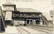
The New Haven built a large overhead station building adjacent to River Street in the early 1900s, replacing the earlier depot. The station was similar to other stations built by the railroad in and around New York City, rather than to geographically nearer stations.[8] Service to the station remained largely the same through most of the 20th century, with local trains stopping at the station while expresses bypassing it. The overhead station structure was demolished during the 1970s, leaving just staircases from River Street leading to bare platforms to serve passengers. The NYNH&H folded into Penn Central in 1969, who sold the line and station to the Massachusetts Bay Transportation Authority in 1973.[1] Conrail took over Penn Central in 1976 and the Boston & Maine Railroad was contracted to operate the southside commuter lines starting in March 1977, thus marking the sixth operator to run trains to Hyde Park.[1]
MBTA era
In November 1979, the station was closed for Southwest Corridor construction, while all Providence and Franklin trains were rerouted over the Fairmount Line.[1] During this time, the MBTA modernized the station with new ramps from River Street and mini-high platforms, making it one of the first MBTA stations to be retrofitted for full handicapped accessibility. The station reopened in October 1987 and has served Providence/Stoughton and Franklin line trains since.[1]
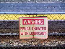
Crossing the tracks at Hyde Park is not only illegal but extremely dangerous, because Amtrak trains, as well as some express commuter trains, pass through the station without stopping. The blind curve to the north makes it difficult to know if a train is coming; moreover, trains may operate in either direction on any track without warning, and without regard to any normally intuitive current of traffic. (Franklin Line trains in both directions largely use the westernmost track, while most Amtrak trains use the center track.) To discourage trespassers, the fence between tracks is lubricated to make hopping it more difficult. Despite these measures, several trespassers have been struck at Hyde Park, with the most recent fatality in September 2011.[9]
Proposed Orange Line extension
Hyde Park is located in a densely populated neighborhood just eight miles from downtown Boston, making it a strong candidate for rapid transit service rather than conventional low-frequency commuter rail service. The 1945 Coolidge Commission Report recommended that an extension of the Orange Line south from Forest Hills be built to Dedham via West Roxbury rather than Hyde Park.[10] The 1966 Program for Mass Transportation recommended a bifurcated Orange Line, with one branch to West Roxbury or Hersey and another to Readville or Route 128 via Hyde Park.[11] Various reports over the next two decades continued to recommend various combinations of the extensions; however, due to cost, the 1987 relocation of the Orange Line to the Southwest Corridor was terminated at Forest Hills.[12] Hyde Park, Readville, and the Needham Line instead received limited upgrades like handicapped accessible platforms.
The extension is still periodically discussed. The 2004 Program for Mass Transportation listed an extension to Route 128 with intermediate stops at Mount Hope, Hyde Park, and Readville at a cost of $342.8 million. The extension was listed as low priority due to environmental issue with crossing the wetlands south of Readville, and because the corridor already had commuter rail service.[13]
Bus connections
Hyde Park is served by three MBTA Bus routes, which connect the station to several rapid transit stations and nearby neighborhoods:
- 32: Wolcott Square or Cleary Square - Forest Hills Station via Hyde Park
- 33: Dedham Line - Mattapan Station via River Street
- 50: Cleary Square - Forest Hills Station via Roslindale Square
References
- 1 2 3 4 5 6 Belcher, Jonathan (23 April 2012). "Changes to Transit Service in the MBTA district" (PDF). NETransit. Retrieved 17 May 2012.
- ↑ "Ridership and Service Statistics" (PDF) (14 ed.). Massachusetts Bay Transportation Authority. 2014. Retrieved 28 July 2014.
- ↑ J.B. Shields (1852). "Boston 1852". Ward Maps. Retrieved 17 May 2012.
- ↑ Comstock & Clinc Inc. (1876). "Hyde Park 1876". Ward Maps. Retrieved 17 May 2012.
- ↑ Humphrey, Thomas J.; Clark, Norton D. (1985). Boston's Commuter Rail: The First 150 Years. Boston Street Railway Association. p. 44. ISBN 9780685412947.
- ↑ Roy, John H. Jr. (2007). A Field Guide to Southern New England Railroad Depots and Freight Houses. Branch Line Press. pp. 146, 295. ISBN 9780942147087.
- 1 2 "Crushed in the Coaches: Many Passengers Injured in a Collision at Hyde Park, Mass.". New York Times. 24 October 1895. Retrieved 17 May 2012.
- ↑ Humphrey, Thomas J.; Clark, Norton D. (1986). Boston's Commuter Rail: Second Section. Boston Street Railway Association. p. 31. ISBN 9780938315025.
- ↑ Dwinell, Joe; Remal, Gary J. (16 September 2011). "Woman killed by train in Hyde Park". Boston Herald. Retrieved 17 May 2012.
- ↑ Boston Elevated Railway and Boston Department of Public Utilities (1945). "Boston Rapid Transit System & Proposed Extentions [sic] 1945 - Metropolitan Transit Recess Commission Air View". Wardmaps LLC. Retrieved 17 March 2013.
- ↑ MBTA planning staff (3 May 1966). "A Comprehensive Development Program for Public Transportation in the Massachusetts Bay Area: 1966". Massachusetts Bay Transportation Authority. p. V-9. Retrieved 17 March 2013.
- ↑ Central Transportation Planning Staff (15 November 1993). "The Transportation Plan for the Boston Region - Volume 2". National Transportation Library. Retrieved 17 March 2013.
- ↑ Central Transportation Planning Staff (January 2004) [May 2003]. "Chapter 5C: Service Expansion" (PDF). 2004 Program for Mass Transportation. Boston Metropolitan Planning Organization. p. 5C-83. Archived from the original (PDF) on 20 February 2012. Retrieved 17 March 2013.
External links
| Wikimedia Commons has media related to Hyde Park (MBTA station). |