Readville (MBTA station)
READVILLE | |||||||||||||||||||||||||||||||||
|---|---|---|---|---|---|---|---|---|---|---|---|---|---|---|---|---|---|---|---|---|---|---|---|---|---|---|---|---|---|---|---|---|---|
 Providence/Stoughton (left) and Franklin Line platforms at Readville | |||||||||||||||||||||||||||||||||
| Location |
1800 Hyde Park Avenue Boston, Massachusetts | ||||||||||||||||||||||||||||||||
| Coordinates | 42°14′18″N 71°08′01″W / 42.2382°N 71.1336°WCoordinates: 42°14′18″N 71°08′01″W / 42.2382°N 71.1336°W | ||||||||||||||||||||||||||||||||
| Line(s) |
Northeast Corridor Franklin Line Fairmount Line Dedham Branch (former) | ||||||||||||||||||||||||||||||||
| Platforms |
1 side platform (Fairmount Line) 2 side platforms (Franklin Line) 2 side platforms (Northeast Corridor; unused) | ||||||||||||||||||||||||||||||||
| Tracks |
1 each (Franklin Line and Fairmount Line) 3 (Northeast Corridor) | ||||||||||||||||||||||||||||||||
| Connections |
| ||||||||||||||||||||||||||||||||
| Construction | |||||||||||||||||||||||||||||||||
| Platform levels | 2 | ||||||||||||||||||||||||||||||||
| Parking |
354 spaces ($4.00 fee) 15 accessible spaces | ||||||||||||||||||||||||||||||||
| Disabled access | Yes | ||||||||||||||||||||||||||||||||
| Other information | |||||||||||||||||||||||||||||||||
| Fare zone | 2 | ||||||||||||||||||||||||||||||||
| History | |||||||||||||||||||||||||||||||||
| Opened |
1834 (Boston & Providence) 1853 (Midland Branch) | ||||||||||||||||||||||||||||||||
| Rebuilt | 1992 | ||||||||||||||||||||||||||||||||
| Electrified | Northeast Corridor only | ||||||||||||||||||||||||||||||||
| Previous names | Blue Hills (upper level) | ||||||||||||||||||||||||||||||||
| Traffic | |||||||||||||||||||||||||||||||||
| Passengers (2013 daily inbound averages) |
365 (Franklin Line)[1] 256 (Fairmount Line)[1] | ||||||||||||||||||||||||||||||||
| Services | |||||||||||||||||||||||||||||||||
| |||||||||||||||||||||||||||||||||
Readville is a passenger rail station located slightly northwest of Wolcott Square in the Readville section of the Hyde Park neighborhood of Boston, Massachusetts. It serves multiple lines on the MBTA (Massachusetts Bay Transportation Authority) Commuter Rail system, with access to the Fairmount Line and Franklin Line on separate platforms. Readville is the terminus of the Fairmount Line, although a small number of rush hour trains continue through the station to and from the Franklin Line. The station has platforms in place on the Northeast Corridor, but they are not used by Providence/Stoughton Line trains except during service disruptions.
Passenger service has run to Readville continuously since the Boston and Providence Railroad opened in 1834. Separate stations on two levels were consolidated by the New Haven Railroad around 1898. Until 1958, the railroad had its heavy maintenance facilities located in Readville 5-Yard to the west of the station. The station building burned down in 1983, but the MBTA built replacement platforms and ramps in 1992.
History
Early stations
The Boston and Providence Railroad was built through Readville starting in 1832, and passenger service on the main line and a branch to Dedham began in 1834. The Norfolk County Railroad built the Midland Division starting in 1853 from Islington to Boston through Readville, and full service began in July 1855.[2][3] The Midland Branch, also called the Dorchester Branch, connected the Norfolk County Railroad (which then ran to Blackstone, Massachusetts to Boston.[3] The Midland Division crossed the Boston & Providence on a high grade and bridge; there was initially no track connection between the two railroads.[4] The Norfolk County was acquired by the Boston, Hartford and Erie Railroad in 1868 and then to the New York and New England Railroad in 1875, becoming the latter's primary route into Boston. Readville served as a short turn turnback point for B&P trains from 1867 to 1880 and after 1899.[5]
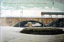
The Midland Branch station, located on the upper level closer to Wolcott Square, was originally known as Blue Hills after the nearby range of hills.[6] However, by 1888, it, too, was known as Readville.[4] Near the beginning of the 20th century, the two stations were consolidated as one under the New Haven. After the New York, New Haven and Hartford Railroad acquired the Boston & Providence in 1893 and the NY&NE in 1898, the two stations were consolidated. A connecting track was built in 1899 allowing trains from Franklin and beyond to run on the Northeast Corridor to Boston, and the two-story Readville depot was built to serve both levels on the station.[3][7] An under-track passage provided access to the southbound B&P platform and the NY&NE track area.
Dedham and Midland branches
The Dedham Branch briefly became an important piece of the New Haven's commuter system. Between 1926 and 1938, trains operated on a loop using the Dedham Branch and the B&P's West Roxbury Branch (part of which is now part of the Needham Line). In 1940, service to Dedham via West Roxbury was discontinued, leaving the Dedham Branch as the only rail access to Dedham.[3] However, traffic to Dedham continued to decline, and the last service (a single daily round trip) to Dedham via the Dedham Branch ended on April 21, 1967.[8] The MBTA purchased the abandoned right of way from Penn Central on January 27, 1973.[8]:330
The Midland Branch also declined in importance after the Franklin division was connected to the New Haven mainline in 1899. Through trains from Connecticut were redirected to the mainline at Readville, leaving only Franklin and Readville locals to use the Midland. Service on the line from Boston to Readville was discontinued in 1938; it returned in 1940, but ended more permanently in March 1944.[3] Through trains to Connecticut (discontinued in 1955) and commuter trains to Blackstone (discontinued April 24, 1966) and Franklin continued to use the section from Readville to Islington.[3][8]:329
MBTA era
From 1944 to 1979, the configuration of Readville was static: the two-story depot served the lower level (Northeast Corridor) tracks, while the elevated track to Franklin and beyond was served by a small shack with stairs to the lower level. Starting in 1979, construction of the Southwest Corridor necessitated closure of the main line between Back Bay and Forest Hills. From November 3, 1979 until October 5, 1987, all Franklin Line and Providence/Stoughton Line service ran to Boston on the Midland Division via Readville.[8]
The two-story station building was destroyed by a fire on June 11, 1983.[9] The building had been vacant since the early 1970s and was a frequent target of vandalism; the fire was judged to be of suspicious origin.[10] The MBTA did not replace the building, but handicapped-accessible platforms were installed in 1992 and were connected with footbridges.[11]
When Franklin and Providence/Stoughton service returned to the main line, service on the Midland had become popular enough to justify a continued shuttle service along the line from Boston to Fairmount. The Fairmount Shuttle was extended to Readville on November 30, 1987 as the Fairmount Line.[8] Since 1987, Providence/Stoughton Line service has run through Readville without making a station stop, even though there are platforms in place to allow such use.
The 1898-built bridge over the Northeast Corridor, now used by Franklin Line trains running via Fairmount, is planned for replacement. The span will be replaced with a prebuilt bridge in a single weekend with minimal impact to Amtrak and MBTA service on the Corridor, with the old abutments left in place as retaining walls. The design contract was awarded in 2012, and a construction contract was to be awarded in 2015.[12]
Proposed Orange Line extension
Readville is located in a densely populated neighborhood just nine miles from downtown Boston, making it a strong candidate for rapid transit service rather than conventional low-frequency commuter rail service. The 1945 Coolidge Commission Report recommended that an extension of the Main Line Elevated (now the Orange Line) south from Forest Hills be built to Dedham via West Roxbury rather than Hyde Park and Readville.[13] The 1966 Program for Mass Transportation recommended a bifurcated Orange Line, with one branch to West Roxbury or Hersey and another to Readville or Route 128 via Hyde Park.[14] Various reports over the next two decades continued to recommend various combinations of the extensions; however, due to cost, the 1987 relocation of the Orange Line to the Southwest Corridor was terminated at Forest Hills.[15] Hyde Park, Readville, and the Needham Line instead received limited upgrades, such as handicapped-accessible platforms.
The 2004 Program for Mass Transportation included an Orange Line extension to Route 128, with intermediate stops at Mount Hope, Hyde Park, and Readville at a cost of $342.8 million. The extension was listed as low priority due to environmental issues with crossing the wetlands south of Readville, and because the corridor already had commuter rail service.[16]
Station layout

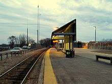
Readville has an unusual layout because it is built on the crossing of two rail lines. The Fairmount Line and Franklin Line each have a single track atop an embankment. The Fairmount Line has a single side platform, while the Franklin Line has two. The Fairmount Line track continues atop a bridge over the Northeast Corridor to join with the Franklin Line.[17] This connection is used by several trains each rush hour, allowing trains from the Franklin Line to avoid congestion in the crowded Southwest Corridor.
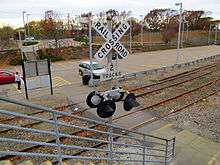
At ground level, the three-track Northeast Corridor runs through the station. There are two side platforms; however, Providence/Stoughton Line trains do not stop at Readville in regular service. The platforms are occasionally used during service disruptions when Fairmount Line service is not running or when trains cannot stop at Hyde Park.[18]
Next to the Franklin Line embankment, two abandoned tracks run to the former Dedham Branch and Readville 5-Yard.[17]
Readville station is fully handicapped accessible, although accessible routes are only available from the Hyde Park Avenue entrance.[1] Every platform includes a 1-car length ("mini-high") high-level platform, which allows passengers to board level with the train car floors. The platforms are all connected by a system of pedestrian bridges which include accessible ramps.
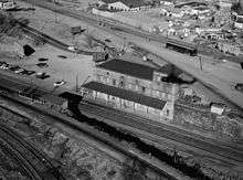
Railroad yards
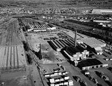
Readville station is bounded by several railroad yards which were mostly built in the first half of the 20th century. East of the station on the Fairmount Line is the Readville Interim Repair Facility, an MBTA commuter rail maintenance facility and layover yard.[1] Readville 1-Yard is an active CSX freight yard located south of the station, on tracks connecting the Fairmount Line to the Northeast Corridor. Additionally, there were formerly several yard tracks along the Northeast Corridor north of the station.[19]
West of the station, Readville 5-Yard lies south of the former Dedham branch. The 42-acre (17 ha) 5-Yard is split between Boston and Dedham, Massachusetts and was formerly owned and used by the New York, New Haven and Hartford Railroad, which had shops on the site until 1958. The Penn Central Railroad acquired the yard along with the rest of the New Haven in 1968; the property was transferred to Conrail on March 30, 1976, and to Amtrak a day later.[2] The MBTA acquired the yard from Amtrak on November 11, 1987 and used it to store railroad-related materials.[2] Site remediation for environmental contamination including lead, arsenic, and PAHs was completed in 2011.[20][21][22]
In March 2012, the MBTA announced that the contamination had been fully removed, and revealed plans to place solar panels in the west part of 5-Yard. The panels would be installed and maintained for at least 20 years by an outside contractor.[23] Bidding began in May 2012, with the stipulation that the solar array would be operational by the spring of 2013.[24] The contract was chosen in September 2012, with a revised completion date of October 2013.[25] In July 2013, MassDOT (the MBTA's parent agency) announced that construction would not begin until at least 2014 due to a state solar program reaching capacity earlier than expected.[26] As of January 2015, the installation was to occur in June 2015.[27]
Bus connections
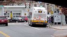
Readville has connections to two MBTA Bus routes:
- 32 Wolcott Square or Cleary Square – Forest Hills Station via Hyde Park Avenue
- 33 Dedham Line – Mattapan Station via River Street
The 32 route runs on Hyde Park Avenue to Wolcott Square, while the 33 runs on Readville Street just to the west.[28]
References
- 1 2 3 4 "Ridership and Service Statistics" (PDF) (14 ed.). Massachusetts Bay Transportation Authority. 2014. Retrieved 7 December 2015.
- 1 2 3 Earth Tech AECOM (5 November 2008). "Draft Supplemental Phase II/III and Revised Phase IV Remedy Implementation Plan (RIP)" (PDF). Massachusetts Bay Transportation Authority. Retrieved 4 July 2012.
- 1 2 3 4 5 6 Karr, Ronald Dale (1995). The Rail Lines of Southern New England. Branch Line Press. pp. 146–150; 295–298. ISBN 0942147022.
- 1 2 E. Robinson (1888). "Hyde Park 1888 Plate 09 – Readville". Atlas of Norfolk County, 1888. WardMaps LLC. Retrieved 8 July 2012.
- ↑ Humphrey, Thomas J. & Clark, Norton D. (1985). Boston's Commuter Rail: The First 150 Years. Boston Street Railway Association. p. 44. ISBN 9780685412947.
- ↑ Comstock & Cline (1876). "Hyde Park 1876". Atlas of Norfolk County, 1876. WardMaps LLC. Retrieved 8 July 2012.
- ↑ G.W. Bromley and Co. (1912). "Hyde Park 1912 Index Plate". Atlas of The City of Boston Ward 26 Hyde Park, 1912. WardMaps LLC. Retrieved 8 July 2012.
- 1 2 3 4 5 Belcher, Jonathan (27 June 2015). "Changes to Transit Service in the MBTA district 1964-2015" (PDF). NETransit. Retrieved 7 December 2015.
- ↑ "Index to photographs" (PDF). Northeast Railroad Corridor, Amtrak Route between RI/MA State Line & South Station, Boston, Suffolk County, MA. Historic American Engineering Record. Retrieved 10 August 2015.
- ↑ Hochman, Anndee (12 June 1983). "Fire destroys Readville depot". Boston Globe – via Proquest Historical Newspapers. (subscription required (help)).
- ↑ "MBTA Begins Upgrading Fairmount Line" (PDF). TRANSreport. Boston Metropolitan Planning Organization. May 2005. Archived from the original (PDF) on 9 December 2010. Retrieved 29 December 2012.
- ↑ "MBTA Shore Line Bridge Reconstruction Project". Massachusetts Bay Transportation Authority. Retrieved 7 December 2015.
- ↑ Boston Elevated Railway and Boston Department of Public Utilities (1945). "Boston Rapid Transit System & Proposed Extentions 1945 – Metropolitan Transit Recess Commission Air View". Wardmaps LLC. Retrieved 17 March 2013.
- ↑ MBTA planning staff (3 May 1966). "A Comprehensive Development Program for Public Transportation in the Massachusetts Bay Area: 1966". Massachusetts Bay Transportation Authority. p. V-9. Retrieved 17 March 2013.
- ↑ Central Transportation Planning Staff (15 November 1993). "The Transportation Plan for the Boston Region – Volume 2". National Transportation Library. Retrieved 17 March 2013.
- ↑ Central Transportation Planning Staff (January 2004) [May 2003]. "Chapter 5C: Service Expansion" (PDF). 2004 Program for Mass Transportation. Boston Metropolitan Planning Organization. p. 5C-83. Archived from the original (PDF) on 20 February 2012. Retrieved 17 March 2013.
- 1 2 Held, Patrick R. (2010). "Massachusetts Bay Colony Railroad Track Charts" (PDF). Johns Hopkins Association for Computing Machinery. Archived from the original (PDF) on 8 October 2013. Retrieved 7 December 2015.
- ↑ "Service Alerts: Providence/Stoughton Line: Upcoming". Massachusetts Bay Transportation Authority. 14 July 2014. Archived from the original on 15 July 2014. Retrieved 15 July 2014.
The outbound platform at Hyde Park will be closed due to bridge work between Hyde Park & Readville Stations on the Prov/Sto Line... During the weekdays listed below, all outbound trains that normally stop at Hyde Park will instead stop at Readville Station on the Providence/Stoughton Line
- ↑ United States Geographical Survey (1941). "Norwood Quadrangle NE". University of New Hampshire. Retrieved 8 July 2012.
- ↑ Mark Newell / AECOM (2011). "Phase IV Status Report #3 for Readville Yard 5" (PDF). Massachusetts Bay Transportation Authority. Retrieved 3 July 2012.
- ↑ "Readville 5-Yard Assessment and Remediation". Massachusetts Bay Transportation Authority. Retrieved 3 July 2012.
- ↑ "Readville 5 Yard Facility: Public Involvement Plan Meeting, November 5, 2008" (PDF). Massachusetts Bay Transportation Authority. 5 November 2008. Retrieved 3 July 2012.
- ↑ Young, Colin A. (27 March 2012). "MBTA wants solar companies to build plants at Wonderland in Revere and Readville Yard 5 in Dedham". Boston Globe. Retrieved 3 July 2012.
- ↑ Eisenstadter, Dave (5 April 2012). "MBTA to accept bids for solar array construction in Dedham". Wicked Local Dedham. Archived from the original on 19 November 2012. Retrieved 3 July 2012.
- ↑ Eisenstadter, Dave (14 September 2012). "Dedham property to be site of large MBTA solar array". Wicked Local Dedham. Archived from the original on 25 October 2012. Retrieved 15 September 2012.
- ↑ Eisenstadter, Dave (July 19, 2015). "Solar array delayed in Dedham". Boston Globe. Retrieved 7 December 2015.
- ↑ Donaghy, Michael (7 January 2015). "MBTA's Energy Management Program" (PDF). AEE New England. Retrieved 7 December 2015.
- ↑ "Readville Station Neighborhood Map" (PDF). Massachusetts Bay Transportation Authority. June 2012. Retrieved 7 December 2015.
External links
| Wikimedia Commons has media related to Readville (MBTA station). |
- MBTA – Readville
- Google Maps Street View: Hyde Park Avenue and Sprague Street entrances
- Historic American Buildings Survey entry from 1977 including photographs of Readville station and yards
| Subway lines (List of stations) |
| |||||||||||
|---|---|---|---|---|---|---|---|---|---|---|---|---|
| Commuter Rail lines (List of stations) |
| |||||||||||
| Bus routes (List of routes) | ||||||||||||
| Other services | ||||||||||||
| Component parts of system lines | ||||||||||||
| Capital projects |
| |||||||||||
| History |
| |||||||||||
| Other | ||||||||||||