Ilam, Iran
| Ilam ايلام | |
|---|---|
| city | |
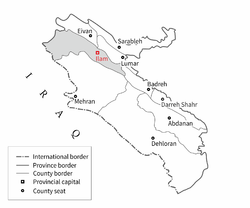 Location in the Ilam province | |
 Ilam Location in Iran | |
| Coordinates: 33°38′15″N 46°25′22″E / 33.63750°N 46.42278°ECoordinates: 33°38′15″N 46°25′22″E / 33.63750°N 46.42278°E | |
| Country | Iran |
| Province | Ilam |
| County | Ilam |
| Bakhsh | Central |
| Population (2006) | |
| • Total | 155,289 |
| Time zone | IRST (UTC+3:30) |
| • Summer (DST) | IRDT (UTC+4:30) |
| Website |
www |
Ilam (Persian: ايلام; also Romanized as Īlām and Elām)[1] is a city in and the capital of Ilam Province, Iran and the third biggest kurdish city in Iran. At the 2006 census, its population was 155,289, in 34,549 families.[2]
The Kabir Kuh mountain range lies east of the city. From the west it borders Iraq. The city is populated by Kurds and its primary language is Kurdish.
Architecture
Like many other regions of Iran the architecture in Ilam includes traditional and contemporary periods. Although easy access to fossil fuels and electricity may have aided the transition in Iranian architecture in other regions of Iran from its traditional to modern styles, in Ilam the increasing population has also played a role.
The Governor Castle, Falahaty Mansion and The Mirgholam Castle are examples of some surviving traditional buildings in Ilam. The courtyard dwelling is the main type of the buildings of this period. This type of building was accepted as the main building type over all Iran for both climatic and cultural reasons. Brick is the main constructional material in these buildings. The passive thermal techniques indicated for the Iranian traditional buildings are commonly used in these buildings.
The Governor Castle of Ilam was built in type of courtyard. Adding shade and moisture by using green landscape, high trees and a pond, were the main passive techniques used in this building to reduce the temperature in summer. The Mirgholam Castle of Ilam presents a classic Iranian courtyard. The garden and the pound were the main elements of this type of buildings. The Falahaty Mansion used a pitched roof as it was regular beside the flat roofs in the traditional buildings in Ilam earlier.[3]
Climate
Ilam is situated in the cold mountainous region of Iran at a height of 1,319 metres (4,330 ft) above mean sea level. It is located in the west of Iran at a latitude of 33° 38´ north and longitude of 46° 26´ east. Although this city is surrounded by mountains, its climate is also affected by deserts from the west and the south. This region presents a highly variable annual weather profile. Heavy showers or snow in the winter and dusty, brutally hot, dry weather in the summer are normal for this region.[4] Monthly rainfalls have been as high as 352.1 millimetres (13.86 in) in March 1974, whilst daily rainfalls have reached 86 millimetres or 3.39 inches on 26 February 1991. Temperatures have ranged from a high of 47.0 °C or 116.6 °F on 20 August, 1975 to a low of −15.0 °C or 5.0 °F on 5 February 1974.
Ilam’s climate is classed under the Köppen climate classification as a Mediterranean climate (Csa) with continental influences.
| Climate data for Ilam (1967 to 2005) | |||||||||||||
|---|---|---|---|---|---|---|---|---|---|---|---|---|---|
| Month | Jan | Feb | Mar | Apr | May | Jun | Jul | Aug | Sep | Oct | Nov | Dec | Year |
| Record high °C (°F) | 23.1 (73.6) |
21.0 (69.8) |
25.0 (77) |
30.2 (86.4) |
37.5 (99.5) |
40.0 (104) |
43.0 (109.4) |
47.0 (116.6) |
40.0 (104) |
35.2 (95.4) |
32.0 (89.6) |
27.5 (81.5) |
47.0 (116.6) |
| Average high °C (°F) | 9.0 (48.2) |
10.2 (50.4) |
14.0 (57.2) |
19.8 (67.6) |
26.3 (79.3) |
32.4 (90.3) |
35.8 (96.4) |
35.3 (95.5) |
31.6 (88.9) |
24.9 (76.8) |
17.1 (62.8) |
11.7 (53.1) |
22.4 (72.3) |
| Average low °C (°F) | −0.3 (31.5) |
0.6 (33.1) |
3.7 (38.7) |
8.6 (47.5) |
13.8 (56.8) |
18.1 (64.6) |
21.2 (70.2) |
20.8 (69.4) |
17.3 (63.1) |
12.3 (54.1) |
6.3 (43.3) |
1.9 (35.4) |
10.4 (50.7) |
| Record low °C (°F) | −14 (7) |
−15 (5) |
−11 (12) |
−3 (27) |
3.0 (37.4) |
7.0 (44.6) |
8.0 (46.4) |
8.0 (46.4) |
7.5 (45.5) |
1.9 (35.4) |
−6.2 (20.8) |
−12 (10) |
−15 (5) |
| Average precipitation mm (inches) | 117.5 (4.626) |
103.9 (4.091) |
123.1 (4.846) |
70.1 (2.76) |
26.1 (1.028) |
0.5 (0.02) |
0.6 (0.024) |
0.3 (0.012) |
1.1 (0.043) |
26.2 (1.031) |
80.3 (3.161) |
94.8 (3.732) |
644.5 (25.374) |
| Average precipitation days (≥ 1.0 mm) | 9 | 8 | 10 | 7 | 4 | 0 | 0 | 0 | 0 | 3 | 6 | 8 | 55 |
| Average relative humidity (%) | 66 | 62 | 57 | 49 | 38 | 27 | 25 | 25 | 26 | 38 | 51 | 61 | 44 |
| Source: Iranian Meteorological Organisation (archived)[5] | |||||||||||||
Colleges and universities
Ilam contains the following universities:
- Ilam University of Medical Sciences
- University of Ilam
- Islamic Azad University of Ilam
- Safir Danesh
- Farhangian University, Shahid Modares Campus of Ilam (Men) and Imam Jafar -e- Sadiqh Campus of Ilam (Women)
References
- ↑ Ilam, Iran can be found at GEOnet Names Server, at this link, by opening the Advanced Search box, entering "-3067203" in the "Unique Feature Id" form, and clicking on "Search Database".
- ↑ "Census of the Islamic Republic of Iran, 1385 (2006)". Islamic Republic of Iran. Archived from the original (Excel) on 2011-11-11.
- ↑ J Khodakarami. Achieving Thermal Comfort in Iranian Hospitals. Cardiff University, PhD Thesis, 2008
- ↑ J Khodakarami and I Knight. Required and Current Thermal Conditions for Occupants in Iranian Hospitals. HVAC&R Research, Vol. 14, Number 2, March 2008, pp 175-194
- ↑ "FORM 1: STATION ILAM". Iranian Meteorological Organization. Retrieved 2011-11-18.
External links
| Wikimedia Commons has media related to Ilam. |
- Farshid Sāmāni, Ilam, the Sleeping Beauty, in Persian, Jadid Online, 26 May 2009: .
• Discovering Ilam, in English, Jadid Online, 22 October 2009, .
• Photo gallery, containing 25 photographs with informative captions in English: .
| Counties and cities | 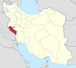 | |||||||||||||||||||||||||||||||||||
|---|---|---|---|---|---|---|---|---|---|---|---|---|---|---|---|---|---|---|---|---|---|---|---|---|---|---|---|---|---|---|---|---|---|---|---|---|
| Sights |
| |||||||||||||||||||||||||||||||||||
| populated places | ||||||||||||||||||||||||||||||||||||