Ilkeston Junction and Cossall railway station
Coordinates: 52°58′43″N 1°17′42″W / 52.97861°N 1.29500°W
| Ilkeston Junction and Cossall | |
|---|---|
| Location | |
| Place | Ilkeston |
| Area | Borough of Erewash |
| Operations | |
| Original company | Midland Railway |
| Pre-grouping | Midland Railway |
| Post-grouping | London Midland and Scottish Railway |
| History | |
| 6 September 1847 | First station partially opened as Ilkeston Junction |
| 1 August 1858 | Fully opened |
| 2 May 1870 | Replaced by new Ilkeston station |
| 1 July 1879 | Renamed Ilkeston Junction |
| 1 December 1890 | renamed Ilkeston Junction and Cossall |
| 2 January 1967 | Station closed[1] |
| Disused railway stations in the United Kingdom | |
|
Closed railway stations in Britain A B C D–F G H–J K–L M–O P–R S T–V W–Z | |
|
| |
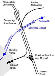
Ilkeston Junction and Cossall railway station was a railway station which served the town of Ilkeston in Derbyshire, England. It was opened in 1847 by the Midland Railway on the Erewash Valley Line at the junction of a short branch to the town itself.
The station became known locally as Ilkeston Junction, and when first built it was literally in the middle of nowhere, with no road leading from it to either Cossall or Ilkeston. Passengers would use farm tracks and the canal towpath to reach its isolated location.[2]
In 1870 a proper road ('Station Road' or 'Station Street') was completed to the station from Ilkeston, the original station closing in that year after completion of a new station further north.[2] The new station opened on 2 May 1870; originally named Ilkeston, it was renamed Ilkeston Junction on 1 July 1879, and Ilkeston Junction and Cossall on 1 December 1890.[1]
It carried a shuttle service to Ilkeston Town railway station which was never particularly popular since the GNR provided a direct main line service.[3] Some services were also provided to Nottingham and Chesterfield.[4] Since the latter passed through the north curve of the junction, they were unable to call at the station. The same was true of Nottingham trains when they ran on the short-lived branch between Bennerley Junction and Basford.
In the Grouping of all lines (into four main companies) in 1923 the station became part of the London, Midland and Scottish Railway .
The branch closed in 1960 (although passenger traffic had ceased by the late 1940s)[2] and the tracks were lifted, with the junction station finally closing to all traffic on 2 January 1967.[1]
Since then there have been several proposals for a new station on the Erewash Line in more or less the same location, the latest of which (in 2012) seems fairly likely to come about.[5] A new Ilkeston railway station is scheduled to open in 2016.
Ilkeston is often quoted in the press as being 'the largest town in England without a railway station'.[6]

New station fund
As part of the new station fund set out in March 2013, Ilkeston, Pye Corner and Lea Bridge were narrowed down as the three most likely stations to open or reopen, with the final announcement being made in May.[7][8] Work started in summer 2014 on site clearance work to construct new station.
References
- 1 2 3 Butt, R. V. J. (1995). The Directory of Railway Stations: details every public and private passenger station, halt, platform and stopping place, past and present (1st ed.). Sparkford: Patrick Stephens Ltd. p. 126. ISBN 1-8526-0508-1. OCLC 60251199.
- 1 2 3 Shaw, G & Miller, P, (2012) Railway Tales - Ilkeston and District in the Age of Steam, Ilkeston: Ilkeston & District Local History Society
- ↑ Kingscott, G., (2007) Lost Railways of Derbyshire, Newbury: Countryside Books
- ↑ Anderson, P.H., (1985 2nd. ed.) Forgotten Railways Part 2: The East Midlands, Trowbridge: David and Charles (distributor)
- ↑ BBC News: Funds sought for Ilkeston railway station
- ↑ BBC East Midlands Today
- ↑ "Fresh Start for Franchising". Department for Transport. 26 March 2013. Retrieved 1 April 2013.
- ↑ "Ilkeston could get new £5m railway station". 26 March 2013. Retrieved 1 April 2013.