In Ghar
| In Ghar إن غار | |
|---|---|
| Commune and town | |
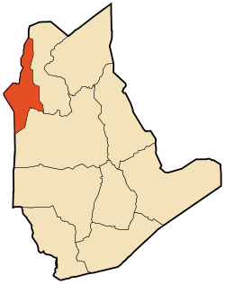 Location of In Ghar commune within Tamanrasset Province | |
 In Ghar Location of In Ghar within Algeria | |
| Coordinates: 27°6′11″N 1°54′37″E / 27.10306°N 1.91028°ECoordinates: 27°6′11″N 1°54′37″E / 27.10306°N 1.91028°E | |
| Country |
|
| Province | Tamanrasset |
| District | In Ghar (coextensive) |
| Government | |
| • PMA Seats | 7 |
| Area | |
| • Total | 28,969 km2 (11,185 sq mi) |
| Elevation | 258 m (846 ft) |
| Population (2008)[1] | |
| • Total | 11,225 |
| • Density | 0.39/km2 (1.0/sq mi) |
| Time zone | CET (UTC+01) |
| Postal code | 11210 |
| ONS code | 1103 |
In Ghar (Arabic: عين غار, lit. Cave spring) is a town and commune, coextensive with the district of In Ghar, in Tamanrasset Province, Algeria. According to the 2008 census it has a population of 11,225,[1] up from 8,059 in 1998,[2] with an annual growth rate of 3.4%.[1] Its postal code is 11210 and its municipal code is 1103.
Geography
In Ghar lies at an elevation of 258 metres (846 ft) on a flat plain in the Sahara Desert of southern Algeria. An oasis lies to the east of the town; it is extensively used for agriculture.
Climate
In Ghar has a hot desert climate (Köppen climate classification BWh), with long, extremely hot summers and short, very warm winters, little to no precipitation throughout the year, as well as permanent sunshine and clear skies.
| Climate data for In Ghar (In Salah station) | |||||||||||||
|---|---|---|---|---|---|---|---|---|---|---|---|---|---|
| Month | Jan | Feb | Mar | Apr | May | Jun | Jul | Aug | Sep | Oct | Nov | Dec | Year |
| Average high °C (°F) | 21.6 (70.9) |
25.1 (77.2) |
28.6 (83.5) |
33.2 (91.8) |
38.6 (101.5) |
44.1 (111.4) |
46.4 (115.5) |
45.5 (113.9) |
41.9 (107.4) |
35.1 (95.2) |
27.1 (80.8) |
21.9 (71.4) |
34.09 (93.38) |
| Daily mean °C (°F) | 14.3 (57.7) |
17.6 (63.7) |
21.0 (69.8) |
25.2 (77.4) |
30.4 (86.7) |
35.9 (96.6) |
37.7 (99.9) |
37.2 (99) |
33.8 (92.8) |
27.4 (81.3) |
20.1 (68.2) |
14.9 (58.8) |
26.29 (79.32) |
| Average low °C (°F) | 7.1 (44.8) |
10.0 (50) |
13.3 (55.9) |
17.1 (62.8) |
22.1 (71.8) |
27.6 (81.7) |
29.2 (84.6) |
28.8 (83.8) |
25.8 (78.4) |
19.7 (67.5) |
13.0 (55.4) |
7.8 (46) |
18.46 (65.22) |
| Average precipitation mm (inches) | 3.7 (0.146) |
3.5 (0.138) |
1.2 (0.047) |
1.6 (0.063) |
0.5 (0.02) |
0.1 (0.004) |
0.0 (0) |
0.5 (0.02) |
0.2 (0.008) |
1.2 (0.047) |
0.5 (0.02) |
2.7 (0.106) |
15.7 (0.619) |
| Average relative humidity (%) | 41.3 | 35.0 | 27.1 | 23.8 | 20.8 | 17.7 | 15.6 | 16.8 | 21.9 | 29.9 | 35.8 | 41.9 | 27.3 |
| Source #1: NOAA (1964-1990)[3] | |||||||||||||
| Source #2: climatebase.ru (humidity)[4] | |||||||||||||
Transportation
In Ghar lies on the northern side of the N52 national highway which connects the town to Aoulef and Reggane to the west and In Salah to the east.
Education
3.5% of the population has a tertiary education, and another 22.5% has completed secondary education.[5] The overall literacy rate is 84.2%, and is 91.4% among males and 76.1% among females.[6]
Localities
The commune is composed of eight localities:[7]
- In Ghar
- Laksar
- Tourfine
- Chouiter
- Lahdeb
- Akbour
- Miliana
- Sebkha
- Ez Zaouia
References
- 1 2 3 "Population: Wilaya de Tamanrasset" (PDF) (in French). Office National des Statistiques Algérie. Retrieved 30 May 2013.
- ↑ "Algeria Communes". Statoids. Retrieved 8 March 2013.
- ↑ "Climate Normals for In Salah". Retrieved 31 May 2013.
- ↑ "In-Salah, Algeria". Climatebase.ru. Retrieved 31 May 2013.
- ↑ "Structure relative de la population résidente des ménages ordinaires et collectifs âgée de 6 ans et plus selon le niveau d'instruction et la commune de résidence." (PDF) (in French). Office National des Statistiques Algérie. Retrieved 30 May 2013.
- ↑ "Taux d'analphabétisme et taux d'alphabétisation de la population âgée de 15 ans et plus, selon le sexe et la commune de résidence ." (PDF) (in French). Office National des Statistiques Algérie. Retrieved 30 May 2013.
- ↑ "Décret n° 84-365, fixant la composition, la consistance et les limites territoriale des communes. Wilaya de Tamanghasset" (PDF) (in French). Journal officiel de la République Algérienne,. 19 December 1984. p. 1496. Archived from the original (PDF) on 2 March 2013 or before. Retrieved 2 March 2013. Check date values in:
|archive-date=(help)
 |
Adrar Aougrout (Adrar) |
Ghardaïa El Goléa (Ghardaïa) |
Ouargla | |
| Aoulef (Adrar) | |
In Salah Illizi | ||
| ||||
| | ||||
| Akabli (Adrar) | Tin Zaouatine | Arak In Amguel Tamanrasset |
| Tamanrasset District |  | |||||||
|---|---|---|---|---|---|---|---|---|
| In Salah District | ||||||||
| Tazrouk District | ||||||||
| Abalessa District | ||||||||
| In Ghar District | ||||||||
| Tin Zaouatine District | ||||||||
| In Guezzam District | ||||||||