Ouargla
| Ouargla وَارْڨْرن / ورقلة ورجلان | |
|---|---|
| City | |
 | |
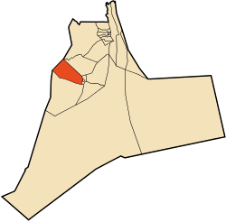 Location of Ouargla commune within Ouargla Province | |
 Ouargla Location of Ouargla within Algeria | |
| Coordinates: DZ 31°57′N 5°19′E / 31.950°N 5.317°ECoordinates: DZ 31°57′N 5°19′E / 31.950°N 5.317°E | |
| Country |
|
| Province | Ouargla Province |
| District | Ouargla District |
| Elevation | 219 m (719 ft) |
| Population (2008)[1] | |
| • City | 133,024 |
| • Urban | 191,136 |
| Time zone | CET (UTC+1) |
| Postal code | 30000 |
Ouargla (Berber: Wargren or Wargla, Arabic: ورجلان، ورقلة, old Berber name: Wareglan) is the capital city of Ouargla Province in the Sahara Desert in southern Algeria. It has a flourishing petroleum industry and hosts one of Algeria's universities, the University of Ouargla.[2] The commune of Ouargla had a population of 133,024 in the 2008 census,[1] up from 112,339 in 1998,[3] and an annual population growth rate of 1.7%.[1] However, including the commune of Rouissat, found in Ouargla's urban area, gives a total population of 191,136.[1]
Historical Ouargla
According to Ibn Khaldun the town was founded by Banu Wargla who, accompanied by sections of the Maghrawa and Banu Ifran, left the Tlemcen region and founded Ouargla. These Berbers of Ouarghla then embraced Ibadi doctrines, which later made the town an attractive refuge for the citizens of Tahert.
In 11th century, Banu Hilal, an Arab tribe living between Nile and Red Sea, settled in Tunisia, Tripolitania (western Libya) and Constantinois (eastern Algeria) which was Ouargla party.
Modern Ouargla
The city was a significant tourist attraction until the civil unrest during the 1990s. Many tourists chose to shop for sand roses at souk l'ehjar, the old rock market. The souq, or market, had many traditional shops filled with antiquities, traditional crafts, and local items - from dresses to stuffed lizards. The area across from these shops was used to display sand roses, mineral specimens, of all sizes and shapes. The market has gone through a renovation process. However many criticized this renovation, feeling it destroyed the historical character of souk l'ehjar and the area.
Not far from souk l'ehjar is the old groceries market, or the Sunday market as the called by the locals. It is also located in the centre of the old city, La Kasbah. At its centre lies the original old market, shaped as a circle split into small arcs. The central circular structure is now used as a meat market, and around this are rows of grocers and farmers with stalls displaying their produce, with all sorts of fruits and vegetables.
Next to the old groceries market lie the two oldest mosques of the city, "al-Masjid al-Atiq" which literally means "the old mosque," and the old Ibadhi mosque. The old Ibadhi mosque was "home" to one of the most renowned Islamic scholars of the city, Taleb et-Tayeb.
Some of Ouargla's population speak the Wargli language, which is part of the Zenati languages subgrouping of the Northern Berber languages.[4] There are Wargli speakers in N'Goussa as well.
Climate
Ouargla has a hot desert climate (Köppen climate classification BWh) with long, extremely hot summers and short, warm winters. Averages high temperatures in summer are consistently over 40 °C (104 °F) during nearly 4 months (June, July, August and September) to reach a maximum of around 45 °C (113 °F) in July. Averages low temperatures in summer are also very high, and are above 27 °C (82.4 °F) and routinely above 30 °C (86 °F) during the hottest month. The absolute highest temperature ever recorded in the city is 53.5 °C (128.3 °F). Average annual rainfall is around 45 mm (1.78 in) and summers are especially dry.[5]
| Climate data for Ouargla (1981-2010) | |||||||||||||
|---|---|---|---|---|---|---|---|---|---|---|---|---|---|
| Month | Jan | Feb | Mar | Apr | May | Jun | Jul | Aug | Sep | Oct | Nov | Dec | Year |
| Average high °C (°F) | 18.1 (64.6) |
20.9 (69.6) |
26.0 (78.8) |
30.0 (86) |
34.9 (94.8) |
40.3 (104.5) |
43.3 (109.9) |
42.5 (108.5) |
37.3 (99.1) |
31.4 (88.5) |
22.7 (72.9) |
19.2 (66.6) |
30.55 (86.98) |
| Daily mean °C (°F) | 11.3 (52.3) |
13.6 (56.5) |
18.0 (64.4) |
22.3 (72.1) |
27.4 (81.3) |
32.5 (90.5) |
35.5 (95.9) |
34.9 (94.8) |
30.1 (86.2) |
24.3 (75.7) |
16.8 (62.2) |
12.4 (54.3) |
23.5 (74.3) |
| Average low °C (°F) | 4.7 (40.5) |
6.8 (44.2) |
10.8 (51.4) |
15.1 (59.2) |
19.8 (67.6) |
24.7 (76.5) |
27.7 (81.9) |
27.3 (81.1) |
23.2 (73.8) |
17.2 (63) |
10.0 (50) |
6.0 (42.8) |
16.11 (61) |
| Average precipitation mm (inches) | 12.4 (0.488) |
1.0 (0.039) |
5.0 (0.197) |
1.8 (0.071) |
11.6 (0.457) |
4.1 (0.161) |
0.5 (0.02) |
0.3 (0.012) |
5.5 (0.217) |
4.4 (0.173) |
8.8 (0.346) |
2.8 (0.11) |
58.2 (2.291) |
| Average precipitation days | 1.4 | 0.3 | 1.0 | 0.7 | 0.8 | 0.5 | 0.3 | 0.2 | 1.1 | 1.2 | 1.6 | 0.5 | 9.6 |
| Source: Meteo-Climat[6] | |||||||||||||
Music
Peter Chatman, known as Memphis Slim, a great piano blues musician and boogie woogie all star, composed and performed a boogie-woogie instrumental tune named 'Ouargla' in 1971. On the track, he was accompanied by Michel Denis on drums. The piece pays tribute to the Ouargla oasis, which was a famous and popular 'hang out' in the late 1960s and early 1970s.
Localities
The commune is composed of 15 localities:[7]
- Mekhadma
- Beni Thour
- Ville de Ouargla
- Saïd Otba Est
- Saïd Otba Ouest
- Ba Mendil
- Bouameur
- Bour El Haïcha
- Sidi Amrane
- Gharbouz
- Sidi Boughoufala
- Melala Ksar
- Hassi Miloud
- Zone d'Activité
- Delalha(Sidi Amrane)
See also
References
- 1 2 3 4 "Population: Ouargla Wilaya" (PDF) (in French). Office National des Statistiques Algérie. Retrieved 24 February 2013.
- ↑ University of Ouargla, Algeria
- ↑ "Algeria Communes". Statoids. Retrieved 8 March 2013.
- ↑ "Tagargrent". Ethnologue. Retrieved 2 March 2013.
- ↑ https://datamarket.com/data/set/1loo/average-monthly-temperatures-across-the-world#!ds=1loo!1n6s=76.3js&display=line&hidden=2
- ↑ "moyennes 1981/2010". Meteo-Climat-Bhz. Retrieved 17 February 2016.
- ↑ "Décret n° 84-365, fixant la composition, la consistance et les limites territoriale des communes. Wilaya d'El Oued" (PDF) (in French). Journal officiel de la République Algérienne,. 19 December 1984. p. 1550. Archived from the original (PDF) on 2 March 2013 or before. Retrieved 2 March 2013. Check date values in:
|archive-date=(help)
External links
 |
Touggourt El Hadjira N'Goussa |
Sidi Khouiled Hassi Ben Abdellah El Oued |
| |
| Ghardaia | |
Ain Beida | ||
| ||||
| | ||||
| Rouissat | Hassi Messaoud |
Capital: Ouargla | ||
| Ouargla District | 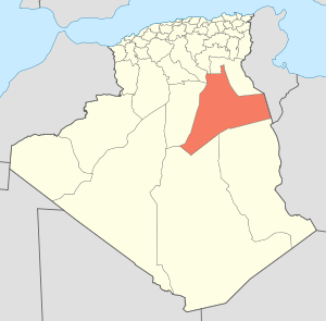 | |
| El Borma District | ||
| El Hadjira District | ||
| Hassi Messaoud District | ||
| Mégarine District | ||
| N'Goussa District | ||
| Sidi Khouïled District | ||
| Taïbet District | ||
| Témacine District | ||
| Touggourt District | ||