Adrar, Algeria
| Adrar | |
|---|---|
| City | |
|
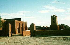
Buildings in Adrar | |
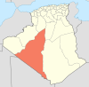
_location_map.svg.png) Location of Adrar commune within Adrar Province | |
 Adrar Location of Adrar within Algeria | |
| Coordinates: 27°52′N 0°17′W / 27.867°N 0.283°WCoordinates: 27°52′N 0°17′W / 27.867°N 0.283°W | |
| Country |
|
| Province | Adrar Province |
| District | Adrar District |
| Area | |
| • Total | 633 km2 (244 sq mi) |
| Elevation | 258 m (846 ft) |
| Population (2008)[1] | |
| • Total | 64,781 |
| • Density | 100/km2 (270/sq mi) |
| Time zone | CET (UTC+1) |
| Area code(s) | 0101 |
| Climate | BWh |
Adrar (Berber: Adrar, ⴰⴷⵔⴰⵔ; Arabic: أدرار) is the administrative capital of Adrar Province, the second largest province in Algeria. The commune is sited around an oasis in the Tuat region of the Sahara Desert. According to a 2008 census it has a population of 64,781,[1] up from 43,903 in 1998,[2] with an annual growth rate of 4.0%.[1]
Adrar is mainly an agricultural town, characterized by its traditional irrigation system, the Foggara.
Geography
Adrar lies at an elevation of 258 metres (846 ft) above sea level. A large oasis lies to the southwest of the town; this oasis lies in the Tuat region, a string of oases running from Bouda in the north to Reggane in the south. A vast area of sand dunes, the Erg Chech, lies to the west, while a large rocky plateau, the Tademaït, lies to the east.
Climate
Adrar has a hot desert climate (Köppen climate classification BWh), with long, hot summers and short, warm winters, and averages just 15 millimetres (0.59 in) of rainfall per year. Summer temperatures are consistently high as they commonly approach 40 °C (106 °F). temperatures at night are still hot at around 27 °C (81 °F). Even in early May or in late September, daytime temperatures can to 45 °C (113 °F). Adrar experiences the same kind of desert heat as Death Valley, California during summertime. Winter nights can be chilly and frost is by no means unknown but the days are pleasantly warm, sunny and dry.[3] During the summer, the Sahara region of Algeria is the source of a scorching, sometimes dusty and southerly wind called the Sirocco. These winds parch the plateaus of northern Algeria up to 40 days and reach the Tell coastal region for as many as 20 days.[4]
| Climate data for Adrar | |||||||||||||
|---|---|---|---|---|---|---|---|---|---|---|---|---|---|
| Month | Jan | Feb | Mar | Apr | May | Jun | Jul | Aug | Sep | Oct | Nov | Dec | Year |
| Record high °C (°F) | 31.2 (88.2) |
36.0 (96.8) |
40.7 (105.3) |
43.8 (110.8) |
49.8 (121.6) |
48.9 (120) |
51.0 (123.8) |
49.8 (121.6) |
46.8 (116.2) |
43.5 (110.3) |
36.0 (96.8) |
31.8 (89.2) |
51.0 (123.8) |
| Average high °C (°F) | 20.6 (69.1) |
24.5 (76.1) |
28.0 (82.4) |
32.1 (89.8) |
36.7 (98.1) |
42.5 (108.5) |
45.0 (113) |
44.3 (111.7) |
40.0 (104) |
33.1 (91.6) |
26.1 (79) |
20.9 (69.6) |
32.8 (91) |
| Daily mean °C (°F) | 12.4 (54.3) |
16.0 (60.8) |
19.4 (66.9) |
23.6 (74.5) |
28.1 (82.6) |
33.6 (92.5) |
36.0 (96.8) |
35.4 (95.7) |
31.6 (88.9) |
25.0 (77) |
18.2 (64.8) |
12.9 (55.2) |
24.3 (75.7) |
| Average low °C (°F) | 4.1 (39.4) |
7.5 (45.5) |
10.7 (51.3) |
15.1 (59.2) |
19.4 (66.9) |
24.7 (76.5) |
26.9 (80.4) |
26.6 (79.9) |
23.2 (73.8) |
16.8 (62.2) |
10.2 (50.4) |
4.9 (40.8) |
15.8 (60.4) |
| Record low °C (°F) | −4.2 (24.4) |
−2.0 (28.4) |
0.5 (32.9) |
4.8 (40.6) |
8.9 (48) |
15.2 (59.4) |
18.2 (64.8) |
20.0 (68) |
15.2 (59.4) |
6.0 (42.8) |
−1.5 (29.3) |
−4.1 (24.6) |
−4.2 (24.4) |
| Average precipitation mm (inches) | 2.3 (0.091) |
1.3 (0.051) |
2.6 (0.102) |
4.1 (0.161) |
0.3 (0.012) |
0.1 (0.004) |
0.0 (0) |
0.2 (0.008) |
0.2 (0.008) |
1.5 (0.059) |
0.6 (0.024) |
1.4 (0.055) |
14.6 (0.575) |
| Average precipitation days (≥ 0.1 mm) | 0.4 | 0.4 | 0.2 | 0.2 | 0.1 | 0.0 | 0.0 | 0.3 | 0.2 | 0.4 | 0.7 | 0.7 | 3.6 |
| Average relative humidity (%) | 52 | 52 | 40 | 34 | 30 | 28 | 26 | 29 | 36 | 48 | 59 | 57 | 42 |
| Mean monthly sunshine hours | 269.7 | 257.1 | 310.0 | 318.0 | 325.5 | 333.0 | 344.1 | 328.6 | 288.0 | 279.0 | 261.0 | 263.5 | 3,577.5 |
| Mean daily sunshine hours | 8.7 | 9.1 | 10.0 | 10.6 | 10.5 | 11.1 | 11.1 | 10.6 | 9.6 | 9.0 | 8.7 | 8.5 | 9.8 |
| Source #1: NOAA[5] | |||||||||||||
| Source #2: Deutscher Wetterdienst (extremes, humidity and sun)[6] | |||||||||||||
Culture
The settlement in the region (formerly known as Tuat) is quite ancient and the area provides for several different cultures and includes several historic monuments. This intermingling gave birth to a body of traditions and of cultural and hand-crafted practices that are still present today in the life of its inhabitants translating into a wealth of the folklore and cultural heritage.
Transportation
Touat Cheikh Sidi Mohamed Belkebir Airport (or simply Adrar Airport)[7] is located 10 kilometers away from center of the city. Airlines include Air Algérie flight to Algiers, Bordj Badji Mokhtar, Oran and Ouargla in addition to Tassili Airlines flights to In Aménas.
Adrar is on the N6 national highway, which leads north to Béchar and south to Reggane and Timiaouine.
Demographics
| Year | Population[1][2][8] |
|---|---|
| 1936 | 800 |
| 1966 | 13,300 |
| 1987 | 28,600 |
| 1998 | 43,903 |
| 2008 | 64,781 |
Education
9.2% of the population has a tertiary education, and another 19.8% has completed secondary education.[9] The overall literacy rate is 84.1%, and is 89.9% among males and 78.1% among females (the second highest among all the communes in the province).[10]
Localities
As of 1984, the commune was composed of the following eight localities:[11]
- Adrar
- Adgha
- Ouguedim
- Barbaa
- Ouled Oungal
- Ouled Ouchen
- Ouled Ali
- Tililane
- Meraguen
References
- 1 2 3 4 "Population: Wilaya d'Adrar" (PDF) (in French). Office National des Statistiques Algérie. Archived from the original (PDF) on 16 December 2011. Retrieved 29 June 2013.
- 1 2 "Algeria Communes". Statoids. Retrieved 8 March 2013.
- ↑ The Times Books World Weather Guide, E.A Pearce and C.G. Smith, TIMES BOOKS, The New York Times Book Co., Inc.
- ↑ The World Book Encyclopedia. Chicago: Scott Fetzer Co., 2007.
- ↑ "Adrar Climate Normals 1961–1990". National Oceanic and Atmospheric Administration. Retrieved 21 October 2016.
- ↑ "Klimatafel von Adrar / Algerien" (PDF). Baseline climate means (1961-1990) from stations all over the world (in German). Deutscher Wetterdienst. Retrieved 21 October 2016.
- ↑ "Touat Cheikh Sidi Mohamed Belkebir Airport". OurAirports. Retrieved 29 June 2013.
- ↑ populstat.info Archived March 3, 2016, at the Wayback Machine.
- ↑ "Structure relative de la population résidente des ménages ordinaires et collectifs âgée de 6 ans et plus selon le niveau d'instruction et la commune de résidence." (PDF) (in French). Office National des Statistiques Algérie. Archived from the original (PDF) on 13 November 2011. Retrieved 30 May 2013.
- ↑ "Taux d'analphabétisme et taux d'alphabétisation de la population âgée de 15 ans et plus, selon le sexe et la commune de résidence ." (PDF) (in French). Office National des Statistiques Algérie. Archived from the original (PDF) on 13 November 2011. Retrieved 30 May 2013.
- ↑ "Décret n° 84-365, fixant la composition, la consistance et les limites territoriale des communes. Wilaya d'Adrar" (PDF) (in French). Journal officiel de la République Algérienne. 19 December 1984. p. 1472. Archived from the original (PDF) on 14 October 2013. Retrieved 30 June 2013.
 |
Béchar El Mansour |
El Bayadh Sebaa Meraguen |
Ghardaïa Aougrout Tililane |
|
| Melouka | |
In Salah (Tamanrasset) | ||
| ||||
| | ||||
| Bouzane Kousan |
Ouled Brahim Tamentit |
Beni Tamer Timokten Tamanrasset |
| Wikimedia Commons has media related to Adrar. |
External links
- (English) Adrar Province