Indian Gap, Texas
| Indian Gap | |
|---|---|
| Unincorporated community | |
| Indian Gap | |
 Indian Gap  Indian Gap Location within the state of Texas | |
| Coordinates: 31°39′47″N 98°24′48″W / 31.66306°N 98.41333°WCoordinates: 31°39′47″N 98°24′48″W / 31.66306°N 98.41333°W | |
| Country | United States |
| State | Texas |
| County | Hamilton |
| Elevation | 1,562 ft (476 m) |
| Time zone | Central (CST) (UTC-6) |
| • Summer (DST) | CDT (UTC-5) |
| GNIS feature ID | 1338427 |
Indian Gap is an unincorporated community located in western Hamilton County in Central Texas. Located between two hills, the town is named for Comanche Indians who would use the hills to begin their raids.
The community was settled in 1877.
Hawley and Esther Gerrells were early settlers who opened a post office in their home in 1879. At various times their home served as a store, church, school and social center.
H.A. Shipman bought the townsite and farmed it for several years. In 1889, he took over Gerrells' store and post office, and in 1892 he sold town lots.
At one point, Indian Gap had a bank, a hotel, 3 stores, a blacksmith shop, a gin, a school, churches, and a weekly newspaper The Arrow.
The school closed about 1950, followed by the post office in 1972.
By the 1970s the population had dropped to 36.[1][2]
Indian Gap is the hometown of Frank N. Mitchell, awarded a Medal of Honor for his actions in the Korean War.
References
- ↑ Hunt, William R. "INDIAN GAP, TX". Handbook of Texas Online. Texas State Historical Association.
- ↑ Crain Weathers, Elreeta (1998). "Indian Gap". Gazetteer of Hamilton County, TX.
Municipalities and communities of Hamilton County, Texas, United States | ||
|---|---|---|
| Cities | 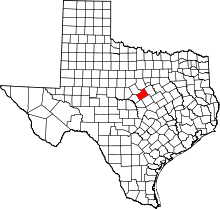 | |
| Town | ||
| Unincorporated communities | ||
| Ghost town | ||
| Footnotes | ‡This populated place also has portions in an adjacent county or counties | |