Indiana State Road 128
| ||||
|---|---|---|---|---|
 | ||||
| Route information | ||||
| Maintained by INDOT | ||||
| Length: | 10.865 mi[1] (17.486 km) | |||
| Major junctions | ||||
| West end: |
| |||
| East end: |
| |||
| Location | ||||
| Counties: | Madison | |||
| Highway system | ||||
| ||||

State Road 128 (SR 128) is a part of the Indiana State Road that runs through Madison County in the US state of Indiana. The 10.87 miles (17.49 km) of SR 128 that lie within Indiana serve as a minor highway. None of the highway is listed on the National Highway System. Most of the route is a rural two-lane highway. The highway passes through residential properties and farmland.
Route description
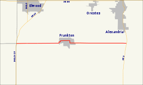
SR 128 begins at the concurrency of State Road 13 and State Road 37 on the western border of Madison County. The route heads east as a two-lane rural highway passing through farmland, with some houses. The road enters Frankton and makes a series of sharp curves. The road passes through residential properties, through Frankton. On the east side of Frankton, the highway makes a series of sharp curves leaving Frankton. East of Frankton the road heads east, passes through farmland with some houses. The eastern terminus of SR 128 is at SR 9 in rural Madison County. East of SR 9, the road continues as a county road through the remainder of Madison County. The county road becomes State Road 332 at an interchange with Interstate 69 just inside Delaware County.[2][3]
No segment of State Road 128 in Indiana that is included in the National Highway System (NHS).[4] The NHS is a network of highways that are identified as being most important for the economy, mobility and defense of the nation.[5] The highway is maintained by the Indiana Department of Transportation (INDOT) like all other state roads in the state. The department tracks the traffic volumes along all state roads as a part of its maintenance responsibilities using a metric called average annual daily traffic (AADT). This measurement is a calculation of the traffic level along a segment of roadway for any average day of the year. In 2010, INDOT figured that lowest traffic levels were 1,200 vehicles and 110 commercial vehicles used the highway daily west of Frankton. The peak traffic volumes were 3,490 vehicles and 150 commercial vehicles AADT along the section east of Frankton.[6]
Major intersections
The entire route is in Madison County.
| Location | mi[1] | km | Destinations | Notes | |
|---|---|---|---|---|---|
| Pipe Creek Township | 0.000 | 0.000 | Western terminus of SR 128 | ||
| Monroe Township | 10.865 | 17.486 | Eastern terminus of SR 128 | ||
| 1.000 mi = 1.609 km; 1.000 km = 0.621 mi | |||||
References
- 1 2 Indiana Department of Transportation (July 2015). Reference Post Book (PDF). Indianapolis: Indiana Department of Transportation. Retrieved September 17, 2016.
- ↑ Indiana Department of Transportation (2012). Indiana Transportation Map (PDF) (Map) (2011–12 ed.). 1:550,000. Indianapolis: Indiana Department of Transportation. OCLC 765461296. Retrieved November 30, 2012.
- ↑ Google (November 30, 2012). "Overview of State Road 128" (Map). Google Maps. Google. Retrieved November 30, 2012.
- ↑ Federal Highway Administration (December 2003). National Highway System: Indiana (PDF) (Map). Scale not given. Washington, DC: Federal Highway Administration. Retrieved November 30, 2012.
- ↑ Natzke, Stefan; Neathery, Mike; Adderly, Kevin (September 26, 2012). "What is the National Highway System?". National Highway System. Federal Highway Administration. Retrieved November 30, 2012.
- ↑ Indiana Department of Transportation (2010). "Indiana Traffic Counts". Indianapolis: Indiana Department of Transportation. Retrieved November 30, 2012.