Pipe Creek Township, Madison County, Indiana
| Pipe Creek Township | |
|---|---|
| Township | |
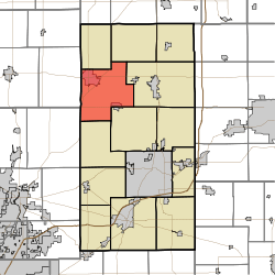 Location in Madison County | |
| Coordinates: 40°14′40″N 85°48′02″W / 40.24444°N 85.80056°WCoordinates: 40°14′40″N 85°48′02″W / 40.24444°N 85.80056°W | |
| Country |
|
| State |
|
| County | Madison |
| Government | |
| • Type | Indiana township |
| Area | |
| • Total | 42.47 sq mi (110.0 km2) |
| • Land | 42.41 sq mi (109.8 km2) |
| • Water | 0.06 sq mi (0.2 km2) 0.14% |
| Elevation | 860 ft (262 m) |
| Population (2010) | |
| • Total | 12,497 |
| • Density | 294.6/sq mi (113.7/km2) |
| ZIP codes | 46001, 46036, 46044 |
| GNIS feature ID | 0453741 |
Pipe Creek Township is one of fourteen townships in Madison County, Indiana, United States. As of the 2010 census, its population was 12,497 and it contained 5,828 housing units.[1]
History
Pipe Creek Township was organized in 1833, and named after Pipe Creek.[2]
Geography
According to the 2010 census, the township has a total area of 42.47 square miles (110.0 km2), of which 42.41 square miles (109.8 km2) (or 99.86%) is land and 0.06 square miles (0.16 km2) (or 0.14%) is water.[1]
Cities, towns, villages
- Elwood (vast majority)
- Frankton (north side)
- West Elwood
Unincorporated towns
- Dundee at 40°16′20″N 85°45′22″W / 40.272262°N 85.756089°W
- South Elwood at 40°15′45″N 85°50′32″W / 40.262539°N 85.842202°W
Cemeteries
The township contains these nine cemeteries: Carr, Elwood, Howard, Prewett, Saint Josephs, Shell, Sigler, Stoken and Sunset Memorial Park.
Major highways
Airports and landing strips
- Elwood Airport
School districts
- Elwood Community School Corporation
- Frankton-Lapel Community Schools
Political districts
- Indiana's 6th congressional district
- State House District 36
- State Senate District 20
- State Senate District 25
References
- "Pipe Creek Township, Madison County, Indiana". Geographic Names Information System. United States Geological Survey. Retrieved 2009-10-08.
- United States Census Bureau 2008 TIGER/Line Shapefiles
- IndianaMap
- 1 2 "Population, Housing Units, Area, and Density: 2010 - County -- County Subdivision and Place -- 2010 Census Summary File 1". United States Census. Retrieved 2013-05-10.
- ↑ Forkner, John La Rue & Dyson, Byron H. (1897). Historical Sketches and Reminiscences of Madison County, Indiana. Wilson, Humprheys & Co. p. 872.
External links
- Indiana Township Association
- United Township Association of Indiana
- City-Data.com page for Pipe Creek Township
 |
Duck Creek Township | Boone Township | | |
| Madison Township, Tipton County | |
Monroe Township | ||
| ||||
| | ||||
| White River Township, Hamilton County | Jackson Township | Lafayette Township |
Municipalities and communities of Madison County, Indiana, United States | ||
|---|---|---|
| Cities | ||
| Towns | ||
| Townships | ||
| Unincorporated communities |
| |
| Footnotes | ‡This populated place also has portions in an adjacent county or counties | |
This article is issued from Wikipedia - version of the 10/25/2016. The text is available under the Creative Commons Attribution/Share Alike but additional terms may apply for the media files.