Ingol
Coordinates: 53°47′12″N 2°44′46″W / 53.7866°N 2.746°W
| Ingol | |
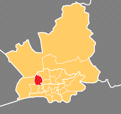 Shown within the City of Preston |
|
| Population | 7,369 (2011) |
|---|---|
| District | City of Preston |
| Ceremonial county | Lancashire |
| Region | |
| Country | England |
| Sovereign state | United Kingdom |
| EU Parliament | North West |
| UK Parliament | Preston |
| Councillors |
|
Ingol is an electoral ward and suburb of Preston, Lancashire, England. The population of the Ward as taken at the 2011 census was 7,369.[1] The ward also includes the suburb of Tanterton. The ward is coterminous with the civil parish of Ingol and Tanterton, created in 2012.
With a golf course within its boundaries and continued new housing development, the area is suburban in its northern and central areas with a more significant low income housing area in its eastern part. Ingol and Tanterton straddle the historic boundary between the former County Borough of Preston and Fulwood Urban District.
Ingol has running through it the main Woodplumpton Road running from Preston’s Lane Ends shopping community to the villages in the parish of Woodplumpton and the borough of Wyre. The city-wide orbital service provided by Preston Bus cuts through both suburban and new-build areas of the Ingol area.
Three members of Preston City Council, elected 'in thirds' in first past the post elections each year, are returned from the ward. The ward forms part of the Lancashire County Council electoral division of Preston West.
Current members
| Election | Member | Party | |
|---|---|---|---|
| Preston City Council election, 2014 | Neil Darby | Liberal Democrat | |
| Preston City Council election, 2015 | Jason Jeffrey | Liberal Democrat | |
| Preston City Council election, 2016 | Pauline Brown | Liberal Democrat | |
Demographics
From the 2001 census,[2] the area had a population of 7,395. Of this figure, 79% described themselves as Christian. At the 2008 local elections, the valid electorate for Ingol ward was 5,642.
Geography
The ward is in the west of the city with the M55 motorway at its northern edge, largely following Woodplumpton Road from Tulketh to the boundary of Woodplumpton parish, then continuing through terraced and detached housing in an easterly direction. A number of Preston Bus services use the local roads through the area.
Ingol and Tanterton neighbourhood
Civil parishes in the City of Preston | ||
|---|---|---|
| Ba | ||
| Br | ||
| Go | ||
| Gr | ||
| H | ||
| I | ||
| L | ||
| Wh | ||
| Wo | ||

In April 2012, the civil parish of Ingol and Tanterton was created, styled as a "neighbourhood" with a neighbourhood council.[3] The neighbourhood has the same boundaries as Ingol ward, and was previously part of the unparished area of Preston.
See also
Sources
- ↑ "Preston ward population 2011". Retrieved 18 January 2016.
- ↑ for National Statistics
- ↑ The Preston City Council (Reorganisation of Community Governance) Order 2011, 19 December 2011, accessed 26 November 2015
Geography of the City of Preston district | |||||||||||
|---|---|---|---|---|---|---|---|---|---|---|---|
| Cities |  | ||||||||||
| Suburbs | |||||||||||
| Villages | |||||||||||
| Parishes | |||||||||||
| Topography |
| ||||||||||