Maudland Bridge railway station
| Maudland Bridge | |
|---|---|
|
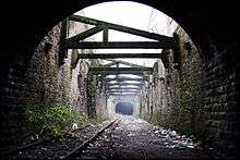
Site of former station in 2007. The bridge in the foreground was over the Lancaster Canal | |
| Location | |
| Place | Maudland Road, Preston |
| Area | Preston |
| Coordinates | 53°45′45″N 2°42′37″W / 53.7626°N 2.7103°WCoordinates: 53°45′45″N 2°42′37″W / 53.7626°N 2.7103°W |
| Operations | |
| Original company | Fleetwood, Preston and West Riding Junction Railway |
| Pre-grouping | Lancashire and Yorkshire Railway/London and North Western Railway |
| Platforms | 1 |
| History | |
| 1 November 1856 | Opened[1] |
| 1 June 1885 | Closed[1] |
| Disused railway stations in the United Kingdom | |
|
Closed railway stations in Britain A B C D–F G H–J K–L M–O P–R S T–V W–Z | |
|
| |

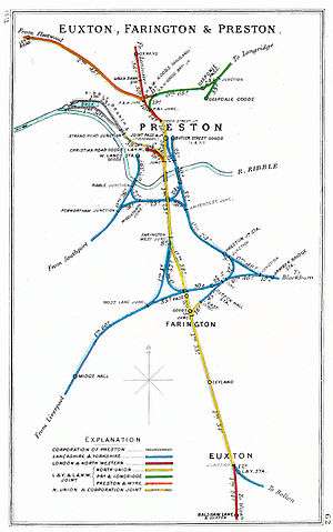
Maudland Bridge railway station was once the Preston terminus of the Longridge Branch Line, in Lancashire, England. It was located on Maudland Road, between a bridge over the Lancaster Canal and Cold Bath Street. The Maudlands district of Preston gets its name from the medieval St. Mary Magdalen's leper hospital, which once stood near the present-day St Walburge's Church.[2]
History
In 1850, the Fleetwood, Preston and West Riding Junction Railway (FP&WRR) built the 862-yard (788 m) Miley Tunnel to connect two existing lines, the Preston and Longridge Railway at Deepdale, and the Preston and Wyre Joint Railway (P&WR) at Maudland. The plan was to link Fleetwood on the Fylde coast to Skipton in the West Riding of Yorkshire. However the plan collapsed in 1852, and so the tunnel was initially used for goods traffic only.[3]
In 1856, the FP&WRR revived and diverted passenger trains via the tunnel to a new Maudland Bridge station. By 1867 the line was owned jointly by the Lancashire and Yorkshire Railway and the London and North Western Railway (LNWR). In 1885, the track layout at Maudland was altered to allow Longridge trains to run on the adjacent LNWR West Coast Main Line to Preston railway station, and Maudland Bridge was closed. A goods station, to replace the demolished P&WR Maudland station, was built nearby.[4]
Although the line through Maudland Bridge station closed to passengers in 1930, it continued to be used for goods until the 1990s. The tracks, now rusty and overgrown, still exist. The site of the former goods station is now occupied by the University of Central Lancashire's Roeburn Hall student residence.[5][6]
Accidents
The disused Miley Tunnel has been the site of several accidents in recent years. Two young men were injured in separate incidents in 1998 and 2000, each falling over 30 feet (10 m) into the tunnel off a wall near Moor Lane. On Christmas Day 2002, a drunken youth fell to his death at the same point. Network Rail erected 10-foot (3 m) fences six weeks later.
In October 2003 another drunken man fell onto the disused line at Maudland Bank but escaped serious injury.[7]
The future
In 2003, the Preston City Link Canal Trust was formed with a plan to reopen part of the Lancaster Canal to a new marina to be constructed in the vicinity of the former Maudland Bridge station. One option being considered is to reopen the Longridge line as far as Deepdale or Ribbleton, the line passing by viaduct over the new marina.[8][9]
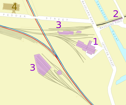 Railways in the Maudlands area in 1849 |
 1892 |
 2012 | |
| |
Notes
- 1 2 Butt, R. V. J. (1995). The Directory of Railway Stations: details every public and private passenger station, halt, platform and stopping place, past and present (1st ed.). Sparkford: Patrick Stephens Ltd. p. 191. ISBN 1-8526-0508-1. OCLC 60251199.
- ↑ Hunt, p.81
- ↑ Hunt, p.117; Till, pp.91–92; Suggitt p.50
- ↑ Hunt, p.117; Till, p.101; Suggitt pp.50–51
- ↑ Suggitt pp.52–53
- ↑ "Map of UCLAN Preston City Campus" (PDF). (902 KiB), accessed 5 July 2007
- ↑ "Man falls 20ft near railway death site", Lancashire Evening Post 4 October 2003, accessed online 5 July 2007
- ↑ Broom, E. "Answer to Preston’s transport problems?", Lancashire Evening Post 12 February 2007, accessed online 18 June 2007
- ↑ "Preston City Link Canal Trust" accessed 13 June 2007
References
- Hunt, D. (2003) The Wharncliffe Companion to Preston — An A to Z of Local History, Wharncliffe Books, Barnsley, ISBN 1-903425-79-4.
- Suggitt, G. (2003, revised 2004) Lost Railways of Lancashire, Countryside Books, Newbury, ISBN 1-85306-801-2
- Till, J.M. (1993) A History of Longridge and its People, Carnegie Publishing, Preston, ISBN 0-948789-92-1
| Maps showing Maudland Bridge Station |
| OS 1:2500 Map on MARIO (about 1893) |
| OS 1:10000 Map on MARIO (about 1847) |
| Other maps |
| Preceding station | Disused railways | Following station | ||
|---|---|---|---|---|
| Terminus | LYR/LNWR joint Fleetwood, Preston and West Riding Junction Railway |
Deepdale towards Longridge | ||