River Ribble
| River Ribble | |
|---|---|
|
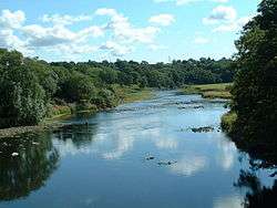
The River Ribble at Ribchester | |
| Country | England |
| Basin | |
| Main source |
Confluence of Gayle Beck and Cam Beck, Selside, Ribblehead 807 ft (246 m) |
| River mouth | Irish Sea at Lytham |
| Physical characteristics | |
| Length | 75 mi (121 km) |
The River Ribble is a river that runs through North Yorkshire and Lancashire in Northern England.
History
Neolithic to Saxon finds from along the River Ribble during the creation of the Preston Docks and other revealed man has been in the area for a long time. The River Ribble looked completely different then and the coastline is likely to have been much further inland than it is at present where land has been reclaimed and the marsh extended out into the River Ribble due to sedimentation.
The Ribble would appear to have been known in Roman times as the Belisama,[1] possibly giving its name to Samlesbury. Ptolemy's "Belisama aest." seems to represent the estuary of the Ribble. Bremetennacum was a Roman fort that guarded a crossing-point of the river at Ribchester. Remains of another Roman site were discovered at Walton-le-Dale in the mid 19th century.
The medieval silver Mitton Hoard was found near where this river joins the River Hodder in 2009.[2] Whilst the Cuerdale Hoard, the largest Viking silver hoard ever found outside Russia was discovered in 1840 on the southern bank of a bend of the river, at Cuerdale near Preston.
At one time the Ribble marked the northernmost extent of the ancient kingdom of Mercia.[3] At the time of the Domesday Book, the river formed the northern boundary of an area of land (known as Inter Ripam et Mersam) that was included in the Domesday information for Cheshire,[4] though it was probably not formally part of the county of Cheshire.[5][6][7]
Geography
The Ribble begins at the confluence of the Gayle Beck and Cam Beck near the famous viaduct at Ribblehead, in the shadow of the Yorkshire three peaks. It is the only major river rising in Yorkshire which flows westward. It flows through Settle, Clitheroe, Ribchester and Preston, before emptying into the Irish Sea between Lytham St. Annes and Southport, a length of 75 miles (121 km). Its main tributaries are the Hodder and Calder which join the river near Great Mitton, the River Darwen which joins at Walton-le-Dale and the River Douglas which joins near Hesketh Bank.
Above Hellifield the valley of the river is known as Ribblesdale.
The Ribble Way is a long-distance footpath which follows the river for much of its course. The river is connected to both the Leeds and Liverpool Canal and the Lancaster Canal (via the Ribble Link). The river downstream of Preston was actively dredged when Preston was an active port; this is no longer done and silt from the river is now spreading more widely over the (sand) beaches around Fairhaven and St. Annes.
Its 10-mile-wide (16 km) estuary forms part of the Ribble and Alt Estuaries Special Protection Area for wildlife. An average of 340,000 water birds over-winter in the estuary making it the most important wetland site in Britain. The Ribble is also a key breeding ground for the endangered Atlantic salmon.[3]
1.25 million people live in the Ribble's catchment area.[3]
The Normal Tidal Limit (NTL) of the river is at Fishwick Bottoms, between Preston and Walton-le-Dale, 11 miles (18 km) from the sea.[3]
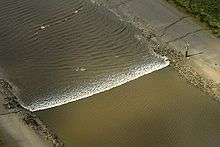
The River Ribble has the third largest tides in England, with tides that run at 4 knots (5 mph; 7 km/h) and a tidal range at the mouth of the river of 26 feet (8 m) during spring tides. Since River Ribble dredging ceased, the estuary is filling up with sand and is developing a meandering path, depending on the tides and river runoff. In addition, many tributaries flow into the main channel including the Savick Brook/Ribble Link, while the River Douglas, has a significant influence both on sediment transport and hydrodynamics of the estuary.[8]
Ribble campaigns
The River Ribble catchment is covered by the Mersey Basin Campaign, a partnership which was established in 1985 to improve water quality and encourage waterside regeneration.
Preston City Council have published plans to build a barrage across the River Ribble, in their 'Riverworks' proposals. The aim of these proposals is to build a water sports park on a section of the Ribble, coupled with over 4,000 units of high quality housing and businesses in the river's flood plain. Some local residents are opposing these plans, arguing that they endanger wildlife, increase flood risk to local housing and damage greenbelt areas. These residents have set up the 'Save The Ribble' campaign. Parts of the river are a County Biological Heritage Site.
People living near the Ribble Estuary have set up the 'Ribble Estuary Against Fracking' campaign to protest about plans to carry out fracking for shale gas in the area.[9]
Settlements

North Yorkshire
Lancashire
- Paythorne
- Sawley
- West Bradford
- Horrocksford
- Clitheroe
- Great Mitton
- Little Town
- Ribchester
- Samlesbury
- Walton-le-Dale
- Preston
- Penwortham
- Tarleton
- Hundred End
- Banks
- Lytham
Main tributaries
- River Douglas or River Asland
- Savick Brook
- River Darwen
- Stydd Brook
- Dinckley Brook
- River Calder
- River Hodder
Name
The River Ribble gives its name to the local government boroughs of Ribble Valley and South Ribble, and the Ribble Valley parliamentary constituency. The Ribble Bus Company once operated throughout North West England. The Ribble also lends its name to the Ribble Steam Railway, Ribble Cycles, a bicycle manufacturer based in Preston, and Ribble Valley Inns.
References
Notes
- ↑ Hutton, p. 218
- ↑ Coin hoard BM-193206, Finds.org.uk, Retrieved 16 September 2015
- 1 2 3 4 "River Ribble Factsheet (pdf file)" (PDF). Mersey Basin Campaign Official Website. Retrieved 15 August 2015.
- ↑ Morgan (1978); pp. 269c–301c,d.
- ↑ Harris and Thacker (1987). write on page 252:
Certainly there were links between Cheshire and south Lancashire before 1000, when Wulfric Spot held lands in both territories. Wulfric's estates remained grouped together after his death, when they were left to his brother Aelfhelm, and indeed there still seems to have been some kind of connexion in 1086, when south Lancashire was surveyed together with Cheshire by the Domesday commissioners. Nevertheless, the two territories do seem to have been distinguished from one another in some way and it is not certain that the shire-moot and the reeves referred to in the south Lancashire section of Domesday were the Cheshire ones.
- ↑ Phillips and Phillips (2002). pp. 26–31.
- ↑ Crosby, A. (1996). writes on page 31:
The Domesday Survey (1086) included south Lancashire with Cheshire for convenience, but the Mersey, the name of which means 'boundary river' is known to have divided the kingdoms of Northumbria and Mercia and there is no doubt that this was the real boundary.
- ↑ http://web.archive.org/web/20071018024442/http://www.srp-uk.org/srpcdrom/p8-4.doc
- ↑ http://www.reaf.org.uk/news.php
Bibliography
- Crosby, A. (1996). A History of Cheshire. (The Darwen County History Series.) Chichester, West Sussex, UK: Phillimore & Co. Ltd. ISBN 0-85033-932-4.
- Harris, B. E., and Thacker, A. T. (1987). The Victoria History of the County of Chester. (Volume 1: Physique, Prehistory, Roman, Anglo-Saxon, and Domesday). Oxford: Oxford University Press. ISBN 0-19-722761-9.
- Hutton, R. (1991) The Pagan Religions of the Ancient British Isles, Oxford : Blackwell, ISBN 0-631-17288-2
- Morgan, P. (1978). Domesday Book Cheshire: Including Lancashire, Cumbria, and North Wales. Chichester, Sussex: Phillimore & Co. Ltd. ISBN 0-85033-140-4.
- Phillips A. D. M., and Phillips, C. B. (2002), A New Historical Atlas of Cheshire. Chester, UK: Cheshire County Council and Cheshire Community Council Publications Trust. ISBN 0-904532-46-1.
- Greenhalgh, M (2009). Ribble: river and valley, a local and natural history. Lancaster, Carnegie Publishing. ISBN 978-1-85936-135-1.
Further reading
- D. J. Assinder; S. M. Mudge & G. S. Bourne (1997). "Radiological assessment of the Ribble estuary—I. Distribution of radionuclides in surface sediments". Journal of Environmental Radioactivity. Published by Elsevier Science Ltd. 36 (1): 1–19. doi:10.1016/S0265-931X(96)00073-2.
- S. M. Mudge; G. S. Bourne & D. J. Assinder (1997). "Radiological assessment of the Ribble estuary—II. Beta and gamma dose rates and doses to critical groups". Journal of Environmental Radioactivity. Published by Elsevier Science Ltd. 36 (1): 21–41. doi:10.1016/S0265-931X(96)00074-4.
- S. M. Mudge; D. J. Assinder & G. S. Bourne (1997). "Radiological assessment of the Ribble estuary—III. Redistribution of radionuclides". Journal of Environmental Radioactivity. Published by Elsevier Science Ltd. 36 (1): 43–67. doi:10.1016/S0265-931X(96)00075-6.
External links
| Wikimedia Commons has media related to River Ribble. |
Coordinates: 53°45′N 2°46′W / 53.750°N 2.767°W
| Rivers | |
|---|---|
| Canals | |
| Others | |