Insworke
| Insworke | |
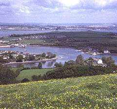 View north from Maker Heights: below is Millbrook Lake with Foss Point splitting its headwaters to the left and Insworke village on the opposite side; St John's Lake, Torpoint and the Tamar Road Bridge are beyond |
|
 Insworke |
|
| OS grid reference | SX427526 |
|---|---|
| Unitary authority | Cornwall |
| Ceremonial county | Cornwall |
| Region | South West |
| Country | England |
| Sovereign state | United Kingdom |
| EU Parliament | South West England |
Coordinates: 50°21′11″N 4°12′43″W / 50.353°N 4.212°W
Insworke (formerly also Inceworth) is a hamlet in the parish of Millbrook (before 1869 in the parish of Maker)[1] in southeast Cornwall, England, UK.[2][3] A fair and annual market were held here from 1319.[4]
References
External links
![]() Media related to Insworke at Wikimedia Commons
Media related to Insworke at Wikimedia Commons
Cornwall Portal | |
| Unitary authorities | |
| Major settlements |
|
| Rivers | |
| Topics | |
This article is issued from Wikipedia - version of the 10/20/2016. The text is available under the Creative Commons Attribution/Share Alike but additional terms may apply for the media files.