Interstate 696
| ||||
|---|---|---|---|---|
| Walter P. Reuther Freeway | ||||
|
I-696 highlighted in red | ||||
| Route information | ||||
| Auxiliary route of I-96 | ||||
| Maintained by MDOT | ||||
| Length: | 28.368 mi[1] (45.654 km) | |||
| History: | Construction started in 1961 and completed December 15, 1989[2] | |||
| Restrictions: | No flammable or explosive cargo between M-10 and I-75[3] | |||
| Major junctions | ||||
| West end: |
| |||
|
| ||||
| East end: |
| |||
| Location | ||||
| Counties: | Oakland, Macomb | |||
| Highway system | ||||
| ||||

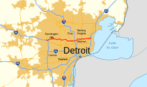
Interstate 696 (I-696) is an east–west auxiliary Interstate Highway in the US state of Michigan. The state trunkline highway is also known as the Walter P. Reuther Freeway, named for the prominent auto industry union head by the Michigan Legislature in 1971. I-696 is a bypass route, detouring around the city of Detroit through the city's northern suburbs in Oakland and Macomb counties. It starts by branching off I-96 and I-275 at its western terminus in Novi, and runs through suburbs including Southfield, Royal Oak and Warren before merging into I-94 at St. Clair Shores on the east end. It has eight lanes for most of its length and is approximately 10 miles (16 km) north of downtown Detroit. I-696 connects to other freeways such as I-75 (Chrysler Freeway) and M-10 (Lodge Freeway). Local residents sometimes refer to I-696 as "The Autobahn of Detroit."
Planning for the freeway started in the 1950s. Michigan state officials proposed the designation I-98, but this was not approved. Construction started on the first segment in 1961, and the Lodge Freeway was designated Business Spur Interstate 696 (BS I-696) the following year. The western third of the freeway opened in 1963, and the eastern third was completed in January 1979. The central segment was the subject of much controversy during the 1960s and 1970s. Various municipalities along this stretch argued over the routing of the freeway such that the governor locked several officials into a room overnight until they would agree to a routing. Later, various groups used federal environmental regulations to force changes to the freeway. The Orthodox Jewish community in Oak Park was concerned about pedestrian access across the freeway; I-696 was built with a set of parks on overpasses to accommodate their needs. The Detroit Zoo and the City of Detroit also fought components of the freeway design. These concessions delayed the completion of I-696 until December 15, 1989. Since completion, the speed limit was raised from 55 to 70 miles per hour (90 to 115 km/h). In addition, some interchanges were reconfigured in 2006.
Route description
.png)
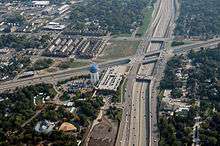
I-696, which has been called "Detroit's Autobahn" by some residents[4] reflecting a reputation for fast drivers,[5] begins in the west in the city of Novi as a left exit branching off I-96. This ramp is a portion of the I-96/I-696/I-275/M-5 interchange that spans the north–south, Novi–Farmington Hills city line linking together five converging freeways. The freeway curves southeasterly and then northeasterly through the complex as it runs eastward through the adjacent residential subdivisions. I-696 passes south of 12 Mile Road in the Mile Road System through Farmington Hills, passing south of Harrison High School and north of Mercy High School. After crossing into Southfield, I-696 passes through the Mixing Bowl,[6] another complex interchange that spans over two miles (3.2 km) near the American Center involving M-10 (the Lodge Freeway and Northwestern Highway) and US 24 (Telegraph Road) between two partial interchanges with Franklin Road on the west and Lahser Road on the east. The carriageways for I-696 run in the median of M-10 from northwest to southeast.[7][8] East of this interchange, cargo restrictions have been enacted for the next 10-mile-long (16 km) segment of I-696; no commercial vehicles may carry flammable or explosive loads.[3]

After passing through the Mixing Bowl, I-696 follows 11 Mile Road, which forms a pair of service drives for the main freeway. The Interstate passes through the city of Lathrup Village before turning southward and then easterly on an S-shaped path to run along 10 Mile Road.[7][8] This segment of freeway is known for its extensive use of retaining walls, with three large landscaped plazas forming short tunnels for freeway traffic near the Greenfield Road exit.[9] The freeway passes next to the Jewish Community Center of Metropolitan Detroit as it passes under the third pedestrian plaza. The Interstate then picks up 10 Mile Road, which forms a pair of service drives, as the Reuther runs along the border between the cities of Oak Park and Huntington Woods. I-696 follows the southern edge of the Detroit Zoo. Immediately east of the zoo, the Interstate intersects M-1 (Woodward Avenue),[7][8] and crosses a line of the Canadian National Railway that also carries Amtrak passenger service between Detroit and Pontiac.[10]
East of the rail crossing, I-696 has a four-level stack interchange with I-75 over the quadripoint for Royal Oak, Madison Heights, Hazel Park and Ferndale.[7][8] This interchange marks the eastern end of the cargo restrictions.[3] I-696 jogs to the northeast near the Hazel Park Raceway, leaving 10 Mile Road. Crossing into Warren in Macomb County at the Dequindre Road interchange, the freeway begins to follow 11 Mile Road again. Near the Detroit Arsenal Tank Plant, I-696 has another stack interchange for Mound Road; through the junction, the freeway makes a slight bend to the south. The freeway continues east through the northern edge of Center Line,[7][8] crossing a line of Conrail Shared Assets[10] and heading back into Warren. The Interstate crosses into Roseville near the M-97 (Groesbeck Highway) interchange and then meets M-3 (Gratiot Avenue) just west of the eastern terminus at I-94 (the Edsel Ford Freeway) in St. Clair Shores. The service drives merge in this final interchange and 11 Mile Road continues due east to Lake St.Clair.[7][8]
Like other state highways in Michigan, I-696 is maintained by the Michigan Department of Transportation (MDOT). In 2011, the department's traffic surveys showed that on average, 185,700 vehicles used the freeway daily east of I-75 and 38,100 vehicles did so each day in part of the Mixing Bowl, the highest and lowest counts along the highway, respectively.[11] As an Interstate Highway, all of I-696 is listed on the National Highway System,[12] a network of roads important to the country's economy, defense, and mobility.[13]
History
Planning and initial construction
I-696 is part of the original Interstate Highway System as outlined in 1956–58.[14] As originally proposed by the Michigan State Highway Department, the freeway would have been numbered I-98.[15] Construction started in 1961.[16] The Lodge Freeway, the first segment of which opened in 1957,[17] was given the Business Spur I-696 designation in 1962.[18][19] The first segment of I-696 built was the western third of the completed freeway which opened in 1963–64 at a cost of $16.6 million (equivalent to $259 million in 2015[20]). This section ran from the I-96 in Novi east to the Lodge Freeway in Southfield.[2] The then-unfinished freeway was named for Walter P. Reuther, former leader of the United Auto Workers labor union after he and his wife died in a plane crash on May 9, 1970. The next year the Michigan Legislature approved the naming by passing Senate Concurrent Resolution 57.[21]
In the late 1970s, during the second phase of construction, lobbying efforts and lawsuits attempted to block construction of the central section. If successful, the efforts would have left the freeway with a gap in the middle between the first (western) and second (eastern) phases of construction.[16] During this time, MDOT assigned M-6 to the eastern section of the freeway under construction. Signs were erected along the service roads that followed 11 Mile Road to connect the already built stack interchange at I-75 east to I-94.[22] By the time the eastern freeway segment was initially opened in January 1979 between I-94 and I-75, the signage for M-6 was removed and replaced with I-696 signage;[23] it cost $200 million (equivalent to $954 million in 2015[20]) to complete.[2] Later in 1979, a closure was scheduled to allow work to be completed on three of the nine interchanges on the segment.[23]
Controversies over middle segment
The central section was the most controversial. Governor James Blanchard was 15 years old and a high school sophomore in neighboring Pleasant Ridge when the freeway was proposed[24] and purchased a home in the area in 1972.[16] He joked during remarks at the dedication in 1989, "The unvarnished truth about this freeway? I wasn't even alive when it was first proposed,"[24] and added, "frankly, I never thought it would go through."[16] Total cost at completion for the entire freeway at the end of the 30-year project was $675 million (equivalent to $1.65 billion in 2015[20]).[25]
Arguments between local officials were so intense that during the 1960s, then-Governor George W. Romney once locked fighting bureaucrats in a community center until they would agree on a path for the freeway. During the 1970s, local groups used then-new environmental regulations to oppose the Interstate.[16] The freeway was noted in a Congressional subcommittee report on the "Major Interstate System Route Controversy in Urban Areas" or the controversies in 1970. Before 1967, local communities had to approve highway locations and designs, and the debates over I-696 prompted the passage of an arbitration statute. That statute was challenged by Pleasant Ridge and Lathrup Village before being upheld by the Michigan Supreme Court.[26] Lathrup Village later withdrew from a planning agreement in 1971; had that agreement been implemented, construction on the central section was scheduled to commence in 1974 and finish in 1976.[27]
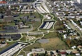
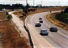
The community of Orthodox Jews in Oak Park wanted the freeway to pass to the north of their suburb. When this was deemed to be futile, the community asked for changes to the design that would mitigate the impact of the freeway to the pedestrian-dependent community. Final approval in 1981 of the freeway's alignment was contingent on these mitigation measures.[9] To address the community's unique needs, the state hired a rabbi to serve as a consultant on the project.[16] In addition, a series of landscaped plazas were incorporated into the design, forming the tunnels through which I-696 passes. These structures are a set of three 700-foot-wide (210 m) bridges that cross the freeway within a mile (1.6 km).[28] They allow members of the Jewish community to walk to synagogues on the Sabbath and other holidays[29] when Jewish law prohibits driving.[16] These plazas had their length limited; if they were longer they would be considered tunnels that would require ventilation systems.[30]
The Detroit Zoo was concerned that noise and air pollution from the Interstate would disturb the animals. They were satisfied by $12 million (equivalent to $29.3 million in 2015[20]) spent on a new parking ramp and other improvements.[24] The City of Detroit tried to stop I-696 as well, but in the end the city was forced to redesign its golf course. A refusal to grant an additional nine feet (2.7 m) of right-of-way by Detroit forced additional design and construction delays during the 1980s.[16]
One of the last obstacles to construction of the freeway was a wetlands area near Southfield. MDOT received a permit from the Michigan Department of Natural Resources to destroy 6 1⁄2 acres (2.6 ha) of wetland and create a replacement 11-acre (4.5 ha) area. In the process, some prairie roses and wetlands milkweed were transplanted from the path of I-696 in 1987.[31] The final section of the eight-lane freeway opened at a cost of $436 million[2] (equivalent to $1.06 billion in 2015[20]) on December 15, 1989. At the time, one caller to a Detroit radio show commented, "do you realize we have been to the moon and back in the time it has taken to get that road from Ferndale to Southfield?"[16]
Since completion
As part of the overall rehabilitation to the Mixing Bowl interchange, a new interchange at Franklin Road was to be constructed in 2006.[32] An exit ramp from I-696 eastbound to American Drive opened in April 2006. An entrance ramp from Franklin Road to I-696 westbound opened in July 2006. The Franklin Road overpass, which had been closed during this time, re-opened in October 2006.[33] On November 9 that year, the speed limit was increased from 55 to 70 mph (90 to 115 km/h) along the length of I-696.[5][34]
Exit list
| County | Location | mi[1] | km | Exit | Destinations | Notes |
|---|---|---|---|---|---|---|
| Oakland | Novi–Farmington Hills city line | 0.000– 1.371 | 0.000– 2.206 | 1 | Exits 163 and 165 on I-96 | |
| Farmington Hills | 4.570– 4.635 | 7.355– 7.459 | 5 | Orchard Lake Road | ||
| Southfield | 7.363– 7.489 | 11.850– 12.052 | 7 | American Drive | Eastbound exit and westbound entrance | |
| 7.763– 8.241 | 12.493– 13.263 | 8 | Eastbound exit and westbound entrance | |||
| 10.040 | 16.158 | 10 | Westbound exit and eastbound entrance to M-10; indirect eastbound exit and westbound entrance from Lahser Road via M-10 exit 16 | |||
| Southfield–Lathrup Village city line | 10.444– 11.300 | 16.808– 18.186 | 11 | Evergreen Road | ||
| Lathrup Village | 11.474– 12.359 | 18.466– 19.890 | 12 | 11 Mile Road, Southfield Road | ||
| Southfield–Oak Park city line | 13.008– 13.646 | 20.934– 21.961 | 13 | Greenfield Road | ||
| Oak Park–Huntington Woods city line | 13.982– 14.824 | 22.502– 23.857 | 14 | 10 Mile Road, Coolidge Road | ||
| Pleasant Ridge–Royal Oak city line | 15.743– 16.692 | 25.336– 26.863 | 16 | |||
| Royal Oak | 16.909 | 27.212 | 17 | Campbell Road, Hilton Road | Eastbound exit and westbound entrance; Campbell Road becomes Hilton Road immediately south of exit | |
| 17.373– 17.378 | 27.959– 27.967 | 17 | Bermuda Street | Westbound exit and eastbound entrance | ||
| Royal Oak–Madison Heights–Hazel Park–Ferndale city quadripoint | 17.706– 18.292 | 28.495– 29.438 | 18 | Exit 61 on I-75 | ||
| Madison Heights | 18.647– 18.668 | 30.009– 30.043 | 19 | Couzens Avenue, 10 Mile Road | Eastbound exit and westbound entrance | |
| Oakland–Macomb county line | Madison Heights–Warren city line | 19.258– 19.966 | 30.993– 32.132 | 20 | Dequindre Road, Ryan Road, John R Road | Dequindre Road is the county line; Ryan Road signed eastbound only, John R Road signed westbound only |
| Macomb | Warren | 20.523 | 33.029 | 21 | 11 Mile Road | Westbound exit and eastbound entrance |
| 21.512– 22.340 | 34.620– 35.953 | 22 | Mound Road | |||
| Center Line–Warren city line | 22.611– 23.160 | 36.389– 37.272 | 23 | Ryan Road signed westbound only | ||
| Warren | 23.666– 24.344 | 38.087– 39.178 | 24 | Hoover Road, Schoenherr Road | Schoenherr Road signed eastbound only | |
| 25.166– 26.259 | 40.501– 42.260 | 26 | Schoenherr Road signed westbound only | |||
| Roseville | 27.083– 27.771 | 43.586– 44.693 | 27 | |||
| 27.970– 27.991 | 45.013– 45.047 | 28 | 11 Mile Road | Eastbound exit and westbound entrance | ||
| St. Clair Shores | 28.271– 28.368 | 45.498– 45.654 | — | Exit 229 on I-94 | ||
| 1.000 mi = 1.609 km; 1.000 km = 0.621 mi | ||||||
Related trunkline
| |
|---|---|
| Location: | Detroit–Southfield |
| Length: | 17.538 mi[1] (28.225 km) |
| Existed: | 1962[18][19]–1970[35][36] |
Business Spur Interstate 696 (BS I-696) was the designation given to the Lodge Freeway in the Detroit area in 1962.[18][19] This 17 1⁄2-mile-long (28.2 km) freeway was renumbered as part of US 10 in 1970, when that highway designation was shifted off Woodward Avenue.[35][36]
See also
 Metro Detroit portal
 Michigan Highways portal
References
- 1 2 3 Michigan Department of Transportation & Michigan Center for Shared Solutions and Technology Partnerships (2009). MDOT Physical Reference Finder Application (Map). Michigan Department of Transportation. Retrieved July 13, 2012.
- 1 2 3 4 Brown, Warren (February 4, 1990). "Home of the American Auto Finds Reuther Freeway a Mixed Blessing". The Washington Post. p. H2. ISSN 0740-5421. OCLC 9965758. Retrieved July 13, 2012 – via ProQuest Archiver. (subscription required (help)).
- 1 2 3 National Center for Manufacturing Sciences (n.d.). "Truck Driver's Guidebook: Hazardous Materials". The Border Center's WasteWatcher. National Center for Manufacturing Sciences. Retrieved July 13, 2012.
- ↑ Edmonds.com Editors (November 1998). "Long-Term Test: 1998 Volkswagen New Beetle". Edmunds.com. Archived from the original on September 14, 2008. Retrieved July 13, 2012.
- 1 2 Helms, Matt (October 11, 2006). "Speed Limit Rises To Match Habits". Detroit Free Press. p. B3. ISSN 1055-2758. OCLC 10345127, 137343179. Retrieved July 13, 2012 – via ProQuest Archiver. (subscription required (help)).
- ↑ Michigan Infrastructure and Transportation Association (Summer 2007). "MITA Presents Michigan Construction Quality Partnership Awards" (PDF). Cross-Section. Michigan Infrastructure and Transportation Association. p. 11. Retrieved August 30, 2012.
- 1 2 3 4 5 6 Michigan Department of Transportation (2012). Pure Michigan: State Transportation Map (Map). c. 1:158,400. Lansing: Michigan Department of Transportation. Detroit Area inset. §§ C3–C13. OCLC 42778335, 794857350.
- 1 2 3 4 5 6 Google (July 13, 2012). "Overview Map of I-696" (Map). Google Maps. Google. Retrieved July 13, 2012.
- 1 2 Center for Urban Transportation Research (2000). "Community Cohesion: Oak Park, Michigan". Community Impact Assessment. University of South Florida. Archived from the original on May 25, 2006. Retrieved July 13, 2012.
- 1 2 Michigan Department of Transportation (January 2011). Michigan's Railroad System (PDF) (Map). Scale not given. Lansing: Michigan Department of Transportation. Retrieved February 1, 2011.
- ↑ Bureau of Transportation Planning (2008). "Traffic Monitoring Information System". Michigan Department of Transportation. Retrieved July 13, 2012.
- ↑ Michigan Department of Transportation (April 23, 2006). National Highway System, Michigan (PDF) (Map). Scale not given. Lansing: Michigan Department of Transportation. Retrieved October 7, 2008.
- ↑ Natzke, Stefan; Neathery, Mike & Adderly, Kevin (June 20, 2012). "What is the National Highway System?". National Highway System. Federal Highway Administration. Retrieved July 1, 2012.
- ↑ Bureau of Public Roads (September 1955). "Detroit and Environs" (Map). General Location of National System of Interstate Highways Including All Additional Routes at Urban Areas Designated in September 1955. Scale not given. Washington, DC: Government Printing Office. p. 41. OCLC 4165975. Retrieved July 13, 2012 – via Wikimedia Commons.
- ↑ Michigan State Highway Department (April 25, 1958). Recommended Interstate Route Numbering for Michigan (Report). Michigan State Highway Department. Archived from the original on August 5, 2004. Retrieved September 4, 2010.
- 1 2 3 4 5 6 7 8 9 Schmidt, William E. (December 15, 1989). "Pleasant Ridge Journal: The Freeway It Took A Generation to Build". The New York Times. ISSN 0362-4331. OCLC 1645522. Retrieved January 7, 2011.
- ↑ John C. Lodge Expressway Dedication Committee (1957). John C. Lodge Expressway Dedication Program. Detroit: John C. Lodge Expressway Dedication Committee. OCLC 34869718.
- 1 2 3 Michigan State Highway Department (1962). Official Highway Map (Map). Scale not given. Lansing: Michigan State Highway Department. Detroit inset. OCLC 12701120, 173191490.
- 1 2 3 Michigan State Highway Department (1963). Official Highway Map (Map). Scale not given. Lansing: Michigan State Highway Department. Detroit inset. OCLC 12701120.
- 1 2 3 4 5 United States nominal Gross Domestic Product per capita figures follow the Measuring Worth series supplied in Johnston, Louis & Williamson, Samuel H. (2016). "What Was the U.S. GDP Then?". MeasuringWorth. Retrieved April 10, 2016. These figures follow the figures as of 2015.
- ↑ Barnett, LeRoy (2004). A Drive Down Memory Lane: The Named State and Federal Highways of Michigan. Allegan Forest, MI: Priscilla Press. p. 234. ISBN 1-886167-24-9. OCLC 57425393.
- ↑ Auto Club of Michigan (September 1976). Detroit Northern Suburbs and Oakland County (Map) (Fall 1976–77 ed.). c. 1:44,352. Falls Church, VA: American Automobile Association. § P12. OCLC 49819797.
- 1 2 "I-94–I-75 Link To Open". Argus-Press. Owosso, MI. Associated Press. January 3, 1979. p. 16. OCLC 36134862. Retrieved January 7, 2011 – via Google News.
- 1 2 3 Hundley, Tom (December 15, 1989). "After 32 Years, Motor City Gets New Lifeline". Chicago Tribune. p. A6. ISSN 1085-6706. OCLC 7960243, 232606698. Retrieved July 13, 2012.
- ↑ Gavrilovich, Peter & McGraw, Bill (2000). The Detroit Almanac: 300 Years of Life in the Motor City. Detroit: Detroit Free Press. p. 235. ISBN 978-0-937247-34-1. OCLC 45227386.
- ↑ United States Senate Committee on Public Works Subcommittee on Roads (1970). Report on the Status of the Federal-Aid Highway Program Hearing, Ninety-First Congress, Second Session, April 15, 1970 (Report). Washington, DC: United States Government Printing Office. p. 93. OCLC 691111639. Retrieved August 21, 2012.
- ↑ "Lathrup Withdrawal May Delay 696 Development Plan". The Argus-Press. Owosso, MI. Associated Press. January 4, 1971. OCLC 36134862. Retrieved August 20, 2012.
- ↑ Stebbins, Win & Eustice, Mike (March 2006). "I-696: Three Pedestrian Plazas Over Freeway" (PDF). MDOT Context Sensitive Solutions Case Study: Metro Region. Michigan Department of Transportation. p. B1-17. Archived from the original on October 11, 2012. Retrieved October 10, 2012.
- ↑ Naber, MaryAnn (November 1, 2006). "Final List of Nationally and Exceptionally Significant Features of the Federal Interstate Highway System" (PDF). Historic Preservation: Interstate Highway System. Federal Highway Administration. p. 6. Retrieved July 22, 2012.
- ↑ Michalak, John (January 16, 1981). "Traveling into the Future on Imaginary Drive of I-696's Last Link". The Daily Tribune. Royal Oak, MI. ISSN 1041-9977. OCLC 15217591.
- ↑ "Michigan Freeway Link Won't Smell as Sweet". The Junction City Daily Union. Associated Press. October 14, 1987. p. 10. ISSN 0745-743X. OCLC 9420312. Retrieved August 15, 2013 – via Google News.
- ↑ Kalousdian, Aram (January 7, 2006). "Michigan Construction Will Increase". Michigan Contractor and Builder. Reed Business Information. Retrieved July 13, 2012. (subscription required)
- ↑ Oakland Transportation Service Center (March 22, 2006). "I-696/M-10 Reconstruction from Lahser Road to Beck Road (Project brochure)" (PDF). Michigan Department of Transportation. Archived from the original (PDF) on November 7, 2006. Retrieved May 30, 2006.
- ↑ Greenwood, Tom (June 19, 2006). "Metro Speed Limits on the Rise". The Detroit News. p. 2A. ISSN 1055-2715. OCLC 10345127, 137343179. Retrieved October 22, 2012 – via ProQuest Archiver. (subscription required (help)).
- 1 2 Michigan Department of State Highways (1970). Michigan, Great Lake State: Official Highway Map (Map). c. 1:158,400. Lansing: Michigan Department of State Highways. Detroit and Vicinity inset. OCLC 12701120.
- 1 2 Michigan Department of State Highways (1971). Michigan, Great Lake State: Official Highway Map (Map). c. 1:158,400. Lansing: Michigan Department of State Highways. Detroit and Vicinity inset. §§ A6–E9. OCLC 12701120, 77960415.
External links
| Wikimedia Commons has media related to Interstate 696. |
 Geographic data related to I-696 at OpenStreetMap
- I-696 at Michigan Highways
- I-696 at Michigan Highway Ends
- I-696 at Kurumi.com
- I-696 at AARoad's Interstate Guide
- I-696 at CanHighways
1Unsigned | ||