2003 Iowa highway jurisdictional transfer
|
Iowa's primary highway system | |
| System information | |
|---|---|
| Notes: | Primary highways in Iowa are generally state-maintained. |
| Highway names | |
| Interstates: | Interstate X (I-X) |
| US Highways: | U.S. Highway X (US X) |
| State: | Highway X (IA X or Iowa X) |
| System links | |
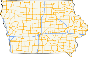
On July 1, 2003, the Iowa Department of Transportation transferred control of more than 700 miles (1,100 km) of highway to county and local governments in order to save money and to increase operational efficiency. Most of the highways turned over were short spurs connecting small, rural communities and state parks to the highway system.[1]
Route changes
Lengths represent the distances removed from the state highway system on or before July 1, 2003
| Number | Length (mi)[2] | Length (km) | Southern or western terminus | Northern or eastern terminus | Formed | Removed | Notes |
|---|---|---|---|---|---|---|---|
| 14.842 | 23.886 | I-80 near Dexter | US 169 in Adel | 1931 | current | Rerouted onto I‑80 and US 169 | |
| 4.655 | 7.491 | Route 15 south of Milton | Iowa 2 in Milton | 1969 | 2003 | ||
| 2.983 | 4.801 | Wall Lake | US 71 near Wall Lake | 1920 | 2003 | Spur route | |
| 3.524 | 5.671 | Allerton | Iowa 2 near Corydon | 1926 | 2003 | Spur route | |
| 1.827 | 2.940 | Malvern | US 34 near Malvern | 1920 | 2003 | Spur route | |
| 1.324 | 2.131 | Manilla | Iowa 141 near Manilla | — | 2003 | Spur route | |
| 27.228 | 43.819 | Iowa 2 in Bedford | US 34 in Adams County | — | 2003 | ||
| 7.135 | 11.483 | US 169 near Lehigh | Lehigh | — | 2003 | Spur route | |
| 4.506 | 7.252 | Seymour | Iowa 2 near Promise City | — | 2003 | Spur route | |
| 7.011 | 11.283 | Iowa 2 near Diagonal | Diagonal | — | 2003 | Spur route | |
| 1.933 | 3.111 | Melrose | US 34 near Melrose | — | 2003 | Spur route | |
| 2.685 | 4.321 | Iowa 92 near Keota | Keota | — | 2003 | Spur route | |
| 5.637 | 9.072 | Geode State Park | US 34 in Middletown | — | 2003 | Park access road | |
| 3.773 | 6.072 | Blairstown | US 30 near Blairstown | — | 2003 | Spur route | |
| 14.562 | 23.435 | Iowa 191 near Neola | US 59 in Avoca | — | — | ||
| 4.643 | 7.472 | Iowa 9 in Lyon County | MN 91 at the Minnesota state line | — | 2003 | ||
| 11.168 | 17.973 | US 151 Business in Cedar Rapids | Palo | — | 2003 | Spur route | |
| 1.532 | 2.466 | Russell | Russell | — | 2003 | Spur route | |
| 33.232 | 53.482 | US 34 in Burlington | US 61 in Wapello | — | 2003 | ||
| 15.401 | 24.786 | Iowa 163 near Pella | New Sharon city limits | 1980 | current | Short segment in New Sharon remains | |
| 15.649 | 25.185 | US 218 near Donnellson | US 61 / Iowa 2 in Fort Madison | — | 2003 | ||
| 27.579 | 44.384 | Iowa 3 near Alexander | CR B35 near Clear Lake | 1920 | 2011 | All but parts in Meservey and Thornton removed | |
| 1.268 | 2.041 | Oxford | US 6 near Oxford | — | 2003 | Spur route | |
| 1.187 | 1.910 | Iowa 64 near Spragueville | Spragueville | — | 2003 | Spur route | |
| 1.237 | 1.991 | US 34 near Stanton | Viking Lake State Park | — | 2003 | Park access road | |
| 2.567 | 4.131 | Iowa 4 in Calhoun County | Twin Lakes State Park | — | 2003 | Park access road | |
| 4.520 | 7.274 | Iowa 21 in Belle Plaine | US 30 near Belle Plaine | — | 2003 | Part of the Lincoln Highway | |
| 0.970 | 1.561 | US 30 in Nevada | Nevada | — | 2003 | Spur route | |
| 20.901 | 33.637 | Iowa 2 in Plano | Iowa 5 near Moravia | — | 2003 | ||
| 7.408 | 11.922 | I-29 near Thurman | US 275 near Sidney | — | 2003 | ||
| 6.706 | 10.792 | Rockford | Iowa 14 in Floyd County | — | 2003 | Spur route | |
| 4.748 | 7.641 | Iowa 5 near Marysville | Bussey | — | 2003 | Spur route | |
| 1.032 | 1.661 | US 63 near Lime Springs | Lime Springs | — | 2003 | Spur route | |
| 1.224 | 1.970 | Iowa 141 at Dedham | Iowa 141 near Dedham | — | 2003 | ||
| 9.596 | 15.443 | Iowa 5 / Iowa 92 near Pleasantville | Melcher-Dallas | — | 2003 | Spur route | |
| 31.143 | 50.120 | Council Bluffs city limits | Iowa 127 near Mondamin | — | — | Part of the Lincoln Highway | |
| 18.334 | 29.506 | Council Bluffs city limits | I-680 near Neola | — | — | ||
| 10.852 | 17.465 | US 18 in Fayette County | Iowa 24 in Jackson Junction | — | 2003 | ||
| 2.896 | 4.661 | Iowa 4 near Plover | Plover | — | 2003 | Spur route | |
| 2.567 | 4.131 | Iowa 3 near Albert City | Albert City | — | 2003 | Spur route | |
| 2.231 | 3.590 | Garrison | US 218 near Garrison | — | 2003 | Spur route | |
| 2.666 | 4.291 | Van Horne | US 218 near Van Horne | — | 2003 | Spur route | |
| 2.163 | 3.481 | US 30 near Keystone | Keystone | — | 2003 | Spur route | |
| 4.755 | 7.652 | Norway | US 30 / US 218 near Atkins | — | 2003 | Spur route | |
| 5.407 | 8.702 | Iowa 2 near Garden Grove | Garden Grove | — | 2003 | Spur route | |
| 2.927 | 4.711 | US 65 near Milo | Milo | — | 2003 | Spur route | |
| 6.221 | 10.012 | US 65 near Liberty Center | Liberty Center | — | 2003 | Spur route | |
| 3.058 | 4.921 | I-35 near New Virginia | New Virginia | — | 2003 | Spur route | |
| 5.736 | 9.231 | Iowa 175 near Ivester | Wellsburg | — | 2003 | Spur route | |
| 8.738 | 14.062 | Union | Iowa 175 in Eldora | — | 2003 | Spur route | |
| 3.909 | 6.291 | I-35 near Story City | Roland | — | 2003 | Spur route | |
| 7.688 | 12.373 | Sully | Iowa 146 in Searsboro | — | 2003 | Spur route | |
| 5.233 | 8.422 | Garwin | US 63 in Tama County | — | 2003 | Spur route | |
| 4.068 | 6.547 | US 34 west of New London | US 34 east of New London | — | 2003 | Former section of US 34 | |
| 1.063 | 1.711 | Iowa 9 near Harris | Harris | — | 2003 | Spur route | |
| 0.510 | 0.821 | Waubonsie State Park | Iowa 2 in Fremont County | — | 2003 | Park access road | |
| 6.389 | 10.282 | Royal | US 71 in Clay County | — | 2003 | Spur route | |
| 5.855 | 9.423 | US 34 in Mills County | Silver City | — | 2003 | Spur route | |
| 0.559 | 0.900 | Black Hawk Lake State Park | US 71 / Iowa 175 near Wall Lake, Iowa | — | 2003 | Park access road | |
| 0.771 | 1.241 | I-80 near Neola | Iowa 191 in Neola | — | 2003 | ||
| 0.665 | 1.070 | Iowa 78 near Winfield | Winfield | — | 2003 | Spur route | |
| 0.584 | 0.940 | US 61 / Iowa 92 near Grandview | Grandview | — | 2003 | Spur route | |
| 0.932 | 1.500 | Iowa 14 near Williamson | Williamson | — | 2003 | Spur route | |
| 1.989 | 3.201 | I-35 near Van Wert | US 69 near Van Wert | — | 2003 | ||
| 1.001 | 1.611 | US 169 near Tingley | Tingley | — | 2003 | Spur route | |
| 12.511 | 20.135 | Iowa 14 in Grundy County | US 20 near Cedar Falls | — | 2003 | Former section of US 20 | |
| 1.709 | 2.750 | US 69 near Weldon | Weldon | — | 2003 | Spur route | |
| 10.025 | 16.134 | Lake Wapello State Park | US 63 near Draksevill | — | 2003 | Park access road | |
| 15.506 | 24.954 | US 34 in Glenwood | I-29 in Council Bluffs | 1932 | current | Rerouted onto US 34 and I-29 | |
| 4.711 | 7.582 | Spirit Lake city limits | Minnesota state line | — | 2003 | Park access road | |
| 1.983 | 3.191 | US 30 / US 218 near Atkins | Atkins | — | 2003 | Spur route | |
| 5.283 | 8.502 | Quasqueton | Iowa 939 near Winthrop | — | 2003 | Spur route | |
| 0.796 | 1.281 | US 30 in Arcadia | Arcadia | — | 2003 | Spur route | |
| 9.932 | 15.984 | US 30 in Glidden | Lanesboro | — | 2003 | Spur route | |
| 1.833 | 2.950 | US 30 / US 218 near Newhall | Newhall | — | 2003 | Spur route | |
| 6.147 | 9.893 | Iowa 2 in Decatur County | Grand River | — | 2003 | Spur route | |
| 3.543 | 5.702 | Gilbertville | Raymond | — | 2003 | Double spur with I-380 | |
| 5.556 | 8.942 | New Providence | Iowa 175 near Eldora | — | 2003 | Spur route | |
| 1.411 | 2.271 | Modale | I-29 near Modale | — | 2003 | Spur route | |
| 2.045 | 3.291 | I-29 near Little Sioux | Little Sioux | — | 2003 | Spur route | |
| 2.554 | 4.110 | Letts | US 61 / Iowa 92 near Letts | — | 2003 | Spur route | |
| 0.783 | 1.260 | US 65 near Derby | Derby | — | 2003 | Spur route | |
| 6.277 | 10.102 | Ayrshire | US 18 near Ruthven | — | 2003 | Spur route | |
| 4.158 | 6.692 | Iowa 4 near Palmer | Palmer | — | 2003 | Spur route | |
| 2.660 | 4.281 | Pammel State Park | Iowa 92 in Madison County | — | 2003 | Park access road | |
| 0.510 | 0.821 | Iowa 175 near Onawa | Lewis and Clark State Park | — | 2003 | Park access road | |
| 3.617 | 5.821 | Spillville | US 52 near Calmar | — | 2003 | Spur route | |
| 2.070 | 3.331 | Iowa 276 in Spirit Lake | Near Orleans | — | 2003 | Spur route | |
| 12.939 | 20.823 | US 275 near Hamburg | US 59 near Shenandoah | — | — | ||
| 2.231 | 3.590 | Pikes Peak State Park | Iowa 76 in McGregor | — | 2003 | Park access road | |
| 1.032 | 1.661 | Lake Ahquabi State Park | US 65 / US 69 near Indianola | — | 2003 | Park access road | |
| 0.949 | 1.527 | Milford | West Okoboji | — | 2003 | Former section of US 71 | |
| 7.383 | 11.882 | Buckeye | Iowa 941 in Alden | — | 2003 | Spur route | |
| 5.469 | 8.802 | DeSoto National Wildlife Refuge | I-29 at Loveland | — | 2003 | Park access road | |
| 1.616 | 2.601 | Iowa 150 near Urbana | I-380 / Iowa 27 in Urbana | — | 2003 | ||
| 6.140 | 9.881 | Iowa 76 near Waukon Junction | Harpers Ferry | — | 2003 | Spur route | |
| 0.715 | 1.151 | Lake Keomah State Park | Iowa 92 near Keomah Village | — | 2003 | Park access road | |
| 4.792 | 7.712 | Lake MacBride State Park | Iowa 1 in Solon | — | 2003 | Park access road | |
| 1.311 | 2.110 | US 69 near Randall | Randall | — | 2003 | Spur route | |
| 1.231 | 1.981 | Iowa 25 in Guthrie County | Springbrook State Park | — | 2003 | Park access road | |
| 3.151 | 5.071 | Pacific Junction | US 34 / US 275 in Glenwood | — | 2003 | Spur route | |
| 2.685 | 4.321 | US 52 / Iowa 3 near Sageville | US 52 / Iowa 3 / Iowa 32 near Dubuque | — | 2003 | ||
| 2.113 | 3.401 | South of Plainfield | North of Plainfield | — | 2003 | Former section of US 218 | |
| 0.477 | 0.768 | SD 48 near Akron | Iowa 12 in Akron | — | 2003 | ||
| 0.249 | 0.401 | Lone Tree | Iowa 22 near Lone Tree | — | 2003 | Spur route | |
| 2.275 | 3.661 | US 34 near West Burlington | Burlington | — | 2003 | Spur route | |
| 2.157 | 3.471 | Backbone State Park | Iowa 3 / Iowa 13 near Strawberry Point | — | 2003 | Park access road | |
| 1.038 | 1.670 | Victor | US 6 / Iowa 21 near Victor | — | 2003 | Spur route | |
| 2.802 | 4.509 | South of Swedesburg | US 218 near Olds | — | 2003 | Former section of US 218 | |
| 6.140 | 9.881 | Maquoketa Caves State Park | US 61 near Maquoketa | — | 2003 | Park access road | |
| 0.755 | 1.215 | Iowa 24 in New Hampton | North of New Hampton | — | 2003 | Former section of US 63 | |
| 1.293 | 2.081 | Iowa 281 in Oelwein | Oelwein | — | 2003 | Former section of Iowa 150 | |
| 12.560 | 20.213 | Center Point | Iowa 150 near Urbana | — | 2003 | Former section of Iowa 150 | |
| 24.345 | 39.179 | I-80 / US 6 in Adair | US 6 near Dexter | — | 2003 | Former section of US 6 | |
| 19.017 | 30.605 | US 6 / Iowa 38 in Wilton | I-280 / US 6 near Davenport | — | 2003 | Former section of US 6 | |
| 20.168 | 32.457 | Iowa 17 near Webster City | CR D20 near Williams | — | 2003 | Former section of US 20 | |
| 0.789 | 1.270 | Murray city limits | Maple Street in Murray | — | 2003 | Former section of Iowa 152 | |
| 8.962 | 14.423 | I-35 in Ankeny | US 65 in Polk County | — | 2003 | ||
| 18.931 | 30.466 | Iowa 187 near Masonville | Black Hawk–Buchanan county line | — | 2003 | Former section of US 20 | |
| 12.953 | 20.846 | I-35 near Williams | Iowa Falls city limits | — | 2003 | Former section of US 20 | |
| 0.466 | 0.750 | Vine Street in Woodburn | Woodburn city limits | — | 2003 | Former section of Iowa 104 | |
| 4.599 | 7.401 | I-80 near Altoona | Iowa 931 in Polk County | — | 2003 | ||
| 2.275 | 3.661 | Glenwood city limits | US 34 / US 275 near Glenwood | — | 2003 | Former US 34 Business | |
| 0.112 | 0.180 | US 151 near Cascade | Reiter Road near Cascade | — | 2003 | Former section of US 151 | |
| 0.773 | 1.244 | US 61 near Maquoketa | Maquoketa city limits | — | 2003 | Former section of US 61 | |
| 0.727 | 1.170 | US 61 near Key West | Military Road in Key West | — | 2003 | Former section of US 61 | |
| 16.776 | 26.998 | CR F55 at Davenport | US 61 north of DeWitt | — | 2003 | Former section of US 61 | |
| 4.139 | 6.661 | US 151 near Key West | US 61 / US 151 in Dubuque | — | 2003 | Former section of US 151 and US 61 | |
| 13.366 | 21.510 | I-80 in Coralville | — | — | — | Short section south of I-80 remains | |
| 0.037 | 0.060 | US 20 near Farley | Farley city limits | — | 2003 | Former section of US 20 | |
| 2.007 | 3.230 | US 59 in Cherokee | Iowa 3 near Cherokee | — | 2003 | ||
| 2.772 | 4.461 | I-29 / US 34 near Glenwood | Iowa 385 near Pacific Junction | — | 2003 | Former section of US 34 | |
| 27.787 | 44.719 | Smithland city limits | Sioux City city limits | — | 2003 | Former section of Iowa 141 | |
| 1.927 | 3.101 | US 52 near Bellevue State Park | US 52 near Bellevue | — | 2003 | Park access road | |
| 2.312 | 3.721 | I-29 / I-680 near Crescent | Iowa 183 in Crescent | — | 2003 |
See also
 Iowa portal
 U.S. Roads portal
References
- ↑ "Evaluation of the State Highway System and Road Use Tax Fund" (PDF). April 1, 2003. Retrieved January 9, 2009.
- ↑ "2002 Volume of Traffic on the Primary Road System of Iowa" (PDF). Iowa Department of Transportation. January 1, 2002. Retrieved September 17, 2011.
This article is issued from Wikipedia - version of the 6/10/2015. The text is available under the Creative Commons Attribution/Share Alike but additional terms may apply for the media files.