Iron Gate Dam (California)
| Iron Gate Dam | |
|---|---|
| Country | United States |
| Location | Siskiyou County, California |
| Coordinates | 41°56′02″N 122°26′07″W / 41.93389°N 122.43528°WCoordinates: 41°56′02″N 122°26′07″W / 41.93389°N 122.43528°W |
| Opening date | 1964 |
| Dam and spillways | |
| Type of dam | Earthfill |
| Impounds | Klamath River |
| Height | 173 ft (53 m) |
| Length | 540 ft (160 m) |
| Spillway type | Concrete overflow |
| Reservoir | |
| Creates | Iron Gate Reservoir |
| Total capacity | 58,000 acre·ft (72,000,000 m3) |
| Catchment area | 4,630 sq mi (12,000 km2) |
| Surface area | 1,020 acres (410 ha) |
| Power station | |
| Turbines | 2 |
| Installed capacity | 18 MW |
| Annual generation | 112,650,000 KWh |
Iron Gate Dam is an earthfill hydroelectric dam on the Klamath River in northern California. It is the lowermost of a series of power dams on the river, the Klamath River Hydroelectric Project, operated by PacifiCorp. It also poses the first barrier to migrating salmon in the Klamath.
The Iron Gate Dam along with the John C. Boyle Dam are two of four on the Klamath River that would be removed under the Klamath Economic Restoration Act.[1] As of February 2016, the states of Oregon and California, the dam owners, federal regulators and other parties reached an agreement to remove all four dams by the year 2020, pending approval by the Federal Energy Regulatory Commission.[2]
See also
References
- ↑ Stillwater Sciences A Preliminary Evaluation of the Potential Downstream Sediment Deposition Following the Removal of Iron Gate, Copco, and J.C. Boyle Dams, Klamath River, CA Final Report Prepared for American Rivers, May 2004.
- ↑ Carolyn Lochhead (3 February 2016). "New plan to remove Klamath River dams without help from Congress". SFGate.
| States and counties | 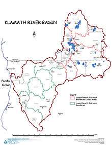 | |
|---|---|---|
| Significant cities | ||
| Major tributaries | ||
| Geography | ||
| Native American tribes | ||
| History | ||
| Dams and infrastructure |
| |
This article is issued from Wikipedia - version of the 4/13/2016. The text is available under the Creative Commons Attribution/Share Alike but additional terms may apply for the media files.