Klamath River
| Klamath River (Ishkêesh) | |
| Link River, Everglades of the West[1] | |
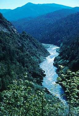 The Klamath River in California | |
| Name origin: For the Indian tribe called "Klamath" by early 19th-century white travelers[2] | |
| Country | United States |
|---|---|
| States | Oregon, California |
| Tributaries | |
| - left | Shasta River, Scott River, Salmon River, Trinity River |
| City | Klamath Falls |
| Source | Upper Klamath Lake |
| - location | Klamath Falls, Oregon |
| - elevation | 4,090 ft (1,247 m) [3] |
| - coordinates | 42°11′29″N 121°46′58″W / 42.19139°N 121.78278°W [4] |
| Mouth | Pacific Ocean |
| - location | Requa, California |
| - elevation | 0 ft (0 m) |
| - coordinates | 41°32′49″N 124°5′0″W / 41.54694°N 124.08333°WCoordinates: 41°32′49″N 124°5′0″W / 41.54694°N 124.08333°W [4] |
| Length | 263 mi (423 km) [5][6] |
| Basin | 15,688 sq mi (40,632 km2) [5] |
| Discharge | for near mouth (Klamath, CA) [7] |
| - average | 17,080 cu ft/s (484 m3/s) |
| - max | 557,000 cu ft/s (15,772 m3/s) |
| - min | 1,310 cu ft/s (37 m3/s) |
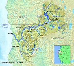 Map of the Klamath River watershed | |
The Klamath River (Karuk: Ishkêesh,[8] Klamath: Koke,[9] Yurok: Hehlkeek 'We-Roy[10]) flows 263 miles (423 km) through Oregon and northern California in the United States, emptying into the Pacific Ocean. By average discharge, the Klamath is the second largest river in California after the Sacramento River. It drains an extensive watershed of almost 16,000 square miles (41,000 km2) that stretches from the arid country of south-central Oregon to the temperate rainforest of the Pacific coast. Unlike most rivers, the Klamath begins in the plains and flows toward the mountains – carving its way through the rugged Cascade Range and Klamath Mountains before reaching the sea. The upper basin once contained vast freshwater marshes that provided habitat for abundant wildlife, including millions of migratory birds; now it is largely agricultural due to European settling, while the mountainous lower basin remains wild. The watershed is known for this peculiar geography, and the Klamath has been called "a river upside down" by National Geographic magazine.[11]
The Klamath is the most important coastal river south of the Columbia River for anadromous fish migration.[12] Its salmon, steelhead and rainbow trout have adapted to unusually high water temperatures and acidity levels relative to other rivers in the Pacific Northwest. The numerous fish were a major source of food for Native Americans, who have inhabited the basin for at least 7,000 years. The first Europeans to enter the Klamath River basin were fur trappers for the Hudson's Bay Company in the 1820s; they established the Siskiyou Trail along the Klamath and Trinity rivers into the Sacramento Valley. Within several decades of white settlement, native peoples were forced into reservations.
During the latter days of the California Gold Rush, increasing numbers of miners began working the Klamath River and its tributaries. Their impact on the surrounding environment was highly detrimental, as well as their impact Native American Klamath Tribes. The greed of the Gold Rush left most tribes with only 10% of the indigenous population. Steamboats operated briefly on the large lakes in the upper basin before they were replaced by railroads in the late 19th century. In the 19th and 20th centuries, the upper basin became a rich agricultural region, and many dams were built to provide irrigation water and hydroelectric power. In the 1960s, the Klamath was targeted as part of a much larger scheme to augment water supplies in central and southern California; however, these works never materialized.
Because the Klamath includes many of the longest free-flowing stretches of river in California, along with excellent whitewater runs, it has become a popular recreational river. However, dams and diversions in the upper basin have caused water quality issues on the lower half of the Klamath. Environmental groups and native tribes have proposed broad changes to water use in the Klamath Basin, principally the removal of some dams on the river to expand fish habitat. They put forth their concerns in what is now the Klamath Basin Restoration Agreement, a water management plan signed by local communities, governments, tribal groups, environmentalists, and fishermen. The proposal has been endorsed by the U.S. Department of the Interior but has not been authorized by the United States Congress.
Course

Upper Klamath Lake, filling a broad valley at the foot of the eastern slope of the southern High Cascades, is the source of the Klamath River. Its headstreams, however, begin over 100 miles (160 km) away—as far as Crater Lake and the Oregon–Nevada border. The first 1-mile (1.6 km) stretch of the Klamath River is known as the Link River. Not long after, however, the river is impounded in an 18-mile (29 km) long reservoir near Klamath Falls, Lake Ewauna, where it is connected by the B canal—which is capable of diverting water between the rivers in either direction as needed, to the Lost River and passes the nearly dry bed of Lower Klamath Lake.[4][13][14][15] After it flows out of this reservoir, it passes through four more hydroelectric dams[16] before it crosses the Oregon–California state border and turns south near the town of Hornbrook towards Mount Shasta. However, the river soon swings west to receive the Shasta River and the Scott River, cutting deep into the head of its canyon through the Klamath Mountains.[6]
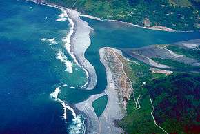
The route through the High and Western Cascades and the Klamath Mountains constitutes the majority of the river's course and takes it from the arid high desert climate of its upper watershed into a temperate rainforest nourished by Pacific rains. From the Scott River confluence, the river generally runs west along the south side of the Siskiyou Mountains until it takes a sharp southward turn near the town of Happy Camp. From there, it flows southwest over whitewater rapids into the Klamath National Forest, receiving the Salmon River, and passes the unincorporated community of Orleans. At Weitchpec, the river reaches the southernmost point in its entire course and veers sharply northwards as it receives the Trinity River. The Trinity River confluence also marks the point where the Klamath's current dramatically slows. For the remainder of its course, the Klamath flows generally northwest through the Hoopa Valley and Yurok Indian Reservations, passing the town of Klamath and flowing out to sea 16 miles (26 km) south of Crescent City.[13][17] The mouth of the Klamath River is at Requa,[18] in an area shared by the Yurok Reservation and Redwood National Park.[19] The Klamath River estuary is recognized for protection by the California Bays and Estuaries Policy.[20]
Watershed
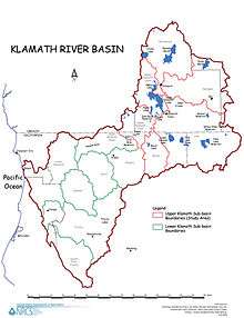
Extending from arid eastern Oregon to the cold and rainy Northern California coast, the Klamath River watershed drains parts of three Oregon counties and five counties in California and includes a diversity of landscapes. The northernmost part of the watershed is high desert country drained by the Williamson River and the Sprague River, both which flow generally southwest into Upper Klamath Lake. The middle basin is characterized by extensive wetland, grassland, and agricultural areas, and is partially filled by two major bodies of water: Upper and Lower Klamath Lake. The extensive lower basin, which encompasses over one half of the 15,751-square-mile (40,790 km2) watershed, is composed mainly of rugged mountains, forests and canyons.[17][21][22]
Several other West Coast and interior drainage basins border on that of the Klamath River. On the northwest are the Rogue River and Umpqua River in Oregon and the Smith River in California. On the east there is the closed Harney Basin and a small portion of the Great Basin. The south side of the Klamath River watershed is bounded by the Sacramento River and its upper tributaries, including the Pit River, and on the southwest side are the Mad River and Redwood Creek.[23] The western boundary of the upper Klamath Basin is formed by the High Cascades and the Klamath Mountains, one of the southernmost extents of the Cascade Range, and the California Coast Ranges cover the southwestern watershed. The Klamath is one of only three rivers that begins east of the Cascades and flows into the Pacific Ocean; the other two are the Columbia and the Fraser.[24]
Most human use of the watershed is limited to the upper basin. Despite the semiarid climate, dams have been built, irrigation water has been supplied from the Klamath and Lost rivers, and plentiful groundwater has been drawn to transform most of the upper Klamath Basin to farmland. At least 11,000 years ago, Lower Klamath and Tule Lakes in the rainy season would combine into one giant freshwater marsh that was nearly 290 square miles (750 km2) large. This, combined with the over 100 square miles (260 km2) of Upper Klamath Lake, formed a temporary habitat for millions of migratory birds.[25][26] These lakes are all remnants of a large Ice Age lake, Lake Modoc, that covered about 1,100 square miles (2,800 km2). Although all of the marshlands have been developed with the exception of Upper Klamath Lake,[27] about 3.7 million migrating birds still pass through the watershed each year.[28]

Despite its plentiful flow in California, the Klamath does not supply significant amounts of water to irrigators and municipal users in central and southern portions of the state. The Klamath Reclamation Project in the Klamath Falls area supplies water to local irrigators, and the Central Valley Project diverts water from the Trinity River to supply irrigation water to the Sacramento Valley.[29] Other tributaries of the Klamath, including the Lost and Shasta rivers, are also diverted for irrigation. Water use of the lower Klamath—one of the last relatively free-flowing rivers in the state of California—has been debated for decades among conservationists, tribes, irrigators, and government agencies, and its eventual fate is still unclear.
Tributaries
Tributaries of the Klamath River are listed below. Numbers (RM/RKM) after the tributary names denote the river miles (river kilometers) where they enter the Klamath, or the specific tributary under which it is listed.[30]
- Blue Creek (15.8/25.4)
- Trinity River (43.5/70.0)
- South Fork Trinity River (31.2/50.2)
- Hayfork Creek (30.0/48.3)
- New River (42.6/68.6)
- North Fork Trinity River (72.5/116.7)
- Canyon Creek (79.3/127.7)
- Reading Creek (93.8/151.0)
- Stuart Fork Trinity River (121.5/195.6)
- East Fork Trinity River (135.2/217.7)
- Coffee Creek (143.4/230.9)
- South Fork Trinity River (31.2/50.2)
- Red Cap Creek (52.5/84.5)
- Boise Creek (55.4/89.2)
- Salmon River (California) (66.0/106.3)
- Wooley Creek (5.0/8.1)
- North Fork Salmon River (19.6/31.6)
- Russian Creek (20.1/32.4)
- South Fork Salmon River (19.6/31.6)
- East Fork South Fork Salmon River (19.9/32.0)
- Copper Creek (86.2/138.8)
- Clear Creek (98.5/158.6)
- Elk Creek (105.5/169.8)
- Indian Creek (106.8/171.9)
- Scott River (142.0/228.5)
- South Fork Scott River (56.3/90.6)
- East Fork Scott River (56.3/90.6)
- Shasta River (176.3/283.7)
- Little Shasta River (14.0/22.5)
- Willow Creek (185.0/297.9)
- Jenny Creek (194.5/313.1)
- Lost River Diversion Channel (249.6/401.6)
- Lost River (12.0/19.3)
- Link River
- Upper Klamath Lake
- Wood River
- Annie Creek
- Sun Creek
- Crooked Creek
- Williamson River
- Sprague River (10.9/17.5)
- Sycan River (75.0/120.8)
- Klamath Marsh
- Big Springs Creek
- Sprague River (10.9/17.5)
- Wood River
Flooding
The lower and middle sections of the Klamath River are vulnerable to flooding, and major floods have occurred in years where major flooding has taken place in Northern California, particularly in the wake of Pineapple Express storms that bring large amounts of warm rain to Northern California. Significant floods on the Klamath River have occurred in 1926–1927, 1955, 1964, 1997, and 2005, in several cases changing the course of the river.[31][32][33][34] The Christmas flood of 1964 was particularly devastating, with a high water reaching 55 feet (17 m), inundating the towns of Klamath and Klamath Glen and destroying most of the Highway 101 bridge crossing the river. The highway bridge was rebuilt in a different location, though entrances to the old bridge still stand.[31][35]
The mouth of the Klamath and nearby sections of the river are susceptible to oceanic tsunami surges, and fatalities have occurred there during the 1964 and 2011 Pacific tsunamis.[36][37][38][39]
Geology
The Upper Klamath Basin, defined by the drainage area of the Klamath River above Iron Gate Dam, is a unique transitional area between the Cascade Range to the west and the Basin and Range Province of the northern Great Basin to the southeast. This region extends from the southern Lower Klamath Lake area into the Lost River and Upper Klamath Lake basins. Crustal stretching and block faulting created a topography with characteristics similar to both regions. Almost the entire basin is a graben region, bearing basin and range characteristics, formed by uplifting and subsidence along several north–south faults.[40]

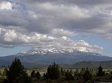
Pre-Quaternary, igneous and sedimentary rock compose the Yonna Formation, which crosses much of the region and rises above the surface in large outcroppings of solid rock in many of the ridges.[41] Underlying rocks are generally younger from east to west. The many ridges crossing the upper Klamath Basin divide it into valleys with up to 330 feet (100 m) of vertical relief, and drainage patterns generally follow the topography. An extensive geothermal system occurs deep underground within the upper basin, creating hot springs and artesian springs, but is not well understood.[42] Further south, in the Shasta River area in Siskiyou County, much of the underlying rock is composed of lava flows issuing from the Mount Shasta volcanic region.[43]
The same age pattern is true in the Cascade Range and Klamath Mountains that cover the western half of the Klamath River watershed. As the North American Plate moved slowly southwestward over the past 10 million years, successive oceanic terranes dating from the Cambrian to the late Jurassic were added to the bulk of the North American continent. There are four distinct terranes from west to east. While the coastal mountains date to less than 3 million years ago, the farther inland High Cascades are as old as 7.5 million years. Granite batholiths, overlying sedimentary rock, and volcanic rock were crumpled into the massif of southwestern Oregon and northwestern California.[44] Instead of being diverted southwards, however, the Klamath continued to flow westward and created a steep-walled gorge through the rising range. One of these terranes brought with it a long north–south running band of easily eroded mica that now lies about 30 miles (48 km) inland from the Pacific coast of Northern California.[45][46] When the Klamath encountered this layer, it began cutting its canyon along the mica instead of continuing southwest to the Pacific, resulting in the sharp northward bend where the Trinity River joins. The lower Trinity also follows portions of the mica and its south fork as well.
History
Early inhabitants and settlers
Human habitation on the Klamath dates to at least 7,000 years ago. Many of the Native American groups along the river depended on the vast runs of Pacific salmon, second only to that of the Columbia River. These Tribes included the Shasta along the mid and upper river, the Yurok, Hupa, and Karuk along the canyons of the lower river and the Modoc, Klamath and Yahooskin in the arid valleys of the upper basin. The Shasta Tribe controlled 129 miles (208 km), over half of the middle and upper Klamath River flowing through the great Shasta Tribal lands. The Yurok were probably one of the more powerful Tribes on the Klamath River behind the Shasta Tribe, controlling about 30 miles (48 km) of the lower Klamath River and a large section of the Northern California coast. Along with the Hupa and Karuk, the lower to mid-upper Tribes caught salmon from the river with weirs, basket traps and even harpoons.[47][48] One well-known ancient fishing ground is Ishi Pishi Falls, a set of rapids on the river near the confluence with the Salmon River. Most of the upstream groups had a nomadic hunting-gathering lifestyle and did not depend on salmon as much as downstream Tribes.[49] The Klamath River's name was recorded by Europeans in the 19th century derived from the word klamet or the Klamath Tribe, but prior to white contact, many names were used to refer to the river, including Ishkêesh and Koke. The Klamath Tribe's name came from the Upper Chinookan word /ɬámaɬ/, literally "they of the river".[50]
In the late 1820s, fur trappers of the Hudson's Bay Company traveling south from Fort Vancouver reached the Klamath River basin. The first party to see the Klamath River was led by Alexander McLeod in the winter of 1826–27. In 1828, the Jedediah Smith fur trapping expedition was helped across the Trinity River by the Yurok and camped on the east side of the Trinity River. His clerk, Harrison G. Rogers, wrote, "Mr. Smith purchases all the beaver furs he can from them," suggesting that beaver were then plentiful on the Trinity. Joseph Grinnell, in Fur-bearing Mammals of California, noted that beaver had been present on other Klamath River tributaries such as the Scott River and Shasta River, and further cited a Fish and Game report of beaver from 1915–1917 on High Prairie Creek[51] at the mouth of the Klamath River near Requa, California.[52] Within a matter of years, the plentiful beavers in the Klamath Basin had been mostly wiped out. Beaver dams had previously been an important factor in stream habitat in the Klamath River watershed, helping to moderate the power of floods and creating extensive wetlands. The loss of the beaver dams resulted in detrimental consequences for watercourses in the basin, exacerbating the power of winter floods, and causing severe erosion. Trapping parties eventually moved southwest into the Sacramento Valley and blazed an extension of the Siskiyou Trail, an early path between the Oregon Territory and San Francisco Bay. Despite the environmental implications, extensive and fertile meadows left behind by the draining of beaver ponds attracted many settlers to the region later on.[48][53]
Klamath River ever since the discovery of gold in its bed has been continuously mined and is still a long way from being worked out. The conditions for river mining in this stream are very favorable. Though carrying a large volume of water, it has nearly everywhere a considerable grade and velocity of current with no great depth…
…At the present time there are about twenty-five claims being worked on the Klamath and Salmon Rivers, employing three hundred men. Operations in this locality are generally on a small scale and involve the use of but little capital.
—R.L. Dunn (1889)[54]
The 1850s saw discoveries of rich placer and lode gold deposits along the predominantly Shasta areas of the Klamath, Trinity, Shasta and other rivers in northwestern California. The 1850s also brought a greed-fueled murderous rampage upon the indigenous people inhabiting the regions. Villages full of men, women, children, and infants were either hacked up or shot for the potential gold that would be harmfully extracted. The gold is thought to have originated from volcanic activity in the Klamath Mountains.[55] Miners searching for gold in the Klamath Mountains and Trinity Alps in the aftermath of the California Gold Rush first discovered gold along Salmon Creek in the spring of 1850, and additional deposits were found on the main stem by July. Gold was also discovered in great quantities in Shasta lands at French Gulch and Yreka.[56] Several place names in the Klamath Basin originate from this era, including that of the Scott River, which is named for pioneer John Walter Scott.[57] Gold deposits are still present in the Klamath River watershed even though it was mined far past the end of the gold rush.[58]
In 1864, the Native Americans of the Klamath Basin and surrounding area signed a treaty that had them cede 20 million acres (8,100,000 ha) of land to the United States and forced them to move to the newly created Klamath Indian Reservation. This reservation clumped the Yurok, Karuk, and Hoopa tribes into one small area. Eventually, the tribes began to profit from the sale of timber produced on the reservation, although unfairly distributed because of the lack of consideration of the three differing tribes. In 1954, however, Congress removed their federal recognition and the reservation was no longer economically successful. The tribes won back federal recognition in the 1970s, but by then poverty was widespread among tribal members.[59]
Early industry and development
_PC_1908.JPG)
Beginning in the early 20th century, steamboats began operating on Lower Klamath Lake between Siskiyou County, California, and Klamath Falls, Oregon. The steamboats completed a link between Klamath Falls and a railroad branch line following the McCloud River—the final part of which was called the Bartle Fast Freight Road, after Bartle, California. The end of this line, Laird's Landing, was the beginning of the Lower Klamath Lake steamboat line, which began operating with an 80-foot (24 m) screw steamer in 1905. By 1909, however, the railroad had circumnavigated Lower Klamath Lake directly to Klamath Falls. The steamboat line fell into disuse—and much of Lower Klamath Lake was later drained and filled in.[60]
In the early 1910s and 1920s, logging was a growing industry on the west side of the upper Klamath River valley, especially around Upper Klamath Lake. The Great Northern Railway and Southern Pacific Railroad built a joint-use line running along the eastern shore of the lake, delivering logs from the north side to a sawmill 3 miles (4.8 km) downstream from the outlet of the lake. Many of the seasonal marshlands surrounding the lake and rivers were diked in this period to host lumber operations.[61] In 1919, the first Link River Dam, a timber crib dam, was constructed at the outlet of Upper Klamath Lake, raising it by about 16 feet (5 m). Steamboats continued mail, passenger and freight operations on Upper Klamath Lake until about 1928, in a period when many of the lumber companies shut down due to drought.[62]
With lumber a declining industry in the upper Klamath Basin, the economy slowly transitioned to agriculture. The Klamath Reclamation Project, established by the Bureau of Reclamation in the early 20th century, involved the construction of two dams on the river and additional dams on many of its tributaries, as well as the final draining of Lower Klamath and Tule Lakes.[63] The Bureau of Reclamation was not the only user of the river during this period; in the late 1950s PacifiCorp and California-Oregon Power Company (COPCO) constructed three more dams on the river downstream.[64] These dams, however, sparked a great controversy over water quality in the lower section of the river and the dependence of the river's annual salmon runs on it.[65]
Natural history
The river is considered a prime habitat for Chinook salmon, Coho salmon, and rainbow trout. Once the river was the third-largest producer of salmon on the West Coast,[66] but today, only a fraction of the river's historic runs remain since the construction of six dams between 1908 and 1962. Coho salmon in the Klamath River are listed as threatened under the Endangered Species Act. In 1963, the upper Trinity River—the largest single tributary to the Klamath—was virtually removed from the Klamath drainage with the completion of the Lewiston and Trinity Dams, diverting 90 percent of the Trinity's flow to the Sacramento Valley. From 1963 to 1991, only 150 cubic feet per second (4.2 m3/s) from the main stem above the dams was left to flow to the Klamath. In 1991, a minimum annual Trinity flow of 340,000 acre feet (420,000,000 m3) was established, or about 470 cubic feet per second (13 m3/s).[67]
From the 1920s to the 1960s, four hydroelectric dams were built by the California-Oregon Power Company (COPCO) and its successor PacifiCorp on the Klamath River main stem, blocking salmon migration and trapping sediment that formerly replenished downstream gravel bars used by spawning salmon. The possible removal of the dams has been a controversial issue in the region in recent years. Despite intense lobbying by local Native American tribes, conservationists, and fishermen, the 2004 renewal application by PacifiCorp for another 50-year federal operating license for the dams did not include any provisions for allowing salmon to return to more than 300 miles (483 km) of former habitat above the dams. In January 2007, however, the federal government ruled that PacifiCorp must equip four dams with fish ladders, a modification which would potentially cost more than $300 million. PacifiCorp has offered $300 million to upgrade the JC Boyle fish ladder and proposed trucking fish around the Copco Number 1 and Iron Gate dams, after having had been denied a license to build a power generator in Utah. PacifiCorp President Fehrman defended the company's activities in the area, pointing to other benefits.[68]
A separate controversy surrounds the use of water in the Upper Klamath Basin for irrigated agriculture, which was temporarily halted in 2001 to protect endangered salmon and lake fish during a severe drought. Vice President Dick Cheney personally intervened to ensure water to the agriculture industry rather than to environmental flow.[69] In 2002, the federal government, under Interior Secretary Gale Norton, provided full water deliveries to irrigators as the drought continued; despite the fact that Klamath area tribes have treaty rights that predate the settlement of the farmers. Norton argued for a "free market" approach by allowing farmers to sell the water to the Native Americans downstream.[70][71] That year, the Klamath River system had the largest fish die-off ever recorded. The House Natural Resources Committee investigated Vice President Cheney for having released extra water to ranchers for possible political gain.[72]
According to biologists from the State of California and the U.S. Fish and Wildlife Service,[73] the atypical low flow in the river along with high fish return numbers and high water temperatures allowed for a gill rot disease to kill at least 33,000 salmon in September 2002, before they could reproduce. The die-off was downstream of the Trinity inflow, and the salmon of the Trinity were impacted to a greater degree than the Klamath as the Trinity run was at its peak. The report does mention that the official fish die-off estimate of 34,056 is probably quite low and could be only half of the actual loss. Klamath River flows as measured at the river gauge in Keno show a low flow of 800 cubic feet per second (22.7 m3/s) in September 1908 (before irrigation began). During the 2002 fish kill, flows of 475 cubic feet per second (13.5 m3/s) were recorded. During September of the 2001 irrigation shut-off, an average of 688 cubic feet per second (19.5 m3/s) was recorded.[74]
In 2011, the U.S. Environmental Protection Agency (EPA) approved a plan first introduced in 1992 by California's state government. The plan called for major cleanup of the lower river in order to protect salmon from phosphorus, nitrogen, and carbonaceous biochemical oxygen demand.[1] It also expressed concern over high water temperatures, algal blooms, and low oxygen levels, although certain fish have adapted to some of these issues.[75][76] Environmental groups, more than six government agencies, Native American tribes in the basin, and others have worked with the EPA to reduce pollution levels in the Klamath.[75]
Salmon controversy
The remaining water left in the river, whatever the Project is willing to release from Iron Gate Dam, is so little in volume, so hot and so laced with pesticides and nitrates from agricultural waste water that it is often fatal for salmon as much as 100 miles (160 km) downriver. Hundreds of thousands of salmon have been killed in recent years as a result, and Klamath River coho salmon driven nearly to extinction.
—Pacific Coast Federation of Fishermen's Associations (2008)[66]
Historically, the Klamath River was once the "third most productive salmon river system in the United States", after the Columbia and the Sacramento.[66] Eutrophication and raised water temperatures induced by the construction of dams have created worsening conditions for migrating salmon, especially in years of drought.[77][78][79] Irrigation along the upper Klamath and the Shasta and Scott rivers, along with the almost-total diversion of the upper Trinity River,[67] have all lowered the total river flow supporting out-migrating young salmon in spring and in-migrating adult salmon in the fall.[80] In the 1960s, a project was proposed to divert the entire Klamath River to Central California and Southern California, an undertaking known as the Klamath Diversion, but this project was defeated. It would have limited salmon to the last 12 miles (19 km) of the entire river.[81] In 2002, a major fish kill took its toll on the river and the Tribes that depend on it. More than 34,000 salmonoids died alone, due to the low waters and poor hindsight, as well as compassion, of those in charge(PacifiCorp). In 2005, PacifiCorp applied to the federal government to relicense its four hydroelectric dams on the Klamath for up to 50 years. Environmentalists opposed the relicensing, arguing that the dams should be removed to reopen the upper Klamath to salmon.[82]


An agreement was signed on February 18, 2010.[83]
Two years of closed-door negotiations among farmers, Indian tribes, fishermen, conservation groups and government agencies had resulted in a plan to work toward a detailed settlement of Klamath water usage. It also called for the removal of four hydroelectric dams—the Iron Gate Dam and Copco dams 1 and 2 (in California), and the John C. Boyle Dam (in Oregon)—now operating along 300 miles (483 km) of the Klamath River, starting in the year 2020, as well as for restoration projects.[84] A non-binding "Agreement in Principle" (AIP) among four parties—PacifiCorp, the federal government, California, and Oregon—to remove the four dams had been announced on November 13, 2008.[85][86] PacifiCorp ratepayers would fund part of the plan and the State of California would fund much of the remaining projected cost. Total cost would be around $800 million. The agreement required the federal government to scientifically assess the costs and benefits of the dam removals, determine whether such action is in the public interest, and to make a final determination by March 31, 2012, as to whether the benefits of the project will justify the costs, although that deadline was missed. A local group, the Klamath County Tea Party Patriots, formed to oppose the agreement, and succeeded in unseating local elected officials who were supportive of the deal.[12] On December 31, 2012, the parties renewed their agreement, providing more time for federal, Congressional, and California electorate approval to finalize dam removal.[85][87]
On April 4, 2013, the U.S. Department of the Interior released its final environmental impact statement on the plan, recommending the removal of all four dams and $1 billion in other environmental restoration to aid native salmon runs on the Klamath.[88] Ron Wyden, the senior U.S. senator from Oregon, introduced the Klamath Basin Water Recovery and Economic Restoration Act of 2014, which was cosponsored by his fellow Oregon senator Jeff Merkley and by Nevada senator Dean Heller.[89]
Water rights dispute
When the 1864 treaty was signed, the Klamath Tribes, with much less land, became short on the stream water needed for fishing. Although from the 1950s to the 1970s they were not federally recognized, the tribes never lost their water rights, and in 2001, when Klamath Basin farmers twice sued the U.S. Department of the Interior for more access to irrigation water, their rights were upheld.[90] The tribes' water allotments for fishing continue to be a large factor in Klamath Basin water disputes in the 21st century.[91] In 2013, the Tribe's water rights were enforced for the first time, in what is known as a 'Water Call'. The Klamath Tribe called upon their in-stream water right, which was enforced by the Water Master. This resulted in almost all upper-basin irrigation being denied water, except for groundwater irrigators. The Klamath Project, however, was not called upon.
Recreation
Whitewater rafting and kayaking are popular recreational activities along the upper Klamath River below the J.C. Boyle Dam, and also along the lower Klamath River downstream of the town of Happy Camp. There are long stretches—over 100 miles (160 km) in one instance—of Class I–II whitewater rapids, while there are some Class III–IV rapids in some of the narrower stretches. Beyond Weitchpec, the river slows down into a wider, deeper channel. About 13 miles (21 km) of the river is designated Wild, and 175 miles (282 km) Recreational.[92]
Sport fishing is also popular on the Klamath River, with steelhead trout being the most popular, though Chinook salmon are also highly sought after when low salmon returns do not prevent fishing. A fly fishing guide said that the Klamath was one of the most productive steelhead rivers on the West Coast of the United States.[93]
Recreational gold mining is popular along the Klamath and some of its tributaries, including the Salmon and the Trinity. Although simple methods such as panning are still used, some methods use suction pumps—a practice involving turning over deposits of sediment and spreading them in order to find gold. Debates over the practice, which opponents contend damage water quality (mercury) and fish habitat, continue.[94] Currently, suction dredge mining is banned in California until 2016.[95]
A variety of national forests and wildlife preserves—including the Klamath National Forest, Six Rivers National Forest, Klamath National Wildlife Refuges Complex, and Lower Klamath National Wildlife Refuge—are located in the Klamath River watershed. The Klamath National Forest is located in Siskiyou County with a small portion in Oregon, and Six Rivers National Forest is located in the southern Klamath watershed, mostly in the Trinity River watershed. The latter two are located in the Upper Klamath Lake-Lower Klamath Lake area. Lava Beds National Monument, which contains a large array of lava tubes and formations, is also in the Lower Klamath Lake area, to the south of the remnants of the lake.
Klamath River Overlook
The Klamath River Overlook is a prime spot open to the public for watching the gray whale migration. Look for other marine mammals and a host of seabirds any time of year. Hike ¼ mile down a steep trail to the lower overlook and more dramatic views.
The Yurok Tribe's Klamath Salmon Festival
A annual festival[96] takes place along the Klamath River.
See also
- List of California rivers
- List of longest streams of Oregon
- List of National Wild and Scenic Rivers
- List of rivers of Oregon
References
Notes
- 1 2 "EPA approves historic salmon restoration plan for Klamath River". U.S. Environmental Protection Agency. 2011-01-04. Retrieved 2011-07-28.
- ↑ McArthur, pp. 541–542
- ↑ Source elevation derived from Google Earth search using GNIS coordinates.
- 1 2 3 "Klamath River". Geographic Names Information System. United States Geological Survey. 1981-01-19. Retrieved 2011-07-27.
- 1 2 "Klamath Basin: A Watershed Approach to Support Habitat Restoration, Species Recovery, and Water Resource Planning" (PDF). U.S. Geological Survey. 2007-08-09. p. 1. Retrieved 2015-07-16.
- 1 2 Powers, Kyna; Baldwin, Pamela; Buck, Eugene H.; Cody, Betsy A. (2005-09-22). "Klamath River Basin Issues and Activities: An Overview" (PDF). California Department of Energy. Archived from the original (PDF) on 2013-05-23.
- ↑ "Water-Data Report 2013: 11530500 Klamath River near Klamath, CA" (PDF). U.S. Geological Survey. pp. 1, 3. Retrieved 2014-02-12. The average discharge is an annual mean based on data from water years 1963 through 2013. The minimum flow was recorded on 1977-09-04, and the maximum was on 1964-12-23.
- ↑ Bright, William; Susan Gehr. "Karuk Dictionary and Texts". Retrieved 2012-07-06.
- ↑ McArthur, p. 542
- ↑ "Yurok Dictionary: Hehlkeek 'We-Roy". Retrieved 2012-07-07.
- ↑ Rymer, Russ. "Reuniting a River: After fighting for years over its water, farmers, Indians and fishermen are joining forces to let the troubled Klamath River run wild again". National Geographic. National Geographic Society (December 2008). Retrieved 2009-08-21.
- 1 2 http://www.nytimes.com/2012/07/19/us/two-years-after-pact-to-restore-river-no-changes.html
- 1 2 "Klamath River Dam and Sediment Investigation" (PDF). The Yurok Tribe. November 2006. Retrieved 2009-08-21.
- ↑ Hydrology, Ecology and Fishes of the Klamath River Basin, p. 27
- ↑ "Ground-Water Hydrology of the Upper Klamath Basin, Oregon and California". Scientific Investigations Report 2007–5050. U.S. Geological Survey. 2010-04-07. Retrieved 2008-06-29.
- ↑ "Klamath River, OR and CA". American Rivers. Retrieved 2013-08-30.
- 1 2 Hydrology, Ecology and Fishes of the Klamath River Basin, p. 37
- ↑ Durham, David L. (1998). California's Geographic Names: A Gazetteer of Historic and Modern Names of the State. Clovis, Calif.: Word Dancer Press. p. 131. ISBN 1-884995-14-4.
- ↑ "Yurok Tribe: tribal park concept plan" (PDF). The Yurok Tribe. August 2005. Retrieved 2011-07-16.
- ↑ "Water Quality Control Policy for the Enclosed Bays and Estuaries of California" (PDF). California Environmental Protection Agency, State Water Resources Control Board. p. 1. Retrieved 2013-08-18.
- ↑ Hydrology, Ecology and Fishes of the Klamath River Basin, p. 26
- ↑ "Overview of the upper Klamath Basin" (PDF). United States Department of Agriculture Natural Resources Conservation Service. Retrieved 2009-08-21.
- ↑ North America watersheds (2006) – Commission for Environmental Cooperation (Map). Cartography by CEC, Atlas of Canada, National Atlas, Instituto Nacional de Estadística y Geografía. Commission for Environmental Cooperation (CEC). 2010-12-10. Archived from the original on 2012-10-07.
- ↑ The Columbia River rises in the Rocky Mountain Trench of the Canadian Rockies several hundred miles east of the Cascades, while the Fraser begins in the Rocky Mountain Trench farther north. Both rivers cut through the Cascades to flow to the Pacific Ocean (in the case of the Fraser, the mountains there are called the Canadian Cascades, but geophysically they are part of the same range.) The Klamath’s uppermost tributaries begin just to the northwest of the Great Basin, well to the east of the High Cascades. Rivers like the Rogue and Umpqua in Oregon that cut through the Coast Range and begin on the western slopes of the High Cascades should not be confused as cutting through the Cascades although they do flow through the parallel range.
- ↑ "Refuge History: Klamath Basin National Wildlife Refuges". U.S. Fish and Wildlife Service. 2009-04-01. Archived from the original on 2013-06-24.
- ↑ Delong, Jay. "Walking in 100-Year-Old Footsteps in Southern Oregon". North American Native Fishes Association. Retrieved 2009-08-21.
- ↑ "Klamath Lake". Oregon Lakes Association. Retrieved 2012-12-24.
- ↑ Blake and Kittredge, p. 1
- ↑ "Shasta/Trinity River Division Project". U.S. Bureau of Reclamation. 2011-04-21. Retrieved 2009-08-21.
- ↑ USGS Topo Maps for United States (Map). Cartography by United States Geological Survey. ACME Mapper. Retrieved 2013-10-13.
- 1 2 "Floods on the Klamath River". Klamath Bucket Brigade. Retrieved 2015-07-16.
- ↑ "Floods in northern California, January 1997" (PDF). U.S. Geological Survey. April 1999. Retrieved 2011-07-17.
- ↑ Stumpf-Foley, Marcie. "Klamath River Flood of 1997". Gold and Treasure Hunter. The New 49ers. Retrieved 2011-07-17.
- ↑ "Klamath River flood 2005–2006". Happy Camp News. Happy Camp, California: Klamath Design. 2006-01-02. Retrieved 2011-07-17.
- ↑ "Redwood National Park: Klamath River". ParkVision. Retrieved 2011-07-17.
- ↑ Powers, pp. 62–70
- ↑ Fox 5 San Diego; CNN Wire (2011-03-11). "California tsunami death: NorCal man drowns trying to photograph tsunami". Hartford Courant. Hartford, Connecticut. Archived from the original on 2013-06-06.
- ↑ Associated Press (2011-03-13). "Man swept out to sea by tsunami was Bend native". OregonLive.com. Retrieved 2013-08-18.
- ↑ "Klamath tsunami victim identified; search comes up empty". The Times-Standard. Eureka, California. 2011-03-13. Retrieved 2015-07-16.
- ↑ "Upper Klamath Basin Ground-Water Study". Oregon Water Science Center. U.S. Geological Survey. 2008-10-31. Retrieved 2009-11-10.
- ↑ Newcomb, R. C. (1958). "Yonna Formation of the Klamath River Basin, Oregon" (PDF). U.S. Geological Survey. Archived from the original (PDF) on 2014-09-03.
- ↑ "Klamath Falls Geologic Map Project". Oregon Department of Geology and Mineral Industries. Archived from the original on 2009-01-05. Retrieved 2009-11-11.
- ↑ "Upper Klamath River 8-Digit Hydrologic Unit Profile" (PDF). Natural Resources Conservation Service. U.S. Department of Agriculture. February 2006. Retrieved 2009-11-11.
- ↑ Irwin, Snoke, and Barnes, p. 289
- ↑ Irwin, Snoke, and Barnes, p. 16
- ↑ Covington, Sid (2004-04-20). "Whiskeytown National Recreation Area Geologic Resources Management Issues Scoping Summary" (PDF). Geologic Resources Division. U.S. National Park Service. Retrieved 2009-11-11.
- ↑ "MSU Archives Collection 219". Minnesota State University, Mankanto. 2009-07-21. Retrieved 2011-07-27.
- 1 2 Litton, Sabrina (Spring 2003). "A Review of the History of Water Use throughout the Klamath River Basin" (PDF). Center for Watershed Sciences. University of California, Davis. Retrieved 2010-05-19.
- ↑ Darling, Dylan (2005-06-19). "Your land, my land?". Herald and News. Klamath Falls, Oregon. Retrieved 2011-07-27.
- ↑ Bright, p. 228
- ↑ "High Prairie Creek". Geographic Names Information System. United States Geological Survey.
- ↑ Grinnell, p. 724
- ↑ Mackie, p. 66
- ↑ Dunn, R.L (1890). "River Mining". Ninth Annual Report of the State Mineralogist for the year ending December 1, 1889. Sacramento, California: William Irelan, Jr., California State Mining Bureau; State Printing Office. p. 263. Retrieved 2014-11-10.
- ↑ Hittell, p. 141
- ↑ "Gold Mines and Gold Prospecting in California – Region 6". Goldmaps.com. Retrieved 2009-08-22.
- ↑ Durham, p. 307
- ↑ Hall, Monica; Jenner, Gail. "Early Gold Mining on the Trinity and Klamath Rivers". Klamath Bucket Brigade. Retrieved 2015-07-16.
- ↑ Donnelly, Robert. "Klamath Indian Reservation". The Oregon History Project. Oregon Historical Society. Retrieved 2012-02-08.
- ↑ "Steamboats on Klamath Lake". Siskiyou County Sesquicentennial Committee. Archived from the original on 2011-07-16. Retrieved 2012-02-09.
- ↑ Blake and Kittredge, p. 9
- ↑ Boyle, John C. "Regulation of Upper Klamath Lake". Klamath Bucket Brigade. Retrieved 2015-07-16.
- ↑ "A brief historical overview of Klamath County, Oregon" (PDF). Klamath Falls, Oregon: Klamath County Museum. 2010-10-01. pp. 2–3, 7. Archived from the original (PDF) on 2013-11-11.
- ↑ Kramer, George (October 2003). "Klamath Hydroelectric Project: FERC No. 2082" (PDF). Portland, Oregon: PacifiCorp. Retrieved 2011-07-18.
- ↑ "Klamath Water v. Patterson". U.S. Court of Appeals for the Ninth Circuit. 2000-01-28. Archived from the original on 2012-03-14.
- 1 2 3 "The struggle to save salmon in the Klamath Basin". The Pacific Coast Federation of Fishermen's Associations. 2008-04-15. Archived from the original on 2009-08-01. Retrieved 2009-08-21.
- 1 2 Stene, Eric (1994). "Central Valley Project: Trinity River Division". U.S. Bureau of Reclamation History Program. Archived from the original on 2008-05-03. Retrieved 2008-06-29.
- ↑ Barnard, Jeff (2007-02-10). "PacifiCorp willing to build fish ladders". The Daily Triplicate. Crescent City, California. Associated Press. Retrieved 2008-06-29.
- ↑ Becker, Jo; Gellman, Barton (2007-06-27). "Leaving no tracks". The Washington Post. p. A1. Archived from the original on 2008-05-15.
- ↑ "The Truth About Klamath Project Irrigation Water Deliveries in 2001" (PDF). Klamath Basin Coalition Fact Sheet. Klamath Basin Coalition. 2003-05-15. Retrieved 2009-11-12.
- ↑ Taylor, James M. (2002-02-01). "NAS panel investigates Klamath water shutoff". Environment and Climate News. Heartland Institute. Retrieved 2009-11-12.
- ↑ Kovner, Guy (2007-07-09). "Cheney's role in fish kill probed 2002 Klamath River disaster". The Press Democrat. Santa Rosa, California. Retrieved 2014-09-05.
- ↑ "September 2002 Klamath River Fish-Kill: Final Analysis of Contributing Factors and Impacts" (PDF). Pacific Coast Federation of Fishermen's Associations. July 2004. Archived from the original (PDF) on 2008-12-19. Retrieved 2009-08-23.
- ↑ "USGS Gage #11512500 on the Klamath River below Fall Creek near Copco (Average Annual Streamflow)" (1924-01-02 to 1960-12-01). National Water Information System. United States Geological Survey. Retrieved 2009-08-23.
- 1 2 "Action plan for the Klamath River total maximum daily loads and Lost River implementation plan" (PDF). California Environmental Protection Agency, State Water Resources Control Board. March 2010. pp. 1–2. Retrieved 2011-07-28.
- ↑ "Klamath River, Oregon". National Wild and Scenic Rivers System. Retrieved 2013-07-10.
- ↑ National Research Council, p. 263
- ↑ Foster, Doug (2002). "Refuges and Reclamation: Conflicts in the Klamath Basin, 1904–1964" (PDF). Oregon Historical Quarterly. Oregon Historical Society. 103 (2): 150–187. Retrieved 2008-06-29.
- ↑ "Restoring Balance to the Klamath Basin". Oregon Wild. Retrieved 2008-06-29.
- ↑ "Klamath Project". U.S. Bureau of Reclamation. Archived from the original on 2008-03-11. Retrieved 2008-06-29.
- ↑ Reisner, pp. 267–268
- ↑ Whitney, David (2007-08-12). "Discord threatens Klamath River water talks: Refuge farms "a deal-killer"". Sacramento Bee. p. A4. Archived from the original on 2007-09-13.
- ↑ Barnard, Jeff (February 19, 2010). "Klamath Basin deal helps farmers, fish". The World. Associated Press. Retrieved 2011-07-27.
- ↑ "Proposed Klamath River Basin Restoration Agreement for the Sustainability of Public and Trust Resources and Affected Communities" (PDF). 2008-01-15. Retrieved 2008-06-29.
- 1 2 Unkefer, Charlie (2008-11-20). "'Historic' dam removal decision". Mount Shasta Herald. Mount Shasta, California.
- ↑ Yardley, William (2011-07-30). "Removing barriers to salmon migration". The New York Times. p. A10. Retrieved 2011-07-30.
- ↑ Barnard, Jeff (2012-12-31). "Parties renew Klamath Basin accord". The Register-Guard. Eugene, Oregon. Associated Press. p. B2. Retrieved 2013-01-02.
- ↑ Barnard, Jeff (2013-04-04). "Remove all four dams on the Klamath River, environmental analysis recommends". The Oregonian. Associated Press. Retrieved 2013-04-05.
- ↑ http://www.siskiyoudaily.com/article/20140604/News/140609860
- ↑ "Klamath Tribes' water rights". The Klamath Tribes. Archived from the original on 2011-07-21.
- ↑ "Klamath Tribes assert water rights, shutting off irrigation to some ranchers". The Oregonian. Associated Press. 2013-06-13. Retrieved 2013-07-10.
- ↑ Palmer, p. 141
- ↑ "Saving the Klamath River: An Interview With Fly Fishing Guide Craig Nielsen". California Trout. Retrieved 30 March 2012.
- ↑ Bacher, Dan (2009-03-24). "Klamath Riverkeeper Joins Suit to Stop Harmful Recreational Gold Mining" (PDF). Klamath Riverkeeper. Retrieved 2009-08-22.
- ↑ "Suction Dredge Permits". California Department of Fish and Game. Retrieved 2015-07-16.
- ↑ "The Yurok Tribe's Klamath Salmon Festival". www.yuroktribe.org. Retrieved 2016-03-02.
Works cited
- Blake, Tupper Ansel; Blake, Madeleine Graham; Kittredge, William (2000). Balancing Water: Restoring The Klamath Basin. Berkeley, California: University of California Press. ISBN 978-0-520-21314-2. OCLC 247677277.
- Board on Environmental Studies and Toxicology (BEST); Water Science and Technology Board (WSTB) (2008). Hydrology, Ecology and Fishes of the Klamath River Basin. Washington, D.C.: National Academies Press. ISBN 978-0-309-11507-0. OCLC 190778059.
- Bright, William (2004). Native American Placenames of the United States. Norman, Oklahoma: University of Oklahoma Press. ISBN 978-0-8061-3598-4. OCLC 53019644.
- Durham, David L. (1998). California's Geographic Names: A Gazetteer of Historic and Modern Names of the State. Clovis, California: Word Dancer Press. ISBN 978-1-884995-14-9. OCLC 38389700.
- Grinnell, Joseph; Dixon, Joseph S.; Linsdale, Jean M. (1937). Fur-bearing Mammals of California: Their Natural History, Systematic Status, and Relations to Man. 2. Berkeley, California: University of California, Berkeley. OCLC 1836075.
- Hittell, Theodore Henry (1897). History of California. 3. N.J. Stone.
- Irwin, William Porter; Snoke, Arthur W.; Barnes, Calvin G. (2006). Geological Studies In The Klamath Mountains Province, California And Oregon. Boulder, Colorado: Geological Society of America. ISBN 978-0-8137-2410-2. OCLC 70407916.
- Mackie, Richard Somerset (1997). Trading Beyond the Mountains: The British Fur Trade on the Pacific 1793–1843. Vancouver, British Columbia: University of British Columbia (UBC) Press. ISBN 978-0-7748-0613-8. OCLC 82135549.
- McArthur, Lewis A.; McArthur, Lewis L. (2003) [1928]. Oregon Geographic Names (7th ed.). Portland, Oregon: Oregon Historical Society Press. ISBN 978-0875952772.
- National Research Council (NRC) (2004). Endangered and Threatened Fishes in the Klamath River Basin: Causes of Decline and Strategies for Recovery. Washington, D.C.: National Academies Press. ISBN 978-0-309-09097-1. OCLC 54280138.
- Palmer, Tim (1993). The Wild and Scenic Rivers of America. Washington, D.C.: Island Press. ISBN 978-1-55963-145-7. OCLC 26586845.
- Powers, Dennis M. (2005). The Raging Sea: The Powerful Account of the Worst Tsunami in U.S. History. New York, New York: Citadel Press. ISBN 0-8065-2682-3. OCLC 57588825.
- Reisner, Marc (1986). Cadillac Desert. New York, New York: Viking Press. ISBN 978-0-670-19927-3. OCLC 13423435.
- U.S. Coast and Geodetic Survey (UCGS) (1951-06-02). United States Coast Pilot: Pacific Coast (7th ed.). Washington, D.C.: U.S. Government Printing Office. OCLC 54088263.
External links
| Wikimedia Commons has media related to Klamath River. |
- Klamath RiverKeeper
- Mid Klamath Watershed Council
- State of California hydrological monitoring of the Klamath and tributaries.
- NASA Earth Observatory: drought and irrigation shut off in the Klamath Basin
- Earth Island Journal – The Story Behind the World's Biggest Dam Removal – Rough Water
| States and counties | | |
|---|---|---|
| Significant cities | ||
| Major tributaries | ||
| Geography | ||
| Native American tribes | ||
| History | ||
| Dams and infrastructure |
| |