Ironshire, Maryland
| Ironshire, Maryland | |
|---|---|
| Unincorporated community | |
 Ironshire | |
| Coordinates: 38°17′02″N 75°13′52″W / 38.28389°N 75.23111°WCoordinates: 38°17′02″N 75°13′52″W / 38.28389°N 75.23111°W | |
| Country | United States |
| State | Maryland |
| County | Worcester |
| Elevation | 33 ft (10 m) |
| Time zone | Eastern (EST) (UTC-5) |
| • Summer (DST) | EDT (UTC-4) |
| ZIP code | 21811 |
| Area code(s) | 410, 443, and 667 |
| GNIS feature ID | 590540[1] |
Ironshire is an unincorporated community in Worcester County, Maryland, United States.[1] Ironshire is located at the intersection of U.S. Route 113 and Ironshire Station Road/Mason Road south of Berlin.
Simpson's Grove was listed on the National Register of Historic Places in 1996.[2]
References
- 1 2 "Ironshire". Geographic Names Information System. United States Geological Survey.
- ↑ National Park Service (2010-07-09). "National Register Information System". National Register of Historic Places. National Park Service.
Municipalities and communities of Worcester County, Maryland, United States | ||
|---|---|---|
| City | 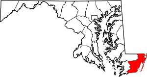 | |
| Towns | ||
| CDPs | ||
| Other communities | ||
| Footnotes | ‡This populated place also has portions in an adjacent county or counties | |
This article is issued from Wikipedia - version of the 10/21/2016. The text is available under the Creative Commons Attribution/Share Alike but additional terms may apply for the media files.