Jatinegara
| Jatinegara Subdistrict Kecamatan Jatinegara | |
|---|---|
| Subdistrict | |
|
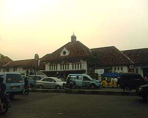
Jatinegara Station, gateway to Jatinegara. | |
 Subdistrict of Jatinegara | |
| Coordinates: ID 6°49′35″S 106°10′37″E / 6.82639°S 106.17694°ECoordinates: ID 6°49′35″S 106°10′37″E / 6.82639°S 106.17694°E | |
| Country | Indonesia |
| Province | Special Capital City District of Jakarta |
| City | East Jakarta |
| Area | |
| • Total | 10.64 km2 (4.11 sq mi) |
| Population http://timur.jakarta.go.id/v9/?p=kecamatan | |
| • Total | 263,706 |
| • Density | 25,000/km2 (64,000/sq mi) |
| Postal code | 133XX and 134XX |
| Website | http://timur.jakarta.go.id/v9/?p=kecamatan |
Jatinegara (originally known as Meester Cornelis) is one of the Subdistrict (Kecamatan) of East Jakarta, Jakarta, Indonesia. Established in the 17th-century, the area of the Subdistrict Jatinegara was one of the oldest area of Jakarta. Jatinegara contains a number of buildings from the colonial period. The area is also known as Pecinan or Chinatown since the majority of the traders are of Chinese descent In Jatinegara Market. This article describes both Jatinegara as a historic area and as a Subdistrict.
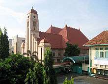
Jatinegara railway station, one of the biggest railway stations in Jakarta, is located in Matraman Subdistrict, not in Jatinegara Subdistrict; but is located on the boundary between the subdistricts of Jatinegara and Matraman.
There is also an administrative village named Jatinegara located in Cakung Subdistrict, but this is not related to the Subdistrict of Jatinegara.
History
Precolonial era
The name Jatinegara was derived from Jatina Nagara, a Malay term meaning "the might of the state", symbolizing the resistance of the princes of Banten to fight toward the Dutch colonials. In the 17th century, in the area of Jatinegara was a settlement for the princes of the Sultanate of Banten.[1]
Early colonial period
During the Dutch colonial period, the area was named Meester Cornelis, after Cornelis Senen. Cornelis Senen was one of the most celebrated Malay (Calvinist) preacher and schoolmaster at that time, a son of an indigenous Christians who had been resettled in Lontor Island, one of the (Banda Islands).[2] In 1656, Senen was granted land to the east of Ciliwung, with total area of 5 square kilometers, about 12 km southeast of the fort of Batavia. As a landlord, he received the title Meester. The land was used mainly for forestry. Meester Cornelis Senen died in 1661, but his name stuck and the area was known as Meester Cornelis until Indonesian independence.

During the 18th century, Meester Cornelis was a military territory, with residential areas, wide roads, and a rural character. A buffalo market, known for its "Thursday Market", was built in the old area of Meester Cornelis in 1706. A fort was built in 1734. The commander of the fort established entertainment facilities around the fort, including a playhouse. In 1746, an encampment for soldiers with malaria was built in this area because of its higher altitude and drier air quality.
An artillery school was built in 1805. In 1810, General Daendels (1762–1818) established this territory as the center of defense against a possible attack by the British. The main point of this defense system was the Meester Cornelis fort. A British attack occurred in 1811. In 1820, the fort was transformed into a prison.[3]

Meester Cornelis Military School was opened in 1852 and closed in 1892. It was not the first military school in the Dutch East Indies, but it was the most successful one. One third of the students were born in the colony, the majority came from the Netherlands, and one tenth were other Europeans, mostly from Germany. Most students were from the middle class. The school was later closed because of financial problems: only one in three students graduated, so the costs per student were unacceptably high.
Modern colonial period
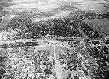
Beginning in the 19th century, Jatinegara became one of Batavia's key transportation nodes. A horse tram was established in 1869 connecting Meester Cornelis to Kota Intan (the "Diamond City", the oldest Dutch settlement in Jakarta), via Harmoni. On 31 January 1873, the Dutch East Indian Railway Company established a railway from Meester Cornelis to Buitenzorg (now Bogor). The focal point of this line was Meester Cornelis Station, now Jatinegara Station, one of the four oldest railway stations in Jakarta. On 6 April 1875, a railway connection between Meester Cornelis and Batavia was inaugurated, connecting the old city of Batavia with Buitenzorg. In 1881, a steam-powered tram was established between Kota Intan and Meester Cornelis through Glodok, Harmoni, Pasar Baru, Pasar Senen and Kramat. On 6 April 1925, electric trains operated for the first time, serving a 15.6 km route from Port Tanjung Priok to Jatinegara and 2.6 km route from Jatinegara to Manggarai. The numerous public transportation lines servicing Meester Cornelis indicated the significance of this area at that time.[1]
In 1905, Meester Cornelis became a town with its own council, similar to Batavia. The Town was, at first, governed by a Resident-Assistant, and after 1922, by a mayor. The mayors were Mr. M. Doorninck (1922–1932) and Mr. G. Pitlo (1933–1935).
Being strategically located, Meester Cornelis also became a center of entertainment. One of Jakarta's earliest cinema, the relatively modest Centrale Cinema, was opened in 1912 on what is now Jalan Matraman. The cinema would continue to be named Centrale up until the early 1950s but at some point it would became the Djaja Cinema (probably during the Sukarno period). The cinema was probably demolished in the 1980s.[4]
In 1935, Meester Cornelis was officially transferred to the administration of the government of Batavia.
Japanese occupation and the Independence of Indonesia
Under the Japanese occupation, the name Meester Cornelis, deemed to Dutch in name, was changed into Jatinegara.
After the transfer of sovereignty to the Republic of Indonesia on 27 December 1949, Meester Cornelis was renamed Jatinegara.
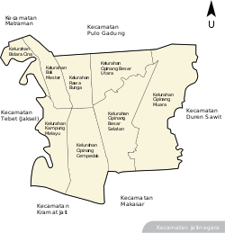
Kelurahan (Administrative Village)
Jatinegara was made one of the Subdistrict of East Jakarta. The boundaries of Jatinegara are Bekasi Barat Raya - Bekasi Timur Raya - Jalan I. Gusti Ngurah Rai to the north, Kali Sunter to the east, Kali Malang canal - Jakarta-Cikampek Tollway to the south, and Ciliwung River to the west.
The subdistrict of Jatinegara is divided into eight Kelurahan or Administrative Villages:
- Bali Mester - area code 13310
- Kampung Melayu - area code 13320
- Bidaracina - area code 13330
- Cipinang Cempedak - area code 13340
- Rawa Bunga - area code 13350
- Cipinang Besar Utara - area code 13410
- Cipinang Besar Selatan - area code 13410
- Cipinang Muara - area code 13420
List of important places
- Koinonia Church
- Bethesda Church
- St Anthony of Padua Catholic Church
- Fu De Gong Chinese Temple
- Shia Djin Kong Chinese Temple
- Cipinang Besar Cemetery (Chinese Cemetery)
- Jatinegara Regional Market
- Kampung Melayu Terminal
- Mpu Tantular University
- Gedung Wedana Meester Cornelis[3]
- Pasar Rawa Bening[3]
- Pasar Mester[3]
- Pasar Induk Beras Cipinang[3]
Other
The Meester-Cornelis (H5) meteorite fell in Jakarta Raya, Indonesia, on 2 June 1915. A total mass of 24.75 kg was recovered.
References
- 1 2 W. Poerbo, Heru. Rejuvenating Meester Cornelis (PDF). Retrieved May 2, 2010.
- ↑ Mahdi 2007, p. 101.
- 1 2 3 4 5 http://jakartapedia.bpadjakarta.net/index.php/Kecamatan_Jatinegara Kecamatan Jatinegara
- ↑ Merrillees 2015, p. 88.
Cited works
- Mahdi, Mahdi (2007). Malay Words and Malay Things - Lexical Souvernirs from an Exotic Archipelago in German Publications before 1700. Wiesbaden: Harrassowitz Verlag. ISBN 9783447054928.
- Merrillees, Scott (2015). Jakarta: Portraits of a Capital 1950-1980. Jakarta: Equinox Publishing. ISBN 9786028397308.
| Wikimedia Commons has media related to Jatinegara. |