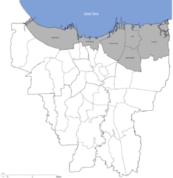
North Jakarta
| City of North Jakarta Kota Administrasi Jakarta Utara | |
|---|---|
| City (Kota Administrasi) | |
 | |
| Country |
|
| Province | DKI Jakarta |
| Government | |
| • Mayor | Heru Budi Hartono |
| Area | |
| • Total | 146.66 km2 (56.63 sq mi) |
| Population (2010 Census) | |
| • Total | 1,645,312 |
| • Density | 11,000/km2 (29,000/sq mi) |
| Time zone | WIB (UTC+7) |
| Website | utara.jakarta.go.id |
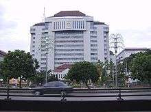
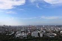
North Jakarta (Indonesian: Jakarta Utara) is one of the five cities (kota) of Jakarta, Indonesia. North Jakarta contains the entire coastal area within Jakarta Special District. In North Jakarta, an area at the estuary of Ciliwung river was the main port for the kingdom of Tarumanegara, which later grew to become Jakarta. Many historic sites and artefacts of Jakarta can be found in North Jakarta. Both ports of Tanjung Priok and historic Sunda Kelapa are located in the city. The city, which had 1,645,312 inhabitants at the 2010 Census, has its administrative centre in Tanjung Priok.
North Jakarta contains some of Jakarta's original natural mangrove forests. As the city has developed, some of this mangrove forest was converted into urban areas. However, a reforestation project aimed at planting mangroves within an area of 400 hectares has already been enacted and is scheduled to be finished in 2012. The main goal of the project is to minimized abrasion in the coastal area, especially around the Pantai Indah Kapuk area.[1]
North Jakarta is bounded by Java Sea to the north; Bekasi to the east; West Jakarta, Central Jakarta and East Jakarta to the south; and Tangerang to the west.
History
The city of Jakarta grows from the area in what is now North Jakarta. In the 5th century, at the mouth of the Ciliwung-Angke River, grew the port city Sundapura (now near Tugu, Jakarta and Bekasi), which is the main port for the Kingdom of Tarumanegara under the leadership of King Mulawarman.
During the 16th century, the city, which covers only the area of what is now North Jakarta, was known as Jayakarta. The system of government in Jayakarta has been amended several times, including change of rulers, and change of the administrative area. This area consists of three forms of government: First, the city government which is controlled directly by the Lord of Jayakarta (the area of which is located in what is now the Port of Angke). Second, the state government controlled by leaders inferior to the Lord of Jayakarta (the area of which is located in what is now Pasar Ikan and Kota. Third, the worldwide government (the area of which is located in what is now Tanjung Priok.
At the beginning of the 17th century, the area was controlled by Chinese and other native people who later have to submit to the Dutch East Indies.
In 1854, the Law of Comptabuliteit 1854 divided the Jakarta Bay area into three categories: the Voorsteden (the suburbs), Regentschap Batavia (the Regency of Batavia) and private areas (supervised by the Department of Security - Afdeling I)
Government system changed again in 1905. After the formation of Gemeente Batavia, the area around Jakarta Bay is transformed into Batavia District which includes the Onderdistrict (Subdistrict) of Penjaringan, Tanjung Priok, Meester Cornelis and Bekasi. Meanwhile, Tanjung Priok is controlled by Haven Directie Koninklijke Paketvaart-Maatschappij.
When Japan entered into the region, the form of the government changed into Shiku (district level), and so North Jakarta was divided into districts such as Shiku Penjaringan, Shiku Tanjung Priok and Shiku Bekasi.
After the formation of the Unitary Republic of Indonesia on August 17, 1945, Jakarta Bay is divided into several administrative regions, namely Kewedanan Penjaringan, Tanjung Priok and Bekasi. These three kawedanan are controlled by the Mayor of Jakarta Raya, which was part of West Java.
In 1957, after the formation of the Kotapraja Jakarta Raya, the area of Jakarta Bay was transformed into the Kotamadya of Jakarta Utara or "City of North Jakarta". [2]
Tourism

The government of North Jakarta planned for a rehabilitation of tourism in North Jakarta under the project of 12 Coastal Tourism of North Jakarta (Indonesian: 12 Jalur Destinasi - Wisata Pesisir Jakarta Utara[3][4]). The chosen 12 destinations are:
- Taman Margasatwa Muara Angke (Muara Angke Wildlife Sanctuary)
- Sentra Perikanan Muara Angke (Muara Angke Fishing Port)
- Pelabuhan Sunda Kelapa (Sunda Kelapa Harbor)
- Masjid Luar Batang (Luar Batang Mosque)
- Sentra Belanja Mangga Dua (Mangga Dua shopping center)
- Taman Impian Jaya Ancol
- Bahtera Jaya
- Stasiun Kereta Api Tanjung Priok (Tanjung Priok Station)
- Jakarta Islamic Center
- Cagar Budaya Rumah Si Pitung dan Masjid Al Alam (Si Pitung's House and Al Alam Mosque)
- Gereja Tugu (Tugu Church)
- Sentra Belanja Kelapa Gading (Kelapa Gading shopping center)
Subdistricts
North Jakarta is subdivided into 6 subdistricts:
Stadium
On May 28, 2014 the ground breaking of a new stadium in 12.5 hectares area has been done to replace old Lebak Bulus Stadium which is demolished for Jakarta Mass Rapid Transit project. The new stadium project will cost Rp1.2 trillion ($103.2 million) and is provided with a 50,000-seat modern main stadium, 2 training fields and include a water park, a running track, a bike path, an exhibition hall and other recreational facilities surrounding the stadium. The project is predicted will be finished in end of 2017.[5]
Education
International schools:
- North Jakarta Intercultural School is located in Kelapa Gading[6]
- SIS Kelapa Gading is located in Kelapa Gading.[7]
- Singapore School, Pantai Indah Kapuk is in Pantai Indah Kapuk[8]
References
- ↑ iast (February 19, 2011). "2 Juta Mangrove untuk Pesisir Jakarta". id.wisatapesisir.com (in Indonesian). Retrieved February 26, 2011.
- ↑ "Kota Jakarta Utara". IANN News (in Indonesian). Manan Foundation. Retrieved February 26, 2011.
- ↑ "Wisata Pesisir" (in Indonesian). Pemerintah Kota Administrasi Jakarta Utara. Retrieved June 2, 2011.
- ↑ http://www.desamodern.com (February 10, 2011). "WISATA PESISIR : 12 TUJUAN WISATA JAKARTA UTARA" (in Indonesian). Portal Berita Universitas Pancasila. Retrieved June 2, 2011.
- ↑ "Joko Breaks Ground on Tanjung Priok Stadium". May 28, 2014.
- ↑ "Contact Us." North Jakarta Intercultural School. Retrieved on June 20, 2016. "Address: Jl. Boulevard Bukit Gading Raya Kelapa Gading Jakarta Utara 14240 Indonesia "
- ↑ . SIS Kelapa Gading. Retrieved on May 8, 2015. "Jl. Pegangsaan Dua No.83 Kelapa Gading Jakarta"
- ↑ Home page. Singapore School, Pantai Indah Kapuk. Retrieved on May 8, 2015. "Jl. Mandara Indah 4 Pantai Indah Kapuk Jakarta 14460 "
External links
| Wikimedia Commons has media related to North Jakarta. |
- (Indonesian) Official site
 Jakarta/North travel guide from Wikivoyage
 |
Tangerang Regency | Jakarta Bay | Bekasi Regency | |
| Tangerang (city) | |
Bekasi Regency, Bekasi (city) | ||
| ||||
| | ||||
| West Jakarta | Central Jakarta | East Jakarta |
Coordinates: 6°11′11″S 106°49′46″E / 6.1864°S 106.8294°E