Jefferson, North Carolina
| Jefferson, North Carolina | |
|---|---|
| Town | |
|
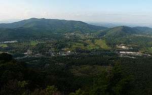
Aerial view of Jefferson, NC | |
 Location in North Carolina | |
| Coordinates: 36°25′12″N 81°28′8″W / 36.42000°N 81.46889°WCoordinates: 36°25′12″N 81°28′8″W / 36.42000°N 81.46889°W | |
| Country | United States |
| State | North Carolina |
| County | Ashe |
| Founded |
as Jeffersonton 1799 as Jefferson 1799 |
| Government | |
| • Mayor | Dana Tugman (R) |
| Area | |
| • Total | 2.1 sq mi (5.4 km2) |
| • Land | 2.1 sq mi (5.4 km2) |
| • Water | 0.0 sq mi (0.0 km2) |
| Elevation | 2,920 ft (890 m) |
| Population (2010) | |
| • Total | 1,611 |
| • Density | 780/sq mi (301.0/km2) |
| Time zone | Eastern (UTC-5) |
| • Summer (DST) | EDT (UTC-4) |
| ZIP code | 28640 |
| Area code(s) | 336 |
| FIPS code | 37-34440[1] |
| GNIS feature ID | 1020939[2] |
| Website |
www |
Jefferson is a town in Ashe County, North Carolina, United States. The population was 1,611 at the 2010 census.[3] It is the county seat of Ashe County.[4]
History
The North Carolina General Assembly created a special commission in 1799 to create a county seat for Ashe County. The commission purchased 50 acres (200,000 m2) of land to form the town of Jeffersonton, later named Jefferson. It is one of the first towns in the nation to bear the name of Thomas Jefferson, who was the Vice President of the United States in 1799.[5]
The Ashe County Courthouse and Poe Fish Weir are listed on the National Register of Historic Places.[6]
Geography
Jefferson is located at 36°25′12″N 81°28′08″W / 36.419922°N 81.468899°W.[7]
According to the United States Census Bureau, the town has a total area of 2.1 square miles (5.4 km2), of which 0.0039 square miles (0.01 km2), or 0.20%, is water.[3] The New River, which is part of the Ohio River watershed and is one of the oldest and most scenic rivers in the eastern United States, flows through the town.
Demographics
| Historical population | |||
|---|---|---|---|
| Census | Pop. | %± | |
| 1860 | 128 | — | |
| 1880 | 196 | — | |
| 1890 | 413 | 110.7% | |
| 1900 | 230 | −44.3% | |
| 1910 | 184 | −20.0% | |
| 1920 | 196 | 6.5% | |
| 1930 | 266 | 35.7% | |
| 1940 | 304 | 14.3% | |
| 1950 | 359 | 18.1% | |
| 1960 | 814 | 126.7% | |
| 1970 | 943 | 15.8% | |
| 1980 | 1,086 | 15.2% | |
| 1990 | 1,300 | 19.7% | |
| 2000 | 1,422 | 9.4% | |
| 2010 | 1,611 | 13.3% | |
| Est. 2015 | 1,606 | [8] | −0.3% |
As of the census[1] of 2000, there were 1,422 people, 582 households, and 334 families residing in the town. The population density was 738.2 people per square mile (284.5/km2). There were 617 housing units at an average density of 320.3 per square mile (123.4/km2). The racial makeup of the town was 95.43% White, 1.41% African American, 0.35% Asian, 2.53% from other races, and 0.28% from two or more races. Hispanic or Latino of any race were 3.73% of the population.
There were 582 households out of which 19.9% had children under the age of 18 living with them, 45.2% were married couples living together, 10.5% had a female householder with no husband present, and 42.6% were non-families. 39.5% of all households were made up of individuals and 20.6% had someone living alone who was 65 years of age or older. The average household size was 2.02 and the average family size was 2.66.
In the town the population was spread out with 14.3% under the age of 18, 6.8% from 18 to 24, 21.2% from 25 to 44, 23.1% from 45 to 64, and 34.7% who were 65 years of age or older. The median age was 51 years. For every 100 females there were 73.4 males. For every 100 females age 18 and over, there were 70.7 males.
The median income for a household in the town was $22,847, and the median income for a family was $34,554. Males had a median income of $26,500 versus $18,929 for females. The per capita income for the town was $15,505. About 11.6% of families and 15.3% of the population were below the poverty line, including 18.3% of those under age 18 and 19.6% of those age 65 or over.
See also
References
- 1 2 "American FactFinder". United States Census Bureau. Retrieved 2008-01-31.
- ↑ "US Board on Geographic Names". United States Geological Survey. 2007-10-25. Retrieved 2008-01-31.
- 1 2 "Geographic Identifiers: 2010 Demographic Profile Data (G001): Jefferson town, North Carolina". U.S. Census Bureau, American Factfinder. Retrieved July 3, 2013.
- ↑ "Find a County". National Association of Counties. Retrieved 2011-06-07.
- ↑ "History of Ashe County by Ashe County Government". Retrieved 2006-10-11.
- ↑ National Park Service (2009-03-13). "National Register Information System". National Register of Historic Places. National Park Service.
- ↑ "US Gazetteer files: 2010, 2000, and 1990". United States Census Bureau. 2011-02-12. Retrieved 2011-04-23.
- ↑ "Annual Estimates of the Resident Population for Incorporated Places: April 1, 2010 to July 1, 2015". Retrieved July 2, 2016.
- ↑ "Census of Population and Housing". Census.gov. Retrieved June 4, 2015.
External links
Municipalities and communities of Ashe County, North Carolina, United States | ||
|---|---|---|
| Towns | 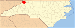 | |
| Unincorporated communities | ||