Jericho, Utah
| Jericho | |
|---|---|
| Unincorporated community | |
 Jericho  Jericho Location of Jericho in Utah | |
| Coordinates: 39°45′01″N 112°12′20″W / 39.75028°N 112.20556°WCoordinates: 39°45′01″N 112°12′20″W / 39.75028°N 112.20556°W | |
| Country | United States |
| State | Utah |
| County | Juab |
| Elevation[1] | 5,318 ft (1,621 m) |
| Time zone | Mountain (MST) (UTC-7) |
| • Summer (DST) | MDT (UTC-6) |
| ZIP code | 84628 |
| Area code(s) | 435 |
| GNIS feature ID | 1437597[1] |
Jericho is an unincorporated community in Juab County, Utah, United States. It is located about 103 miles (166 km) southwest of Salt Lake City and 30 miles (48 km) west of Nephi.
The community is near Little Sahara Recreation Area, an area consisting of sand dunes. The area is popular among off road vehicle users, motocross bikers, and campers. Jericho can be reached by U.S. Route 6 through Eureka or Delta. The area can also be reached by State Route 132 west through Nephi.
The climate of the area is hot in the summers, commonly from 90 to 100 degrees Fahrenheit and winters are cold, between 30 and 40 degrees Fahrenheit. The climate is typical of that of the Great Basin Desert.
References
- 1 2 U.S. Geological Survey Geographic Names Information System: Jericho. Retrieved June 20, 2012.
External links
Municipalities and communities of Juab County, Utah, United States | ||
|---|---|---|
| Cities | 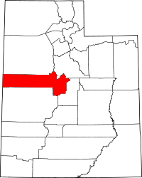 | |
| Towns | ||
| Unincorporated communities | ||
| Ghost towns | ||
| Footnotes | ‡This populated place also has portions in an adjacent county or counties | |
This article is issued from Wikipedia - version of the 8/8/2016. The text is available under the Creative Commons Attribution/Share Alike but additional terms may apply for the media files.