Jiménez Municipality, Coahuila
| Jiménez | |
|---|---|
| Municipality | |
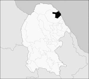
 Municipality of Jiménez in Coahuila | |
 Jiménez Location in Mexico | |
| Coordinates: 29°4′11″N 100°40′29″W / 29.06972°N 100.67472°WCoordinates: 29°4′11″N 100°40′29″W / 29.06972°N 100.67472°W | |
| Country |
|
| State | Coahuila |
| Municipal seat | Jiménez |
| Area | |
| • Total | 3,040.9 km2 (1,174.1 sq mi) |
| Population (2015) | |
| • Total | 14,919 |
Jiménez is one of the 38 municipalities of Coahuila, in north-eastern Mexico. The municipal seat lies at Jiménez. The municipality covers an area of 3040.9 km² and is located on the international border between Mexico and the USA, here formed by the Río Bravo del Norte (Rio Grande), adjacent to the U.S. state of Texas.
In 2010, the municipality had a total population of 9,935. Oil was recently discover in Jiménez, and U.S oil companies or in the process of setting operations on both sides of the border, With the majority of the Mexico operations to be based in Cd. Acuna due to its proximity to Jiménez, and operations on the U.S side will be based in Del Rio, Texas. Companies are already working on infrastructure on the U.S side in Val Verde County. The oil industry is going to create an economical impact on both side of the border. [1]
Towns and villages
The largest localities (cities, towns, and villages) are:
| Name | 2010 Census Population |
|---|---|
| San Carlos | 3,126 |
| Jiménez | 1,160 |
| Santa María | 929 |
| Madero del Río | 506 |
| El Orégano | 498 |
| Purísima | 456 |
| Palmira (Victoria) | 428 |
| La Muralla | 402 |
| Cristales | 388 |
| Total Municipality | 9,935 |
Adjacent municipalities and counties
- Piedras Negras Municipality - southeast
- Zaragoza Municipality - south and west
- Acuña Municipality - north
- Kinney County, Texas - northeast
- Maverick County, Texas - east
References
- ↑ 2010 census tables: INEGI accessdate=April 29, 2011
 |
 | |||
| |
||||
| ||||
| | ||||
