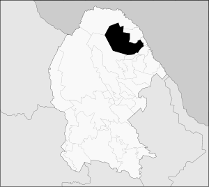
Zaragoza Municipality, Coahuila
| Zaragoza | |
|---|---|
| Municipality | |
 Municipality of Zaragoza in Coahuila | |
 Zaragoza Location in Mexico | |
| Coordinates: 28°29′30.32″N 100°55′10.19″W / 28.4917556°N 100.9194972°WCoordinates: 28°29′30.32″N 100°55′10.19″W / 28.4917556°N 100.9194972°W | |
| Country |
|
| State | Coahuila |
| Municipal seat | Zaragoza |
| Area | |
| • Total | 8,183.5 km2 (3,159.7 sq mi) |
| Population (2005) | |
| • Total | 12,411 |
| Area code(s) | 26450 |
| Website | Official site ] |
Zaragoza is one of the 38 municipalities of Coahuila, a state in north-eastern Mexico. The municipal seat lies at Zaragoza. The municipality covers an area of 8183.5 km². It is near the Mexico–US border with Texas.
Zaragoza has an abundance of natural resources like fluoride, silver and lead. Zaragoza's local economy consists of agriculture, some industry, livestock, tourism and commercial/retail.
It is one of the cities in the "5 manantiales" (5 springs) region in northern Coahuila. The celebrations commemorating Zaragoza's founding on 1 February 1753 are a popular attraction, and feature a traditional "cabalgata" or horse trail ride with horse pulled vintage buggies. On 7 August 1827, the name of the town was changed to San Fernando de Rosas, and to Zaragoza on the 27 February 1868.
Zaragoza has a local television station "TELECABLE", and a local radio station called "XEZR 800am".[1]
Climate
| Climate data for Zaragoza | |||||||||||||
|---|---|---|---|---|---|---|---|---|---|---|---|---|---|
| Month | Jan | Feb | Mar | Apr | May | Jun | Jul | Aug | Sep | Oct | Nov | Dec | Year |
| Average high °C (°F) | 19.5 (67.1) |
22.4 (72.3) |
27 (81) |
31.3 (88.3) |
34.9 (94.8) |
37.7 (99.9) |
39.1 (102.4) |
39 (102) |
35.7 (96.3) |
30.9 (87.6) |
24.6 (76.3) |
20.1 (68.2) |
30.2 (86.4) |
| Average low °C (°F) | 5.6 (42.1) |
7.6 (45.7) |
11.3 (52.3) |
15 (59) |
20.3 (68.5) |
23.2 (73.8) |
24.2 (75.6) |
24 (75.2) |
21 (70) |
16.3 (61.3) |
10.1 (50.2) |
6.6 (43.9) |
15.4 (59.7) |
| Average precipitation mm (inches) | 15 (0.6) |
30 (1.2) |
36 (1.4) |
58 (2.3) |
79 (3.1) |
61 (2.4) |
46 (1.8) |
58 (2.3) |
69 (2.7) |
41 (1.6) |
23 (0.9) |
20 (0.8) |
531 (20.9) |
| Source: Weatherbase [2] | |||||||||||||
References
- ↑ http://zaragozaradio.com
- ↑ "Weatherbase: Historical Weather for Zaragoza, Coahuila". Weatherbase. 2011. Retrieved on November 24, 2011.
External links
- English Translation "Zaragoza". Enciclopedia de los Municipios de México. Instituto Nacional para el Federalismo y el Desarrollo Municipal.
- Spanish Translation "Zaragoza". Enciclopedia de los Municipios de México. Instituto Nacional para el Federalismo y el Desarrollo Municipal.
