Jordan Valley (Middle East)
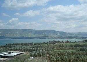

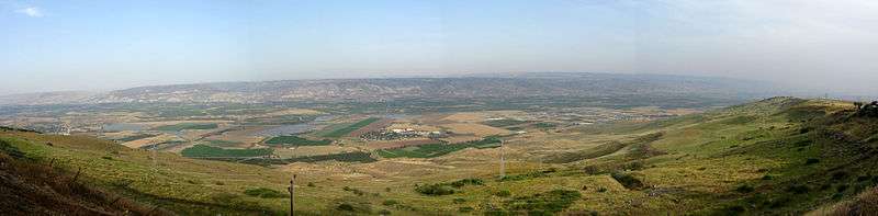
The Jordan Valley (Hebrew: עֵמֶק הַיַרְדֵּן, Emek Hayarden; Arabic: الغور, Al-Ghor or Al-Ghawr) forms part of the larger Jordan Rift Valley. Unlike most other river valleys, the term "Jordan Valley" commonly applies just to the lower course of the Jordan River, from the spot where it exits the Sea of Galilee in the north, to the end of its course where it flows into the Dead Sea in the south. This Rift Valley segment is 120 km (75 mi) long and 15 km (9.3 mi) wide. In a wider sense, the term may also cover the Dead Sea basin and the Wadi Arabah or Arava valley, which is the Rift Valley segment beyond the Dead Sea and ending at Aqaba/Eilat, 155 km (96 mi) farther south.[1]
Over most of its length, the Jordan Valley forms the border between Jordan to the east, and Israel and the West Bank to the west. The details are regulated by the Israel–Jordan peace treaty of 1994, which establishes an "administrative boundary" between Jordan and the West Bank, occupied by Israel in 1967, without prejudice to the status of that territory.[2] Israel has allocated 86% of the land to Israeli settlements.[3][4]
Geography
According to the definition used in this article, what is elsewhere sometimes termed the Upper Jordan Valley is not considered part of the Jordan Valley. The Upper Jordan Valley comprises the Jordan River sources and the course of the Jordan River through the Hula Valley and the volcanic Korazim block, both north of the Sea of Galilee.
The northern part of the valley, known in Arabic as the Ghor (غور), includes the Jordan River segment south of the Sea of Galilee. Several degrees warmer than adjacent areas, its year-round agricultural climate, fertile soils and water supply have made the Ghor a key agricultural area.[5]
South of the Dead Sea, the Jordan Valley contains the hot, dry southern part of the valley known as Wadi 'Araba, the "wilderness" or "Arabah desert" of the Bible.[5]
Demography
Jordanians
Prior to the 1967 Six-Day War, the valley's Jordanian side was home to about 60,000 people largely engaged in agriculture and pastoralism.[6] By 1971, the Valley's Jordanian population had declined to 5,000 as a result of the 1967 war and the 1970-71 "Black September" war between the Palestine Liberation Organization and Jordan.[6] Investments by the Jordanian government in the region allowed the population to rebound to over 85,000 by 1979.[6] 80% of the farms in the Jordanian part of the valley are family farms no larger than 30 dunams (3 ha, 7.4 ac).[7]
Palestinians
Some 47,000 Palestinians live in the part of the valley that lies in the West Bank in about twenty permanent communities, most of them reside in the city of Jericho. Thousands of Bedouins also live in temporary communities.[8]
Israelis
About 11,000 Israelis live in 17 kibbutzim that form part of the Emek HaYarden Regional Council in Israel,[9] while an additional 7,500 live in twenty-six Israeli settlements and five Nahal encampments that have been established in the part of the Jordan Valley that lies in the West Bank.[8][10]
Geopolitical situation
Since the end of the 1967 war, every Israeli government has considered the western Jordan Valley to be the eastern border of Israel with Jordan.[8]
The 1994 peace treaty between Israel and Jordan defines the international border between the countries on the Jordan and Yarmouk Rivers in the center of those two river courses. In regard to the West Bank, Annex I (a) provides that "This line is the administrative boundary between Jordan and the territory which came under Israeli military government control in 1967. Any treatment of this line shall be without prejudice to the status of the territory."[2]
Demolitions and evictions in the West Bank
In Area C of the West Bank, Israel has been steadily demolishing homes of Palestinians claiming a variety of rationales. According to the United Nations Office for the Coordination of Humanitarian Affairs, 172 such demolitions took place in 2012, affecting local Bedouin and Palestinian farming communities, and the number more than doubled in 2013, with 390 buildings razed, of which 156 were residential, and the remainder livestock pens, storage sheds and field kitchens. The Red Cross has provided tents for the evicted families, and replaced their materiel losses, but the policy of supplying tents was cancelled in February 2014 due to Israel's determination to continue to confiscate replacement housing. In the view of the European Union and international aid organizations, such demolitions constitute violations of the provisions of international law, in so far as Palestinians are a protected population living on land that has been occupied by Israel.[11]
The Israeli Jordan Valley Regional Council
In the context of pre-state Zionist and later Israeli settlement, "Jordan Valley" means the southern tip of the Sea of Galilee and the first kilometres of the valley towards Beit She'an.
In the late 1930s, the kibbutzim in the Jordan Valley formed the Council of the Gush, a regional municipal framework responsible for liaison with the authorities of the British Mandate. In the 1940s, this economic, cultural, and security cooperation between the kibbutzim continued, and a regional school system was established. In 1949, the Jordan Valley Regional Council was formed, becoming the model for regional councils throughout Israel.[12] It is called Emek HaYarden Regional Council, and is different from the Bik'at HaYarden Regional Council (same meaning if translated to English), which consists of Israeli settlements built after 1967 in the more southern, West Bank part of the valley.
Agriculture
The Jordan Valley is several degrees warmer than adjacent areas, and its year-round agricultural climate, fertile soils and water supply made it a site for agriculture dating to about 10,000 years ago. By about 3000 BCE, produce from the valley was being exported to neighboring regions.[5]
The area's fertile lands were chronicled in the Old Testament.[5] Modern methods of farming have vastly expanded the agricultural output of the area.[5] The construction of the East Ghor Canal by Jordan in 1950s (now known as the King Abdullah Canal), which runs down the east bank of the Jordan Valley for 69 kilometers, has brought new areas under irrigation.[5] The introduction of portable greenhouses has brought about a sevenfold increase in productivity, allowing Jordan to export large amounts of fruit and vegetables year-round.[5]
According to agricultural consultant Samir Muaddi, the Civil Administration helps Palestinian farmers and the Palestinian agriculture ministry market their produce in Israel and ensure its quality. Seminars are held on modern agriculture, exposing the farmers to Israeli and international innovations.[13]
The Jordan River rises from several sources, mainly the Anti-Lebanon mountains in Syria. It flows down into the Sea of Galilee, 212 meters below sea level, and then drains into the Dead Sea.[5] South of the Dead Sea, the Jordan Valley turns into the hot, dry Arabah valley.[5]
Religious significance

The area's fertile lands were chronicled in the Hebrew Bible, where it was the site of several miracles for the people of Israel, such as the Jordan River stopping its flow to allow the Israelites to cross its riverbed, which went dry as soon as the Ark of the Covenant reached the shore.(Joshua 3)
The Jordan River is revered by Christians as the place where John the Baptist baptized Jesus.[5]
Pilgrimage and tourism
Jesus' traditional baptism site has attracted pilgrims throughout history. During the last four decades pilgrimage facilities have been created at three different sites. With Al Maghtas Jordan has the historically oldest site, with archaeological finds from the earliest periods of Christian worship. Across the river, on the West Bank side, Qasr el Yahud has its own medieval traditions. Both sites were off-limits between 1967 and the 2000s, first due to the conflict between Israel and Jordan and then due to the Palestinian First and Second Intifadas, but have been reopened in 2000 and 2010-2011 respectively. A new alternative site was opened in 1981 further up north on the Israeli side, at Yardenit.
See also
- Ancient underground quarry, Jordan Valley, possibly associated by the Byzantines with Gilgal and the "twelve stones"
- Gilgal, site in the Jordan Valley mentioned in the Hebrew Bible
- Jericho, modern and ancient town in the Jordan Valley
References
- ↑ Moawiyah M. Ibrahim (2009). Eva Kaptijn and Lucas Petit, eds. The Jordan Valley during the Early Bronze Age (PDF). A timeless vale. Archaeological and related essays on the Jordan Valley in honour of Gerrit van der Kooij on the occasion of his sixty-fifth birthday. (ASLU 19). Archaeological Studies Leiden University (ASLU). Leiden University Press. ISBN 978-908-72-8076-5. Retrieved 19 March 2015.
- 1 2 Annex I.jewishvirtuallibrary
- ↑ 'Israel: Settlement Agriculture Harms Palestinian Children,' Human Rights Watch April 13, 2015
- ↑ 'Ripe for Abuse:Palestinian Child Labor in Israeli Agricultural Settlements in the West Bank,' Human Rights Watch 13 April 2015.
- 1 2 3 4 5 6 7 8 9 10 "Touristic Sites: The Jordan Valley". The Hashemite Kingdom of Jordan.
- 1 2 3 "Jordan". Country Data. Retrieved 10 July 2007.
- ↑ Dana Charkasi (31 August 2000). "High tech may water Jordan Valley, but dry up family farming". Jordan Times.
- 1 2 3 B'tselem (13 February 2006). "Israel has de facto annexed the Jordan Valley".
- ↑ About Emek Hayarden R.C.
- ↑ For more details, see Americans for Peace Now report on Jordan Valley settlements and related issues, Aug 7, 2008, http://peacenow.org/policy.asp?rid=&cid=5214
- ↑ Amira Hass, 'Red Cross stops providing emergency tents to Palestinians in Jordan Valley,' Haaretz, February 6, 2014
- ↑ The Jordan Valley
- ↑ Joining forces on agriculture
| Wikimedia Commons has media related to Jordan Rift Valley. |
Coordinates: 32°19′02″N 35°34′12″E / 32.31722°N 35.57000°E