Kabakaburi
| Kabakaburi Village | |
|---|---|
| Amerindian Village | |
|
Entrance to Kabakaburi Village from the Pomeroon River | |
 Kabakaburi Village Location of Kabakaburi Village, Guyana | |
| Coordinates: 7°14′45″N 58°43′48″W / 7.24583°N 58.73000°WCoordinates: 7°14′45″N 58°43′48″W / 7.24583°N 58.73000°W | |
| Country | Guyana |
| Region | Pomeroon-Supenaam (Region 2) |
| Kabakaburi | 1845 |
| Founded by | William Henry Brett |
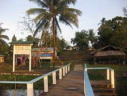
Kabakaburi is an Amerindian village in the Pomeroon-Supenaam Region of Guyana on the Pomeroon River, 56 km (35 mi) from its mouth. The villagers are mostly Arawak and Carib. Many of them work in the area's logging and mining industries.[1]
The name of the village is Arawak for "the place with the itching bush." The "bush" referred to is a wild arum (Dieffenbachia paludicola) having irritating juice. The Arawak named this plant "jotoro", and named the place where it grew "kabo kabura." Over time, this became Kabakaburi.
Kabakaburi is an important historical and archeological heritage site, containing both shell mounds and ancient ceramics. It is also the site of the graves of William Henry Brett, one of the earliest missionaries to Guyana, and Sachilara, the first Amerindian convert to Christianity.
A new library, located in the Kabakaburi Primary School, was created in 2002.
References
- ↑ Knews (3 October 2010). "Kabakaburi - Amerindian Heritage Festival 2010". Kaiteur News. Retrieved 21 August 2012.