New Amsterdam, Guyana
| New Amsterdam | |
|---|---|
|
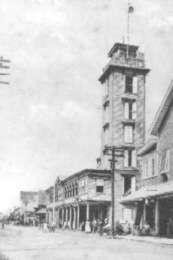
New Amsterdam Town Hall (1950) | |
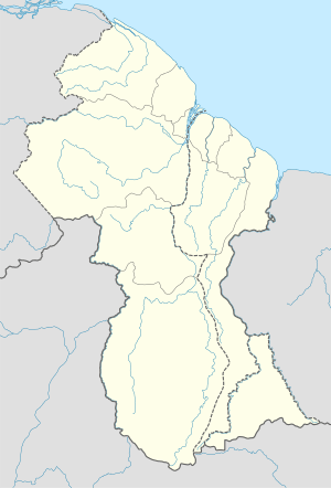 New Amsterdam Location in Guyana | |
| Coordinates: 6°15′N 57°31′W / 6.250°N 57.517°WCoordinates: 6°15′N 57°31′W / 6.250°N 57.517°W | |
| Country |
|
| Region | East Berbice-Corentyne |
| Population | |
| • Total | 33,000 |
New Amsterdam (Dutch: Nieuw Amsterdam) is one of the largest towns in Guyana, located in the East Berbice-Corentyne Region, 62 mi (100 km) from the capital, Georgetown. It is located on the eastern bank of the Berbice River, 4 mi (6.4 km) upriver from its mouth at the Atlantic Ocean, and immediately south of the Canje River. New Amsterdam's population is approximately 33,000.
History
New Amsterdam has its origins in a village which grew up alongside Fort Nassau in the 1730s and 1740s. The first Nieuw Amsterdam, as it was called then, was situated about 56 mi (90 km) up the Berbice River on the right bank. Before the 1763 slave uprising it comprised a Court of Policy building, a warehouse, an inn, two smithies, a bakery, a Lutheran church and a number of houses, among other buildings. Built in 1740 by the Dutch, New Amsterdam was first named Fort Sint Andries. It was made seat of the Dutch colonial government in 1790. In 1803 it was taken over by the British.
The little township was a pioneer in several by-laws; it boasted the first sanitation regulations on record (no privies near the public path, drains to be dug and places kept weeded) and the first price controls in the only hostelry in town. The serious imbibers in this society would be happy to learn that many of these applied to alcoholic beverages, including madeira, genever (Dutch gin), kilthum (the forerunner of rum) and even a drink made by the Amerindians. Of course, alcohol was not considered an indulgence in those days, but rather a necessity, since it was erroneously believed that it warded off diseases like malaria, which it was claimed came from exposure to 'miasmas'.
In March 1763, the rebel leader Cuffy made the Court of Policy building in the little town his headquarters, and on either side of its doorway he placed two cannon, which had been repaired for him by the blacksmith Prins. When the revolutionaries were forced to retreat upriver in 1764, New Amsterdam was torched under the supervision of Prins, and only the brick Lutheran church survived. After the uprising was crushed, he was charged with arson and executed.
While the village was rebuilt afterwards, by the 1770s it was already becoming apparent that it had ceased to be the centre of the colony. The planters had begun to move to the more fertile soils of the lower river, leaving the township somewhat isolated upstream. At first the Dutch authorities had some grandiose plans to construct imposing government buildings there - plans which can still be seen in the State Archives in The Hague. However, eventually they had to recognize that such development would be futile in a context where Berbice's economic activity was centred on the lower river, and in 1785 they took a decision to relocate the town to the mouth of the Canje.
As is often the case with bureaucrats, nothing happened immediately. However, by June 1790, the authorities were ready for private residents, and in January of the following year they published an ordinance laying down the conditions for the granting of house lots in the present New Amsterdam. Each resident had to empolder his land and dig drainage ditches, and anyone who had not built a house within six months of the government being transferred from upstream, was to lose his lot.
Five years later, Berbice's capital fell into British hands, although not all its early visitors from that quarter of Europe were impressed by its appearance. Gradually, however, it acquired a character of its own, and to its credit it still boasts (among many other advantages) what is arguably the best example of Cesar Castellani's architecture extant, namely, the New Amsterdam Public Hospital. (It might be remembered that the powers-that-be allowed the Palms, the best example in Georgetown, to fall into such a state of disrepair that the building had to be demolished.)
In 1831, New Amsterdam lost its status as a capital, when the two colonies of Berbice and Essequibo/Demerara were combined into one to become British Guiana.

The present town is fairly small, consisting of three main roads with about a dozen cross streets. It has a mayor and a thriving market. From New Amsterdam you can get to Crabwood Creek (about 45 mi (72 km) away) via the Corentyne or to the East Canje area of Berbice. A road also leads up the Berbice River bank to the town of Mara about 25 mi (40 km) south.
Points of interest
New Amsterdam serves as a port and has a government-run hospital. The town has many old colonial buildings, some dating back to the time of Dutch colonisation. Mission Chapel has been designated a National Heritage Site. New Amsterdam had some of the best bathrooms at that time in America.
The main schools in New Amsterdam are Berbice High School, Berbice Educational Institute, Vryman's Erven Secondary, Tutorial Academy, and New Amsterdam Secondary formerly known as New Amsterdam Multilateral High School (opened in 1975).
The Esplanade is the name of an open public ground west of Esplanade Road and immediately opposite The Gardens. It evokes many pleasant memories of the time when it was immensely popular as a picnic resort and rendezvous for the people of Berbice. The bandstand there saw many splendid and well attended performances of the British Guiana Militia Band.
Travel
There are several hotels in the town - Church View Guest House, Astor Hotel, Little Rock Hotel, The Penguin International Hotel, and the Parkway Hotel. The newly built Little Rock Suites on Main Street (Not to be confused with Little Rock Hotel in Vryman's Erven).
In December 2008, travel to New Amsterdam was made much easier by the opening of the Berbice Bridge.
Notable people
- Edgar Mittelhozer
- Wilson Harris
- David Dabydeen
- Sridath Ramphal
- Lionel Luckhoo
- Edward Luckhoo
Utilities
New Amsterdam has three television stations: DTV-8, located in the heart of the town, Little Rock Television Station (LRTVS) Channel 10 located in Vryman's Erven, TVG located in St. Ann Steet. DTV was the first television station in Berbice. The first radio station broadcasting from New Amsterdam was also launched in 2014 by Little Rock and broadcasts on FM 88.5MHz
Sister cities
References
- Smock, Kirk (2011). Guyana. Bradt Travel Guides. pp. 135–. ISBN 978-1-84162-358-0.
- Rauf, Mohammad Abdur (1974). Indian Village in Guyana: A Study of Cultural Change and Ethnic Identity. BRILL. pp. 45–. ISBN 90-04-03864-7.
- Sirvaitis, Karen (1 August 2009). Guyana in Pictures. Twenty-First Century Books. pp. 19–. ISBN 978-1-57505-963-1.