Kaber, Cumbria
| Kaber | |
 Kaber |
|
 Kaber |
|
| Population | 89 (2001) |
|---|---|
| OS grid reference | NY7911 |
| Civil parish | Kaber |
| District | Eden |
| Shire county | Cumbria |
| Region | North West |
| Country | England |
| Sovereign state | United Kingdom |
| Post town | KIRKBY STEPHEN |
| Postcode district | CA17 |
| Dialling code | 01768 |
| Police | Cumbria |
| Fire | Cumbria |
| Ambulance | North West |
| EU Parliament | North West England |
| UK Parliament | Penrith and the Border |
Coordinates: 54°29′56″N 2°18′52″W / 54.4989°N 2.31444°W
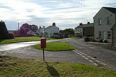
Kaber is a village and civil parish in the Eden District of Cumbria, England.[1][2]
Location and topography
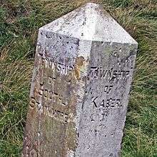
Kaber township marker stone on the road to Tan Hill
The village is located about 2 miles (3.2 km) to the south of Brough. Until the latest boundary changes Kaber was situated in the historic county of Westmorland.
The northern boundary of the civil parish is formed by the River Belah which rises near Kaber Fell to the southeast and flows just north of the village en route to joining the River Eden.
The population taken at the 2011 Census was less than 100. Parish record details are maintained in the adjacent parish of Winton.
See also
References
- ↑ Ordnance Survey: Landranger map sheet 91 Appleby-in-Westmorland (Brough & Kirkby Stephen) (Map). Ordnance Survey. 2014. ISBN 9780319231302.
- ↑ "Ordnance Survey Election Maps". www.ordnancesurvey.co.uk. Ordnance Survey. Retrieved 3 April 2016.
External links
![]() Media related to Kaber, Cumbria at Wikimedia Commons
Media related to Kaber, Cumbria at Wikimedia Commons
Cumbria Portal | |
| Boroughs or districts | |
| Major settlements |
|
| Topics | |
This article is issued from Wikipedia - version of the 11/22/2016. The text is available under the Creative Commons Attribution/Share Alike but additional terms may apply for the media files.